
Fil:Adams bridge map.png
Adams_bridge_map.png (519 × 239 pixlar, filstorlek: 25 kbyte, MIME-typ: image/png)
| Denna fil tillhandahålls av Wikimedia Commons. Informationen nedan är kopierad från dess filbeskrivningssida. |
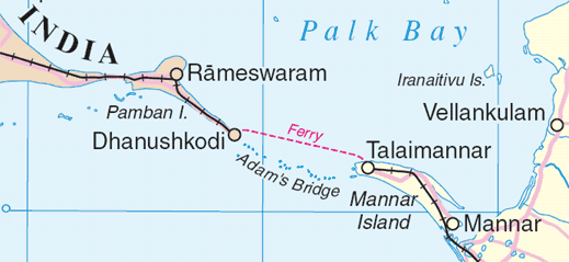
Map of en:Adam's Bridge, India/Sri Lanka
Extracted from www.un.org/Depts/Cartographic/map/profile/srilanka.pdf
| This image is a map derived from a United Nations map.
Unless stated otherwise, UN maps are to be considered in the public domain. This applies worldwide. UN maps are, in principle, open source material and you can use them in your work or for making your own map. UN requests however that you delete the UN name, logo and reference number upon any modification to the map. Content of your map will be your responsibility. You can state in your publication, if you wish, something like: based on UN map … (map name, map number, revision number and date). See: Geospatial Information Section. And: Geospatial, location data for a better world. |
 |
Filhistorik
Klicka på ett datum/klockslag för att se filen som den såg ut då.
| Datum/Tid | Miniatyrbild | Dimensioner | Användare | Kommentar | |
|---|---|---|---|---|---|
| nuvarande | 4 augusti 2006 kl. 03.55 | | 519 × 239 (25 kbyte) | Gugganij | Map of Adam's Bridge, India/Sri Lanka Extracted from http://www.un.org/Depts/Cartographic/map/profile/srilanka.pdf {{UN map}} |
Filanvändning
Följande 2 sidor använder den här filen:
Global filanvändning
Följande andra wikier använder denna fil:
- Användande på ar.wikipedia.org
- Användande på az.wikipedia.org
- Användande på ba.wikipedia.org
- Användande på be.wikipedia.org
- Användande på bn.wikipedia.org
- Användande på cs.wikipedia.org
- Användande på de.wikipedia.org
- Användande på el.wikipedia.org
- Användande på en.wikipedia.org
- Användande på eo.wikipedia.org
- Användande på es.wikipedia.org
- Användande på et.wikipedia.org
- Användande på fi.wikipedia.org
- Användande på fr.wikipedia.org
- Användande på fy.wikipedia.org
- Användande på gl.wikipedia.org
- Användande på gu.wikipedia.org
- Användande på he.wikipedia.org
- Användande på hu.wikipedia.org
- Användande på id.wikipedia.org
- Användande på it.wikipedia.org
- Användande på ja.wikipedia.org
- Användande på kn.wikipedia.org
- Användande på ko.wikipedia.org
- Användande på la.wikipedia.org
- Användande på lt.wikipedia.org
- Användande på mai.wikipedia.org
- Användande på mk.wikipedia.org
- Användande på ml.wikipedia.org
- Användande på new.wikipedia.org
Visa mer globalt användande av denna fil.