
Fil:Carte physique simplifiée de la France.svg

Originalfil (SVG-fil, standardstorlek: 1 797 × 1 796 pixlar, filstorlek: 336 kbyte)
| Denna fil tillhandahålls av Wikimedia Commons. Informationen nedan är kopierad från dess filbeskrivningssida. |
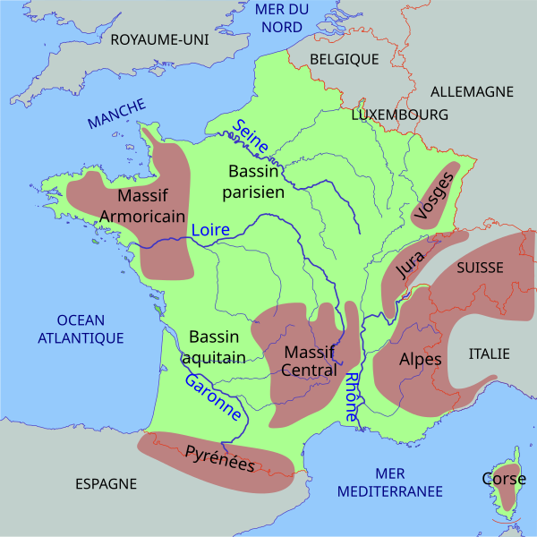
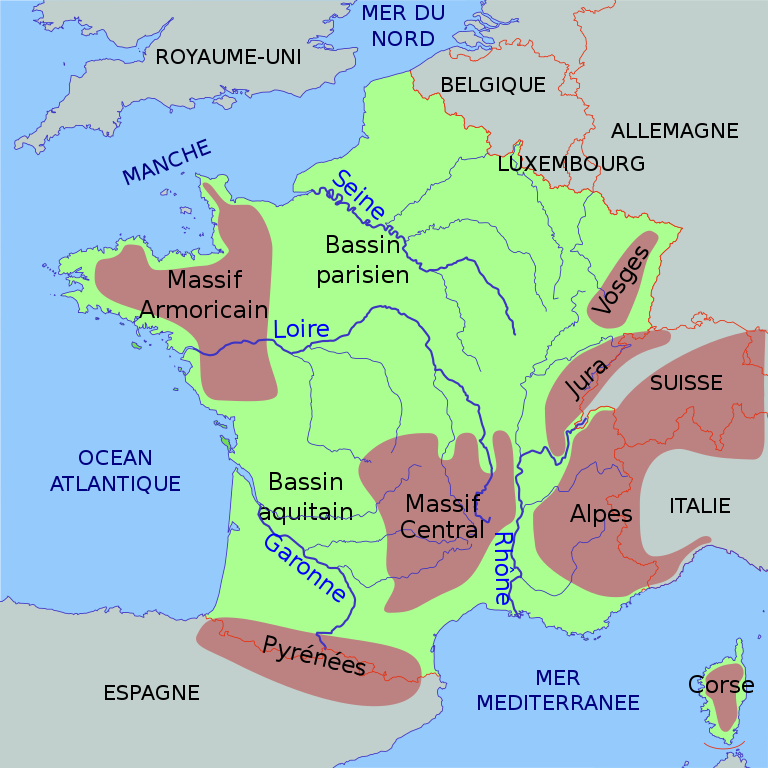
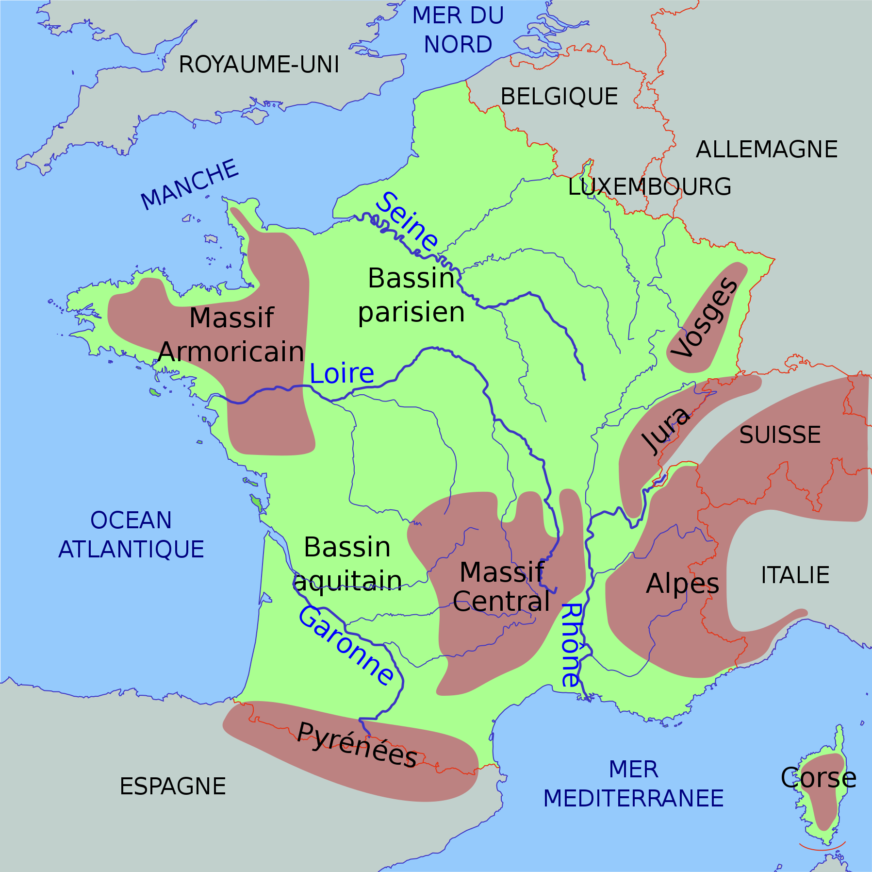
| Beskrivning | Carte de France très sommaire, avec les montagnes, les fleuves, les mers et les pays voisins. |
| Datum | (UTC) |
| Källa | |
| Skapare |
|
| Andra versioner | Derivative works of this file: Carte climatique de la France.svg |
- Du är fri:
- att dela – att kopiera, distribuera och sända verket
- att remixa – att skapa bearbetningar
- På följande villkor:
- erkännande – Du måste ge lämpligt erkännande, ange en länk till licensen och indikera om ändringar har gjorts. Du får göra det på ett lämpligt sätt, men inte på ett sätt som antyder att licensgivaren stödjer dig eller din användning.
- dela lika – Om du remixar, transformerar eller bygger vidare på materialet måste du distribuera dina bidrag under samma eller en kompatibel licens som originalet.
Although this is not compulsory, I'm always glad to read that my work is useful to others. If you could send me an e-mail at benji dot wiki at gmail dot com to inform me that you are using my work, I'd be delighted. Thanks a lot!
Envie d'utiliser cette image en dehors des projets Wikimedia ? N'hésitez pas ! Cette image est placée sous licence libre de façon à ce que vous puissiez l'utiliser librement, sans avoir besoin d'une autorisation de ma part. Tout ce que vous devez faire, c'est respecter les termes de la licence et me créditer ainsi :
Bien que ce ne soit pas obligatoire, je suis toujours ravi d'apprendre que mon travail a été utile à d'autres. Si vous pouviez m'envoyer un courriel à benji point wiki arobase gmail point com pour m'informer du fait que vous utilisez mon travail, ce serait top. Merci d'avance !
Ursprunglig uppladdningslogg
This image is a derivative work of the following images:
- File:France_cities.svg licensed with Cc-by-sa-2.5
- 2006-09-23T08:43:09Z Thire 1797x1796 (392032 Bytes) no far away countries, bigger cities, tried css, minor things, cher, ...
- 2006-09-20T07:14:40Z Thire 1797x1796 (375104 Bytes) now plain svg, not inkscape (thanks fZap at www.inkscape-forum.de)
- 2006-09-19T16:41:15Z Thire 1797x1796 (393377 Bytes) countrynames, NL rivers
- 2006-09-19T07:01:38Z Thire 1797x1796 (394229 Bytes) typo: Pyrenäen
- 2006-09-19T06:58:10Z Thire 1797x1796 (394229 Bytes) grey other countries, rivers just in france, mountains, details, ...
- 2006-09-17T16:55:36Z Thire 1797x1796 (356903 Bytes) {{Information| |Description = map of France with cities and rivers |Source = inkscape and the files below helped me. if you edit it: be aware of the fact that I added some CSS by hand (cities, ...) |Date = 17 sep. 2006 |Autho
Uploaded with derivativeFX
Filhistorik
Klicka på ett datum/klockslag för att se filen som den såg ut då.
| Datum/Tid | Miniatyrbild | Dimensioner | Användare | Kommentar | |
|---|---|---|---|---|---|
| nuvarande | 23 december 2022 kl. 22.44 | | 1 797 × 1 796 (336 kbyte) | Wikijahnn | File uploaded using svgtranslate tool (https://svgtranslate.toolforge.org/). Added translation for ca. |
| 29 april 2022 kl. 21.28 |  | 1 797 × 1 796 (323 kbyte) | Andrei Stroe | File uploaded using svgtranslate tool (https://svgtranslate.toolforge.org/). Added translation for ro. | |
| 26 november 2014 kl. 17.09 |  | 1 797 × 1 796 (315 kbyte) | Smallcog | Description : I had forgotten to reset the transform=scale(0.5) back to transform=scale(1.0) on the uppermost group. | |
| 26 november 2014 kl. 16.29 |  | 1 797 × 1 796 (315 kbyte) | Smallcog | Ignore previous version of Nov 26th, I made an error in uploading the file. The description from the previous version of Nov 26th is correct. | |
| 26 november 2014 kl. 16.20 |  | 1 797 × 1 796 (315 kbyte) | Smallcog | * Changes in this version ** Added more classes to give the following in total *** fleuves / oceanmer / nom / montagnes / zone / Niveau1 / Niveau2 / pays / bassin ** Corrected river path to ensure that the main part of each river was desribed in one si... | |
| 25 november 2014 kl. 13.21 |  | 1 797 × 1 796 (355 kbyte) | Smallcog | {{Information |Description=Update the previous version to provide the following :1. Crop the Alps outline to fit within the 1796*1796, 2.Remove all names in path format 3. Add text elements to provide names for countries, rivers, mountains. 4. Add clas... | |
| 6 januari 2010 kl. 00.12 |  | 1 797 × 1 796 (486 kbyte) | Benjism89 | {{Information |Description=Very basic physical map of France, with mountains, rivers, seas and nearby countries. |Source=*File:France_cities.svg |Date=2010-01-05 22:08 (UTC) |Author=*File:France_cities.svg: [[:de:Benutzer:Thire|Thomas Steiner] |
Filanvändning
Inga sidor använder den här filen.
Global filanvändning
Följande andra wikier använder denna fil:
- Användande på ca.wikipedia.org
- Användande på da.wikipedia.org
- Användande på el.wikipedia.org
- Användande på en.wikipedia.org
- Användande på frp.wikipedia.org
- Användande på fr.wikipedia.org
- Användande på fr.wikiversity.org
- Användande på incubator.wikimedia.org
- Användande på it.wikipedia.org
- Användande på ro.wikipedia.org