
Fil:Duchy of Prussia.svg

Storleken för denna PNG-förhandsvisning av denna SVG-fil: 610 × 588 pixlar. Andra upplösningar: 249 × 240 pixlar | 498 × 480 pixlar | 797 × 768 pixlar | 1 062 × 1 024 pixlar | 2 125 × 2 048 pixlar.
Originalfil (SVG-fil, standardstorlek: 610 × 588 pixlar, filstorlek: 55 kbyte)
| Denna fil tillhandahålls av Wikimedia Commons. Informationen nedan är kopierad från dess filbeskrivningssida. |
Sammanfattning
| Beskrivning |
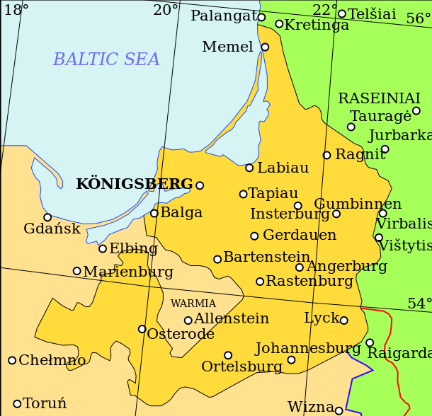
English: Map showing the Duchy of Prussia, at an indeterminable date. Place names inside the Duchy are given in German, as are Elbing and Marienburg. Other names are modern.
Territory of the Duchy of Prussia Territory of the Kingdom of Poland before the Union of Lublin Territory of the Grand Duchy of Lithuania before the Union of Lublin Polish-Lithuanian border before the Union of Lublin Polish-Lithuanian border after the Union of Lublin |
| Datum | |
| Källa | Eget arbete baserat på: (litauiska) (2001) Lietuvos istorijos atlasas, Vilnius: Vaga, pp. 16—17 |
| Skapare | Grandiose |
| Andra versioner |
|
| SVG utveckling | Den här Det karta skapades med Inkscape. |

| File | Type | Details |
|---|---|---|
| File:Polish-Lithuania map (1450-1600).svg | Large SVG | Map showing conflicts and territorial changes on the Polish-Lithuanian—Russian border, 1450–1600 |
| File:Duchy of Prussia.svg | Small SVG | Map of the Duchy of Prussia |
| File:Livonian war map (1558-1560).svg | Small SVG | Map showing campaigns in Livonia, 1558–1560. |
| File:Map of Poland and Lithuania after the Union of Lublin (1569).svg | Large SVG | Map of the w:Polish-Lithuanian Commonwealth after the Union of Lublin in 1569. |
| File:Livonian war map (1570-1577).svg | Small SVG | Map showing areas of Russian and Polish-Lithuanian forces, 1570–1577. |
| File:Campaigns of Stefan Batory.svg | Small SVG | Map of the campaign of Stefan Batory in Livonia (1575–1580). |
| File:Map of Poland and Lithuania in 1600.svg | Small SVG | Map of Livonia in 1600 |
| See also: User:Halibutt/maps, by Halibutt (diskussion · bidrag). | ||
.svg)
.svg)
.svg)
.svg)
Licensiering
Jag, upphovsrättsinnehavaren av detta verk, publicerar härmed det under följande licens:
Denna fil har gjorts tillgänglig under licensen Creative Commons Erkännande-Dela Lika 3.0 Generisk
- Du är fri:
- att dela – att kopiera, distribuera och sända verket
- att remixa – att skapa bearbetningar
- På följande villkor:
- erkännande – Du måste ge lämpligt erkännande, ange en länk till licensen och indikera om ändringar har gjorts. Du får göra det på ett lämpligt sätt, men inte på ett sätt som antyder att licensgivaren stödjer dig eller din användning.
- dela lika – Om du remixar, transformerar eller bygger vidare på materialet måste du distribuera dina bidrag under samma eller en kompatibel licens som originalet.
Filhistorik
Klicka på ett datum/klockslag för att se filen som den såg ut då.
| Datum/Tid | Miniatyrbild | Dimensioner | Användare | Kommentar | |
|---|---|---|---|---|---|
| nuvarande | 20 april 2011 kl. 12.07 | | 610 × 588 (55 kbyte) | Grandiose | Correct spelling |
| 19 april 2011 kl. 14.44 |  | 610 × 588 (54 kbyte) | Grandiose | Lines on longitude and latitude; other important fixes. | |
| 19 april 2011 kl. 14.36 |  | 610 × 588 (1,1 Mbyte) | Grandiose | Fix text locations | |
| 19 april 2011 kl. 14.33 |  | 610 × 588 (1,1 Mbyte) | Grandiose |
Filanvändning
Följande sida använder den här filen:
Global filanvändning
Följande andra wikier använder denna fil:
- Användande på ar.wikipedia.org
- Användande på ast.wikipedia.org
- Användande på br.wikipedia.org
- Användande på ca.wikipedia.org
- Användande på cs.wikipedia.org
- Användande på de.wikipedia.org
- Användande på el.wikipedia.org
- Användande på en.wikipedia.org
- Användande på eu.wikipedia.org
- Användande på fa.wikipedia.org
- Användande på fi.wikipedia.org
- Användande på gl.wikipedia.org
- Användande på he.wikipedia.org
- Användande på hr.wikipedia.org
- Användande på hu.wikipedia.org
- Användande på is.wikipedia.org
- Användande på it.wikipedia.org
- Användande på ja.wikipedia.org
- Användande på ko.wikipedia.org
- Användande på lt.wikipedia.org
- Användande på mk.wikipedia.org
- Användande på rue.wikipedia.org
- Användande på ru.wikipedia.org
- Användande på sc.wikipedia.org
- Användande på sh.wikipedia.org
- Användande på th.wikipedia.org
- Användande på tr.wikipedia.org
- Användande på uk.wikipedia.org
- Användande på vi.wikipedia.org
- Användande på www.wikidata.org
- Användande på zh.wikipedia.org