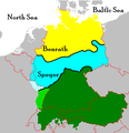
Fil:German dialectal map.PNG

Storlek på förhandsvisningen: 579 × 599 pixlar. Andra upplösningar: 232 × 240 pixlar | 629 × 651 pixlar.
Originalfil (629 × 651 pixlar, filstorlek: 16 kbyte, MIME-typ: image/png)
Filhistorik
Klicka på ett datum/klockslag för att se filen som den såg ut då.
| Datum/Tid | Miniatyrbild | Dimensioner | Användare | Kommentar | |
|---|---|---|---|---|---|
| nuvarande | 26 juli 2021 kl. 08.12 |  | 629 × 651 (16 kbyte) | E-960 | Reverted to version as of 09:41, 7 July 2021 (UTC) This is a completely different map which you uploaded! You don't just swap out an image. It's one thing to make adjustments, it another to completely replace the original image with a different one under the same file name. There's a rule against doing just that. |
| 11 juli 2021 kl. 00.36 |  | 1 245 × 744 (1,12 Mbyte) | MicBy67 | Reverted to version as of 02:06, 22 March 2021 (UTC):213 / Reason: This map shows the correct course of the Speyrer and Benrath lines as well as the former German-speaking area in the Oder-Neisse area. The previous map is extremely flawed in the course of the two isoglosses. | |
| 7 juli 2021 kl. 11.41 |  | 629 × 651 (16 kbyte) | E-960 | Reverted to version as of 02:06, 31 December 2010 (UTC) This is a completely different map. | |
| 22 mars 2021 kl. 04.06 |  | 1 245 × 744 (1,12 Mbyte) | MicBy67 | {{Information |Description=English:<br />Complete revision of the previous file.<br /> Sources: German language area and isoglosses drawn from the map "Verbreitung und Raumgliederung deutscher und niederländischer Sprache als Mundart der ländlichen Bevölkerung in Mitteleuropa um 1900“ (Distribution and spatial division of the German and Dutch languages as a dialect of the rural population in Central Europe around 1900); [https://www.regionalsprache.de Regionalssprache.de]<br /> State map and... | |
| 31 december 2010 kl. 04.06 |  | 629 × 651 (16 kbyte) | B.Bevers | Reverted to version as of 00:45, 17 February 2009 | ORIGINAL FORMAT, no German nationalism here please | |
| 4 september 2010 kl. 23.23 |  | 629 × 651 (14 kbyte) | Hans Erren | Benrath line adjusted, places added. Westward extension is reverted, frisian area excluded. Modified after Deutsche Dialekte.PNG | |
| 17 februari 2009 kl. 02.45 |  | 629 × 651 (16 kbyte) | Disposable.Heroes | pngcrush | |
| 24 december 2008 kl. 19.58 |  | 629 × 651 (29 kbyte) | Jeroen | Reverted to version as of 10:57, 1 August 2006: no source given why Dutch and Frisian is part of German; very confusing | |
| 17 november 2008 kl. 22.15 |  | 629 × 651 (29 kbyte) | Olahus | {{Information |Description= |Source= |Date= |Author= |Permission= |other_versions= }} | |
| 31 augusti 2008 kl. 16.29 |  | 629 × 651 (21 kbyte) | Trinsath | {{Information |Description= |Source= |Date= |Author= |Permission= |other_versions= }} |
Filanvändning
Inga sidor använder den här filen.
Global filanvändning
Följande andra wikier använder denna fil:
- Användande på af.wikipedia.org
- Användande på an.wikipedia.org
- Användande på ar.wikipedia.org
- Användande på bn.wikipedia.org
- Användande på ca.wikipedia.org
- Användande på el.wikipedia.org
- Användande på en.wikipedia.org
- Isogloss
- User:JALockhart
- High German consonant shift
- Category:Wikipedians in Austria
- Category:Wikipedians in Germany
- Category:Wikipedians in Luxembourg
- Category:Wikipedians in Switzerland
- Category:Austrian Wikipedians
- Category:German Wikipedians
- Wikipedia:Userboxes/Location/Germany
- Category:WikiProject Luxembourg participants
- Wikipedia:Userboxes/Location/Austria
- Category:Wikipedians interested in Germany
- Category:WikiProject Switzerland participants
- User:JALockhart/Userboxes/User int DE
- Category:WikiProject Austria participants
- User:Scriberius/Projects/Babelmania
- Category:Swiss Wikipedians
- User:Kazkaskazkasako/Books/All
- Category:Wikipedians interested in Austria
- Category:Wikipedians interested in Liechtenstein
- Category:WikiProject Liechtenstein participants
- Category:Wikipedians interested in Luxembourg
- Category:Wikipedians interested in Switzerland
- Category:Luxembourg Wikipedians
- Wikipedia:Userboxes/Education/Germany
- Template:Portal/doc/all
- Template:Noticeboard box/sandbox
- Category:German cinema task force participants
- Wikipedia:Userboxes/Location/Luxembourg
- Wikipedia:Userboxes/Location/Switzerland
- Wikipedia:Userboxes/Location/Liechtenstein
- Category:Wikipedians in Liechtenstein
- Category:Liechtenstein Wikipedians
Visa mer globalt användande av denna fil.

