
Fil:Map of Connecticut NA.png

Storlek på förhandsvisningen: 784 × 600 pixlar. Andra upplösningar: 314 × 240 pixlar | 627 × 480 pixlar | 1 004 × 768 pixlar | 1 280 × 980 pixlar | 2 015 × 1 542 pixlar.
Originalfil (2 015 × 1 542 pixlar, filstorlek: 1,86 Mbyte, MIME-typ: image/png)
| Denna fil tillhandahålls av Wikimedia Commons. Informationen nedan är kopierad från dess filbeskrivningssida. |
Sammanfattning
| Beskrivning | |
| Datum | |
| Källa | |
| Skapare | National Atlas of the United States |
| Tillstånd (Återanvändning av denna fil) |
Public domain |
Licensiering
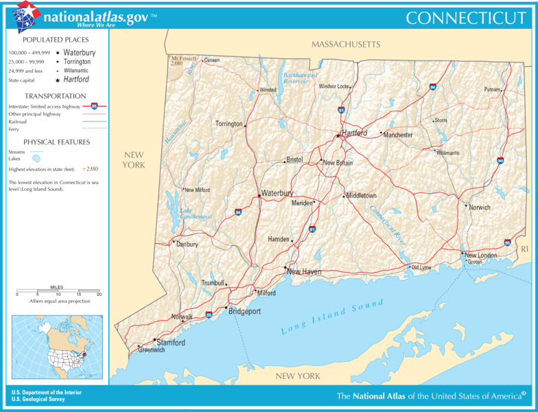
This map was obtained from an edition of the National Atlas of the United States. Like almost all works of the U.S. federal government, works from the National Atlas are in the public domain in the United States.
Online access: NationalAtlas.gov | 1970 print edition: Library of Congress, Perry-Castañeda Library
|
Filhistorik
Klicka på ett datum/klockslag för att se filen som den såg ut då.
| Datum/Tid | Miniatyrbild | Dimensioner | Användare | Kommentar | |
|---|---|---|---|---|---|
| nuvarande | 6 december 2016 kl. 00.18 | | 2 015 × 1 542 (1,86 Mbyte) | Ras67 | cropped |
| 14 augusti 2006 kl. 22.26 |  | 2 122 × 1 640 (1,96 Mbyte) | Huebi~commonswiki | {{Information| |Description=Map of Connecticut |Source=[http://www.nationalatlas.gov National Atlas] }} Category:Maps of the United States Category:Maps of Connecticut {{PD-USGov-Atlas}} |
Filanvändning
Inga sidor använder den här filen.
Global filanvändning
Följande andra wikier använder denna fil:
- Användande på da.wikipedia.org
- Användande på de.wikipedia.org
- Användande på en.wikipedia.org
- Användande på hsb.wikipedia.org
- Användande på hu.wikipedia.org
- Användande på mr.wikipedia.org
- Användande på sw.wikipedia.org
- Användande på zea.wikipedia.org