
Fil:NEO lake jau big.jpg

Storlek på förhandsvisningen: 600 × 600 pixlar. Andra upplösningar: 240 × 240 pixlar | 480 × 480 pixlar | 750 × 750 pixlar.
Originalfil (750 × 750 pixlar, filstorlek: 134 kbyte, MIME-typ: image/jpeg)
| Denna fil tillhandahålls av Wikimedia Commons. Informationen nedan är kopierad från dess filbeskrivningssida. |
Sammanfattning
| Beskrivning |
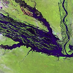
English: The Negro River flowing through the eastern edge of Brazil’s Jau National Park. The river is the big strip of blue running from left to right across the image, and the other blue ribbons are tributaries. Originating at the border of Venezuela and Brazil, the Negro River meets up with the Amazon in central Brazil to become its largest tributary. Half-submerged islands can be seen in the center of the river. Between November and April when the river is at its peak, many of these islands disappear. |
| Datum | |
| Källa |
http://earthobservatory.nasa.gov/Newsroom/NewImages/images.php3?img_id=10843
|
| Skapare | NASA and USGS EROS Data Center Satellite Systems Branch |
Licensiering
This image is in the public domain in the United States because it only contains materials that originally came from the United States Geological Survey, an agency of the United States Department of the Interior. For more information, see the official USGS copyright policy.
|
Ursprunglig uppladdningslogg
Den ursprungliga beskrivningssidan fanns här. Alla följande användarnamn finns på en.wikipedia.
- 2003-11-23 05:55 Snoyes 750×750×8 (136760 bytes)
Filhistorik
Klicka på ett datum/klockslag för att se filen som den såg ut då.
| Datum/Tid | Miniatyrbild | Dimensioner | Användare | Kommentar | |
|---|---|---|---|---|---|
| nuvarande | 4 april 2008 kl. 22.27 | | 750 × 750 (134 kbyte) | File Upload Bot (Magnus Manske) | {{BotMoveToCommons|en.wikipedia}} {{Information |Description={{en|'''Credit(s):''' [http://edc.usgs.gov/ USGS EROS Data Center] Satellite Systems Branch. '''Source:''' http://earthobservatory.nasa.gov/Newsroom/NewImages/images.php3?img_id=10843 ''?The |
Filanvändning
Följande 3 sidor använder den här filen:
Global filanvändning
Följande andra wikier använder denna fil:
- Användande på ar.wikipedia.org
- Användande på ast.wikipedia.org
- Användande på ba.wikipedia.org
- Användande på be.wikipedia.org
- Användande på bg.wikipedia.org
- Användande på ca.wikipedia.org
- Användande på de.wikipedia.org
- Användande på de.wikivoyage.org
- Användande på en.wikipedia.org
- Användande på es.wikipedia.org
- Användande på eu.wikipedia.org
- Användande på fr.wikipedia.org
- Användande på he.wikipedia.org
- Användande på he.wikivoyage.org
- Användande på hi.wikipedia.org
- Användande på hr.wikipedia.org
- Användande på id.wikipedia.org
- Användande på it.wikivoyage.org
- Användande på ja.wikipedia.org
- Användande på ka.wikipedia.org
- Användande på ko.wikipedia.org
- Användande på lt.wikipedia.org
- Användande på mai.wikipedia.org
- Användande på ml.wikipedia.org
- Användande på mt.wikipedia.org
- Användande på ne.wikipedia.org
- Användande på nl.wikipedia.org
- Användande på pl.wikipedia.org
Visa mer globalt användande av denna fil.