
Fil:Reichskanzlei-Vorbunker.png

Originalfil (1 607 × 3 514 pixlar, filstorlek: 356 kbyte, MIME-typ: image/png)
| Denna fil tillhandahålls av Wikimedia Commons. Informationen nedan är kopierad från dess filbeskrivningssida. |
| Beskrivning |
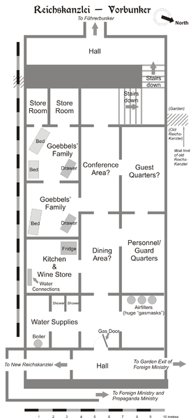
Map of the Vorbunker in Berlin, 1945. |
| Datum | |
| Källa | Eget arbete |
| Skapare | User:Dna-Dennis |
| Tillstånd (Återanvändning av denna fil) |
CC, see below. The map is completely unrestricted for any Wikipedia/Wikimedia project. |
Licensiering
- Du är fri:
- att dela – att kopiera, distribuera och sända verket
- att remixa – att skapa bearbetningar
- På följande villkor:
- erkännande – Du måste ge lämpligt erkännande, ange en länk till licensen och indikera om ändringar har gjorts. Du får göra det på ett lämpligt sätt, men inte på ett sätt som antyder att licensgivaren stödjer dig eller din användning.
Sammanfattning
This is a map of the Vorbunker in Berlin, 1945 - the "antechamber" bunker of the famous Fuehrerbunker. The layout is not necessarily perfectly exact, but it is very probable. There were two bunkers which were connected - the Fuehrerbunker and the Vorbunker, and here is the link to my map of the Fuehrerbunker, and a link to my map showing the locations of the Fuehrerbunker and Vorbunker in Berlin, 1945.
Information about the details of the bunkers is rather scarce, which is not strange, since the bunkers were secret. This map is based on the excellent research of Tom Posch (see below), who visited and photographed the remains from inside in 1988. He concluded that the map of the bunker in Cornelius Ryan's The Last Battle was incorrect, and a new, hand-drawn map of the Vorbunker was produced by Tom Posch.
Location notes
The Fuehrerbunker, built in 1944, was located 8-17 meters beneath the Reichskanzlei garden, approx. 120 meters north of the new Reichskanzlei building, which had the address Vossstrasse 6. The Führerbunker was located somewhat lower than the Vorbunker and west (or rather west-west-south) of it. The two bunkers were connected via sets of stairs set at right angles (not spiral).
Layout notes
- Particularly uncertain items are marked with question marks.
- The exact position of water & ventilation facilites and showers are uncertain.
Construction data (approximates)
- Material: Concrete
- Protective Wall Width: 220 cm
- Protective Roof Height: 280 cm
- Wall Width (interior): 15-20 cm
- Door Heights: 180-200 cm
- Door Widths: 120 cm
- Room Heights: 2-3 m
- Room Sizes: Varying; 3-5 m
References
The map is based on the following sources:
- Ramsey, Winston G. (editor) & Posch, Tom (researcher), The Berlin Führerbunker: The Thirteenth Hole, After the Battle archive copy at the Wayback Machine, No.61, Special Edition, Battle of Britain International Ltd, 1988, London
- Allied Intelligence Map of Key Buildings in Berlin (3rd edition, 1945)
- Ryan, Cornelius, The Last Battle (1966)
Regards,
Dennis Nilsson, Sweden.
If you wish to contact me, please leave a message on my talk page.

|
Denna bild (eller alla bilder i denna artikel eller kategori) bör återskapas med hjälp av vektorgrafik som en SVG-fil. Detta har flera fördelar; se Commons:Media for cleanup för mer information. Om det redan existerar en SVG-version av denna bild, var vänlig och lägg upp den. Efter att en SVG-version lagts upp, ersätt denna mall med {{vector version available|nytt bildnamn.svg}} på denna sida.
|
Filhistorik
Klicka på ett datum/klockslag för att se filen som den såg ut då.
| Datum/Tid | Miniatyrbild | Dimensioner | Användare | Kommentar | |
|---|---|---|---|---|---|
| nuvarande | 9 februari 2007 kl. 15.49 | | 1 607 × 3 514 (356 kbyte) | Dcoetzee | Remove license info and detailed description; these belong in the image description page or article; pngcrushed |
| 30 januari 2006 kl. 01.02 |  | 2 356 × 3 441 (757 kbyte) | Dna-webmaster~commonswiki | ||
| 30 januari 2006 kl. 00.27 |  | 2 357 × 3 441 (696 kbyte) | Dna-webmaster~commonswiki | == Licensing == {{self|cc-by-sa-2.5}} I hereby release this image with the following declaration: <i>Reproduction and distribution is allowed and encouraged as long as the author is acknowledged by name when this image is used.</i> == Description == T |
Filanvändning
Följande sida använder den här filen:
Global filanvändning
Följande andra wikier använder denna fil:
- Användande på ar.wikipedia.org
- Användande på br.wikipedia.org
- Användande på da.wikipedia.org
- Användande på el.wikipedia.org
- Användande på en.wikipedia.org
- Användande på es.wikipedia.org
- Användande på he.wikipedia.org
- Användande på id.wikipedia.org
- Användande på it.wikipedia.org
- Användande på ja.wikipedia.org
- Användande på ms.wikipedia.org
- Användande på nl.wikipedia.org
- Användande på no.wikipedia.org
- Användande på pt.wikipedia.org
- Användande på ru.wikipedia.org
- Användande på tr.wikipedia.org
- Användande på www.wikidata.org