
Fil:US Court of Appeals and District Court map.svg

Storleken för denna PNG-förhandsvisning av denna SVG-fil: 620 × 402 pixlar. Andra upplösningar: 320 × 207 pixlar | 640 × 415 pixlar | 1 024 × 664 pixlar | 1 280 × 830 pixlar | 2 560 × 1 660 pixlar.
Originalfil (SVG-fil, standardstorlek: 620 × 402 pixlar, filstorlek: 768 kbyte)
| Denna fil tillhandahålls av Wikimedia Commons. Informationen nedan är kopierad från dess filbeskrivningssida. |
Sammanfattning
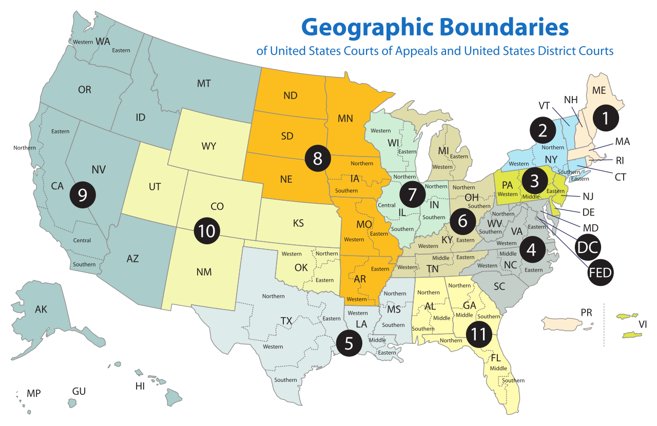
| Beskrivning | Map of the geographic boundaries of the various United States courts of appeals and United States district courts. |
| Datum | |
| Källa | http://www.uscourts.gov/uscourts/images/CircuitMap.pdf |
| Skapare | PDF by the US Government, converted using Texterity's FreeSVG, tweaked using en:Inkscape by Tintazul |
| Andra versioner |
|


Licensiering
This work is licensed by the creator under the following conditions:
Denna fil har gjorts tillgänglig under licensen Creative Commons Erkännande-Dela Lika 2.5 Generisk
- Du är fri:
- att dela – att kopiera, distribuera och sända verket
- att remixa – att skapa bearbetningar
- På följande villkor:
- erkännande – Du måste ge lämpligt erkännande, ange en länk till licensen och indikera om ändringar har gjorts. Du får göra det på ett lämpligt sätt, men inte på ett sätt som antyder att licensgivaren stödjer dig eller din användning.
- dela lika – Om du remixar, transformerar eller bygger vidare på materialet måste du distribuera dina bidrag under samma eller en kompatibel licens som originalet.
The original work from which this is derived is in the public domain for the following reason:
This image is a work of a United States Department of Justice employee, taken or made as part of that person's official duties. As a work of the U.S. federal government, the image is in the public domain (17 U.S.C. § 101 and 105).
|
 |
Filhistorik
Klicka på ett datum/klockslag för att se filen som den såg ut då.
| Datum/Tid | Miniatyrbild | Dimensioner | Användare | Kommentar | |
|---|---|---|---|---|---|
| nuvarande | 17 april 2018 kl. 20.58 | | 620 × 402 (768 kbyte) | BenbowInn | DC and FED are circuits too, added black circles to emphasize them, also converted to plain SVG |
| 11 juli 2006 kl. 09.48 |  | 620 × 402 (1,14 Mbyte) | Tintazul | {{Tintazul |Description=Map of the geographic boundaries of the various United States Courts of Appeals and United States District Courts. |Source=[http://www.uscourts.gov/image |
Filanvändning
Följande 6 sidor använder den här filen:
Global filanvändning
Följande andra wikier använder denna fil:
- Användande på ar.wikipedia.org
- Användande på bg.wikipedia.org
- Användande på bn.wikipedia.org
- Användande på ca.wikipedia.org
- Användande på cs.wikipedia.org
- Användande på da.wikipedia.org
- Användande på de.wikipedia.org
- Användande på en.wikipedia.org
- Federal jurisdiction (United States)
- United States courts of appeals
- United States district court
- United States federal judicial district
- United States Court of Appeals for the Ninth Circuit
- United States Court of Appeals for the Eighth Circuit
- Case citation
- List of regions of the United States
- United States Court of Appeals for the First Circuit
- United States Court of Appeals for the Second Circuit
- United States Court of Appeals for the Third Circuit
- United States Court of Appeals for the Fourth Circuit
- United States Court of Appeals for the Fifth Circuit
- United States Court of Appeals for the Sixth Circuit
- United States Court of Appeals for the Seventh Circuit
- United States Court of Appeals for the Tenth Circuit
- United States Court of Appeals for the Eleventh Circuit
- United States Attorney
- United States Court of Appeals for the District of Columbia Circuit
- Circuit court
- United States District Court for the Southern District of New York
- United States District Court for the Eastern District of Virginia
- United States District Court for the Eastern District of Pennsylvania
- United States District Court for the Central District of California
- List of former United States district courts
- United States District Court for the Western District of New York
- United States District Court for the Eastern District of New York
- United States District Court for the Northern District of New York
- United States District Court for the Middle District of Alabama
- United States District Court for the Southern District of Alabama
- United States District Court for the Northern District of Alabama
- United States District Court for the Southern District of California
- United States District Court for the Southern District of Florida
- United States District Court for the Northern District of California
- United States District Court for the Northern District of Oklahoma
Visa mer globalt användande av denna fil.