
Fil:Vredefort.jpg

Storlek på förhandsvisningen: 800 × 600 pixlar. Andra upplösningar: 320 × 240 pixlar | 640 × 480 pixlar | 1 024 × 768 pixlar.
Originalfil (1 024 × 768 pixlar, filstorlek: 266 kbyte, MIME-typ: image/jpeg)
| Denna fil tillhandahålls av Wikimedia Commons. Informationen nedan är kopierad från dess filbeskrivningssida. |
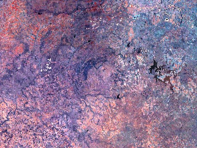
| Beskrivning | Vredefort crater has a diameter of 300 km, and its circular structure nearly fills the complete image. The Vredefort dome, a conspicuous geologic feature about 50 km in diameter, stands out at the center. |
| Källa | Created with NASA WorldWind by User:Vesta using Landsat 7 (Visible Color) satellite image. |
| Skapare | User:Vesta |
27°0′0″S 27°30′0″E / 27°S 27.5°E
| This image is in the public domain because it is a screenshot from NASA’s globe software World Wind using a public domain layer, such as Blue Marble, MODIS, Landsat, SRTM, USGS or GLOBE.
|
 |
Filhistorik
Klicka på ett datum/klockslag för att se filen som den såg ut då.
| Datum/Tid | Miniatyrbild | Dimensioner | Användare | Kommentar | |
|---|---|---|---|---|---|
| nuvarande | 7 januari 2006 kl. 11.12 | | 1 024 × 768 (266 kbyte) | Vesta~commonswiki | * '''Description:''' Vredefort crater has a diameter of 300 km, and its circular structure nearly fills the complete image. The Vredefort ring, a conspicuous feature, 50 km in diameter, stands out at the center. *'''Source:''' Created with NASA WorldWind |
Filanvändning
Följande 2 sidor använder den här filen:
Global filanvändning
Följande andra wikier använder denna fil:
- Användande på avk.wikipedia.org
- Användande på be.wikipedia.org
- Användande på de.wikipedia.org
- Användande på de.wikivoyage.org
- Användande på es.wikipedia.org
- Användande på hr.wikipedia.org
- Användande på hy.wikipedia.org
- Användande på it.wikipedia.org
- Användande på lt.wikipedia.org
- Användande på ml.wikipedia.org
- Användande på pt.wikipedia.org
- Användande på ru.wikipedia.org
- Användande på sh.wikipedia.org