
Fil:WorldMapCosmasIndicopleustes.jpg
Originalfil (1 539 × 1 208 pixlar, filstorlek: 654 kbyte, MIME-typ: image/jpeg)
| Denna fil tillhandahålls av Wikimedia Commons. Informationen nedan är kopierad från dess filbeskrivningssida. |
Sammanfattning
| Beskrivning |
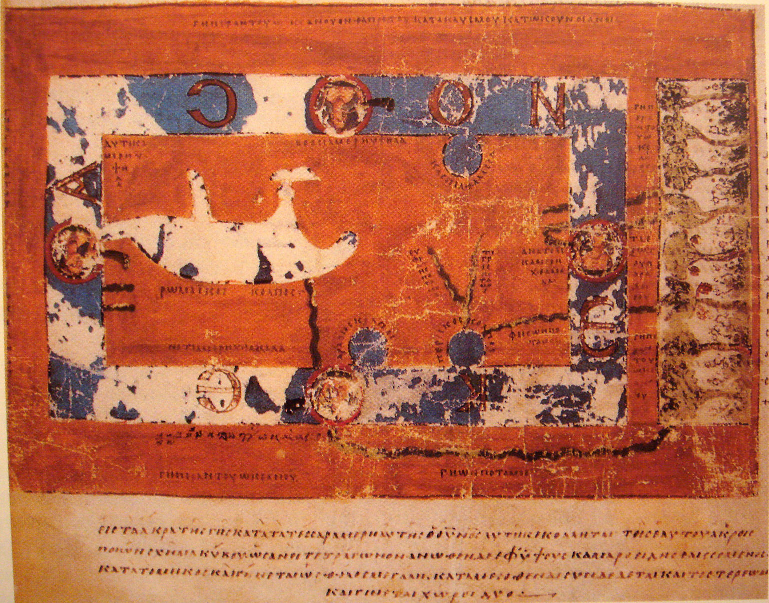
World Map by Cosmas Indicopleustes. The map is oriented with north to the top. It shows a rectangular landmass in the middle of the World Ocean ( ꙌΚΕΑΝΟϹ , Okeanos), reflecting what Cosmas thought was the "floor" of the tabernacle-shaped universe. The Roman Gulf (i.e., Mediterranean) is shown in the western half, with indentations for the unmarked Adriatic and Aegean/Black seas. Three further gulfs are shown: the Caspian to the northeast and the Arabian (i.e., Red Sea) and Persian gulfs to the south. Paradise is shown in the far east, beyond the Ocean. Four rivers run from it and cross under or through the Ocean to reach Asia and Africa. |
| Datum | 6th century map. |
| Källa | "Les Sciences au Moyen-Age", "Pour la Science" |
| Skapare | Cosmas Indicopleustes, 6th century |
| Andra versioner |
|

Licensiering
|
Denna bild avbildar ett tvådimensionellt konstverk. Konstverket är självt i public domain av följande anledning:
Reproduktioner av tvådimensionella verk får inte egen upphovsrätt i USA enligt domen i Bridgeman Art Library v. Corel Corp. Wikimedia Foundation anser att en annan tolkning av upphovsrätten skulle innebära ett angrepp på begreppet ”public domain”, varför också denna fotografiska avbildning bör anses vara i ”public domain”. Se Commons:When to use the PD-Art tag#Other countries. Märk att lokala lagar kan hindra användande av bilden. Se Commons:Reuse of PD-Art photographs. {{PD-Art}} template without license parameter: please specify why the underlying work is public domain in both the source country and the United States
(Usage: {{PD-Art|1=|deathyear=''year of author's death''|country=''source country''}}, where parameter #1 can be PD-old-auto, PD-old-auto-expired, PD-old-auto-1996, PD-old-100 or similar. See Commons:Multi-license copyright tags for more information.) | ||||
| Annotations | This image is annotated: View the annotations at Commons |
Filhistorik
Klicka på ett datum/klockslag för att se filen som den såg ut då.
| Datum/Tid | Miniatyrbild | Dimensioner | Användare | Kommentar | |
|---|---|---|---|---|---|
| nuvarande | 16 november 2007 kl. 20.33 | | 1 539 × 1 208 (654 kbyte) | World Imaging | {{Information |Description=World Map by Cosmas Indicopleustes |Source="Les Sciences au Moyen-Age", "Pour la Science" |Date=6th century map. |Author=Cosmas Indicopleustes, 6th century |Permission= |other_versions= }} |
Filanvändning
Följande sida använder den här filen:
Global filanvändning
Följande andra wikier använder denna fil:
- Användande på ar.wikipedia.org
- Användande på ca.wikipedia.org
- Användande på ceb.wikipedia.org
- Användande på de.wikipedia.org
- Användande på el.wikipedia.org
- Användande på en.wikipedia.org
- Användande på eo.wikipedia.org
- Användande på es.wikipedia.org
- Användande på fa.wikipedia.org
- Användande på fa.wikibooks.org
- Användande på fi.wikipedia.org
- Användande på fr.wikipedia.org
- Användande på gl.wikipedia.org
- Användande på he.wikipedia.org
- Användande på hr.wikipedia.org
- Användande på id.wikipedia.org
- Användande på it.wikipedia.org
- Användande på it.wikiquote.org
- Användande på ja.wikipedia.org
- Användande på ka.wikipedia.org
- Användande på la.wikipedia.org
- Användande på nl.wikipedia.org
- Användande på pl.wikipedia.org
Visa mer globalt användande av denna fil.