
Fil:AF447SeaBottom.jpg

Storlek på förhandsvisningen: 673 × 599 pixlar. Andra upplösningar: 270 × 240 pixlar | 539 × 480 pixlar | 863 × 768 pixlar | 1 150 × 1 024 pixlar | 2 300 × 2 048 pixlar | 2 808 × 2 500 pixlar.
Originalfil (2 808 × 2 500 pixlar, filstorlek: 4,16 Mbyte, MIME-typ: image/jpeg)
| Denna fil tillhandahålls av Wikimedia Commons. Informationen nedan är kopierad från dess filbeskrivningssida. |
Sammanfattning
| Beskrivning |
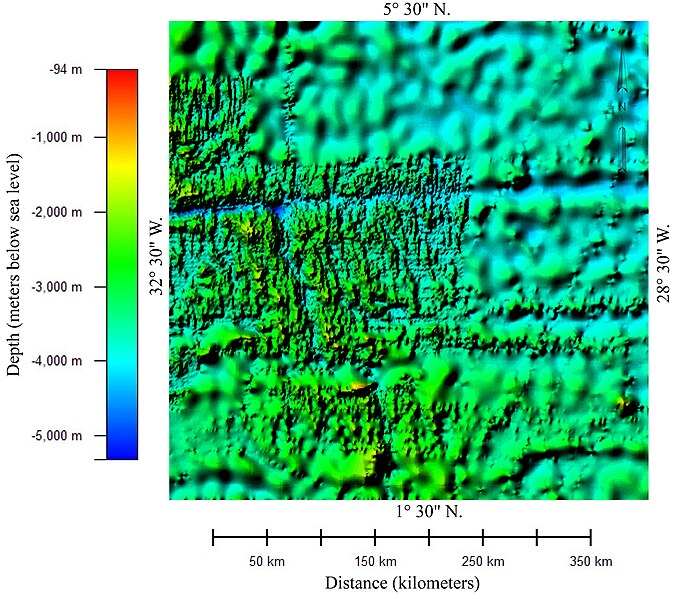
English: Color relief map of the bathymetry of the part of Atlantic Ocean in which Air France Flight 447 crashed. The image shows two different data sets with different resolution. The areas showing detailed bathymetry were mapped using multibeam bathmetry sonar. The areas showing very generalized bathmetry were mapped using high-density satellite altimetry.
This image was prepared from General Bathymetric Chart of the Oceans (GEBCO) compiled by the British Oceanographic Centre. The 30 arc-second gridded bathymetric data was downloaded from "Gridded bathymetric data sets" at http://www.bodc.ac.uk/data/online_delivery/gebco/. Image was prepared using Global Mapper 8.0 and Adobe Illustrator CS2.
Esperanto: La kolora reliefa mapo de batimetrio de la parto de la Atlantiko kie kraŝis la Flugo Air France 447.
Français : Relief bathymétrique en couleur de la portion de l'océan Atlantique dans laquelle a disparu le vol Air France 447. L'image montre deux ensembles de données avec des résolutions différentes. Les zones de bathymétrie de détail ont été cartographiées à l'aide d'un sonar multifaisceaux. Les zones montrant la bathymétrie d'ensemble ont été relevées par un radar altimétrique de haute précision embarqué sur un satellite.
Português: Um mapa batimétrico de parte do Oceano Atlântico na região onde o Voo Air France 447 desapareceu. A imagem mostra dois conjuntos distintos de dados com resoluções diferentes. A área que mostra a batimetria detalhada, mais nítida, foi feita utilizando sonares batimétricos. A área mostrando dados batimétricos mais generalizados foram feitos utilizando satélites altimétricos de alta densidade. Este mapa foi preparado com base na Tabela Geral Batimétrica dos Oceanos (GEBCO, da sigla em inglês) feita pelo Centro Britânico de Oceanografia. Os dados foram gravados de http://www.bodc.ac.uk/data/online_delivery/gebco/. A imagem foi feita utilizando o software Global Mapper 8.0 e o Adobe Illustrator CS2.
Deutsch: Bathymetrie eines Teil des Atlaniks mit der möglichen Absturzstelle des Flugzeuges des Fluges Air France 447. Durch Sonarabtastung des Meeresbodens druch Satelliten entand diese Reliefkarte unter Zugrundelgung des General Bathymetric Chart of the Oceans [GEBCO] des British Oceanographic Centre. |
| Datum | |
| Källa | Eget arbete |
| Skapare | Paradoxides |
Licensiering
Jag, upphovsrättsinnehavaren av detta verk, publicerar härmed det under följande licenser:
Denna fil har gjorts tillgänglig under licensen Creative Commons Erkännande-Dela Lika 3.0 Generisk
- Du är fri:
- att dela – att kopiera, distribuera och sända verket
- att remixa – att skapa bearbetningar
- På följande villkor:
- erkännande – Du måste ge lämpligt erkännande, ange en länk till licensen och indikera om ändringar har gjorts. Du får göra det på ett lämpligt sätt, men inte på ett sätt som antyder att licensgivaren stödjer dig eller din användning.
- dela lika – Om du remixar, transformerar eller bygger vidare på materialet måste du distribuera dina bidrag under samma eller en kompatibel licens som originalet.

|
Tillstånd ges att kopiera, distribuera och/eller modifiera detta dokument under villkoren i GNU Free Documentation License, Version 1.2 eller senare version publicerad av Free Software Foundation, utan oföränderliga avsnitt, framsidestexter eller baksidestexter. En kopia av licensen ingår i avsnittet GNU Free Documentation License. |
Du får själv välja den licens du vill använda.
Filhistorik
Klicka på ett datum/klockslag för att se filen som den såg ut då.
| Datum/Tid | Miniatyrbild | Dimensioner | Användare | Kommentar | |
|---|---|---|---|---|---|
| nuvarande | 6 juni 2009 kl. 06.05 | | 2 808 × 2 500 (4,16 Mbyte) | Paradoxides~commonswiki | Replaced previous image because longitude text clipped on right edge. |
| 6 juni 2009 kl. 04.44 |  | 2 803 × 2 500 (4,16 Mbyte) | Paradoxides~commonswiki | Added captions to clarify scales on mmap | |
| 6 juni 2009 kl. 04.29 |  | 1 311 × 1 198 (1,81 Mbyte) | Paradoxides~commonswiki | {{Information |Description={{en|1=Color relief map of the bathymetry of the part of Atlantic Ocean in which Air France Flight crashed. The image shows two different data sets with different resolution. The areas showing detailed bathymetry were mapped usi |
Filanvändning
Följande sida använder den här filen:
Global filanvändning
Följande andra wikier använder denna fil:
- Användande på de.wikipedia.org
- Användande på en.wikipedia.org
- Användande på eo.wikipedia.org
- Användande på fr.wikipedia.org
- Användande på www.wikidata.org