
Fil:ElectoralCollege2000-Large.png
Storlek på förhandsvisningen: 800 × 430 pixlar. Andra upplösningar: 320 × 172 pixlar | 640 × 344 pixlar | 1 182 × 635 pixlar.
Originalfil (1 182 × 635 pixlar, filstorlek: 175 kbyte, MIME-typ: image/png)
| Denna fil tillhandahålls av Wikimedia Commons. Informationen nedan är kopierad från dess filbeskrivningssida. |
| U.S. presidential election maps from the National Atlas of the United States |
| See also: SVG maps |
| 1789 · 1792 · 1796 · 1800 · 1804 · 1808 · 1812 · 1816 · 1820 · 1824 · 1828 · 1832 · 1836 · 1840 · 1844 · 1848 · 1852 · 1856 · 1860 · 1864 · 1868 · 1872 · 1876 · 1880 · 1884 · 1888 · 1892 · 1896 · 1900 · 1904 · 1908 · 1912 · 1916 · 1920 · 1924 · 1928 · 1932 · 1936 · 1940 · 1944 · 1948 · 1952 · 1956 · 1960 · 1964 · 1968 · 1972 · 1976 · 1980 · 1984 · 1988 · 1992 · 1996 · 2000 · 2004 |
Sammanfattning
| Beskrivning |
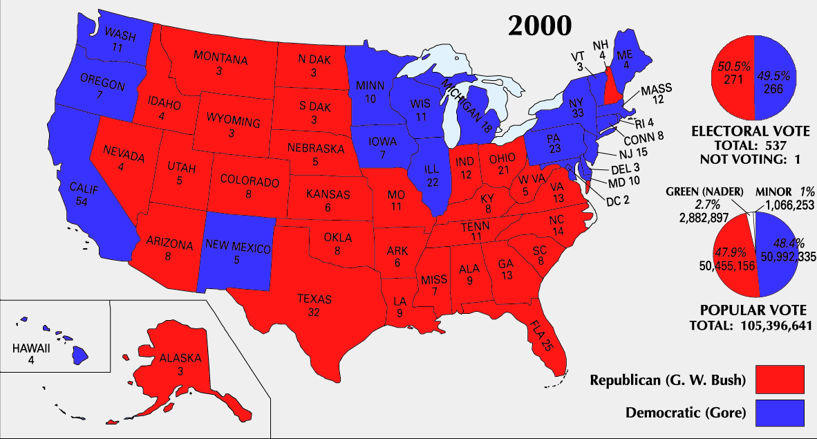
English: 2000 Electoral College Map |
|||
| Källa | https://nationalmap.gov/small_scale/printable/elections.html | |||
| Skapare | United States Geological Survey | |||
| Andra versioner |
|


Licensiering
This map was obtained from an edition of the National Atlas of the United States. Like almost all works of the U.S. federal government, works from the National Atlas are in the public domain in the United States.
Online access: NationalAtlas.gov | 1970 print edition: Library of Congress, Perry-Castañeda Library
|
Filhistorik
Klicka på ett datum/klockslag för att se filen som den såg ut då.
| Datum/Tid | Miniatyrbild | Dimensioner | Användare | Kommentar | |
|---|---|---|---|---|---|
| nuvarande | 26 juni 2008 kl. 01.51 | | 1 182 × 635 (175 kbyte) | Tallicfan20 | better resolution |
| 14 februari 2008 kl. 03.02 |  | 1 182 × 635 (83 kbyte) | SteveSims~commonswiki | Reverted to version as of 10:23, 25 July 2007. The version with Nader as green didn't look very good. | |
| 8 februari 2008 kl. 00.08 |  | 1 182 × 635 (2,15 Mbyte) | SteveSims~commonswiki | Ralph Nader's popular votes made green. Also public domain. | |
| 25 juli 2007 kl. 12.23 |  | 1 182 × 635 (83 kbyte) | Cardsplayer4life~commonswiki | Reverted to earlier revision | |
| 25 juli 2007 kl. 11.46 |  | 1 182 × 635 (62 kbyte) | Joseph Solis in Australia~commonswiki | {{PD-USGov-Atlas}} Category:2000 {{US presidential election maps}} | |
| 2 juli 2007 kl. 04.30 |  | 1 182 × 635 (83 kbyte) | Cardsplayer4life~commonswiki | {{PD-USGov-Atlas}} Source: EN Wiki {{US presidential election maps}} | |
| 29 juni 2007 kl. 12.08 |  | 1 182 × 635 (62 kbyte) | Joseph Solis in Australia~commonswiki | {{PD-USGov-Atlas}} Category:2000 {{US presidential election maps}} | |
| 21 juni 2007 kl. 23.04 |  | 1 182 × 635 (83 kbyte) | Cardsplayer4life~commonswiki | {{PD-USGov-Atlas}} Category:2000 {{US presidential election maps}} | |
| 19 augusti 2005 kl. 12.21 |  | 1 182 × 635 (62 kbyte) | Ondrejk | {{PD-USGov-Atlas}} Source: EN Wiki |
Filanvändning
Följande 2 sidor använder den här filen:
Global filanvändning
Följande andra wikier använder denna fil:
- Användande på el.wikipedia.org
- Användande på en.wikipedia.org
- Användande på fa.wikipedia.org
- Användande på uk.wikipedia.org