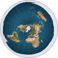
Fil:Flat earth.png
Flat_earth.png (543 × 543 pixlar, filstorlek: 396 kbyte, MIME-typ: image/png)
Filhistorik
Klicka på ett datum/klockslag för att se filen som den såg ut då.
| Datum/Tid | Miniatyrbild | Dimensioner | Användare | Kommentar | |
|---|---|---|---|---|---|
| nuvarande | 25 augusti 2012 kl. 03.33 |  | 543 × 543 (396 kbyte) | AnonMoos | Reverted to version as of 17:17, 12 December 2008 |
| 25 augusti 2012 kl. 01.30 |  | 543 × 543 (402 kbyte) | Rotatebot | Bot: Image rotated by 180° | |
| 12 december 2008 kl. 19.17 |  | 543 × 543 (396 kbyte) | MathiasRav | {{Information |Description={{en|I made this map myself by creating an azimuthal projection of the entire Earth. A rendered picture of the Flat Earth model. The white around the outside of the globe is an 'Ice Wall', preventing people from falling off the |
Filanvändning
Inga sidor använder den här filen.
Global filanvändning
Följande andra wikier använder denna fil:
- Användande på ar.wikipedia.org
- Användande på ce.wikipedia.org
- Användande på cs.wikipedia.org
- Användande på cv.wikipedia.org
- Användande på de.wikipedia.org
- Användande på de.wikivoyage.org
- Användande på eml.wikipedia.org
- Användande på en.wikipedia.org
- Användande på et.wikipedia.org
- Användande på eu.wikipedia.org
- Användande på fa.wikipedia.org
- Användande på fr.wikipedia.org
- Användande på he.wikipedia.org
- Användande på hy.wikipedia.org
- Användande på inh.wikipedia.org
- Användande på ja.wikipedia.org
- Användande på jv.wikipedia.org
- Användande på ko.wikipedia.org
- Användande på ms.wikipedia.org
- Användande på nl.wikipedia.org
- Användande på pl.wikipedia.org
- Användande på pt.wikipedia.org
- Användande på ru.wikipedia.org
- Användande på uk.wikipedia.org
- Användande på www.wikidata.org
- Användande på zh.wikipedia.org

