
Fil:Map of USA AK full.png
Det finns ingen version med högre upplösning.
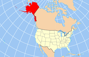
Map_of_USA_AK_full.png (284 × 184 pixlar, filstorlek: 19 kbyte, MIME-typ: image/png)
| Denna fil tillhandahålls av Wikimedia Commons. Informationen nedan är kopierad från dess filbeskrivningssida. |

|
Det finns en vektorversion av denna rasterbild (SVG).
När vektorbilden är lämpligare ska den användas istället för rasterbilden. File:Map of USA AK full.png → File:Map of USA AK full.svg
För mer information om vektorgrafik, se artikeln Commons transition to SVG (på engelska). |
 |
Sammanfattning
| Beskrivning | Map of USA with Alaska highlighted and shown in true position |
| Datum | |
| Källa | http://www.nationalatlas.gov/printable/reference.html |
| Skapare | |
| Andra versioner | File:Map of USA AK full.svg |
Licensiering
This map was obtained from an edition of the National Atlas of the United States. Like almost all works of the U.S. federal government, works from the National Atlas are in the public domain in the United States.
Online access: NationalAtlas.gov | 1970 print edition: Library of Congress, Perry-Castañeda Library
|
Filhistorik
Klicka på ett datum/klockslag för att se filen som den såg ut då.
| Datum/Tid | Miniatyrbild | Dimensioner | Användare | Kommentar | |
|---|---|---|---|---|---|
| nuvarande | 17 december 2012 kl. 22.43 | | 284 × 184 (19 kbyte) | Ras67 | cropped |
| 2 april 2007 kl. 18.31 |  | 286 × 186 (20 kbyte) | MattWright | fix to more standard map colors | |
| 2 april 2007 kl. 08.20 |  | 286 × 186 (19 kbyte) | MattWright | {{Information |Description=Map of USA with Alaska highlighted and shown in true position |Source=http://www.nationalatlas.gov/printable/reference.html |Date=2007-04-02 |Author= |Permission= |other_versions= }} Category:Maps of the United States [[Cat |
Filanvändning
Följande 16 sidor använder den här filen:
- Aleutians East Borough
- Anchorage
- Bristol Bay Borough
- Denali Borough
- Fairbanks North Star Borough
- Haines Borough
- Kenai Peninsula Borough
- Ketchikan Gateway Borough
- Kodiak Island Borough
- Lake and Peninsula Borough
- Matanuska-Susitna Borough
- North Slope Borough
- Northwest Arctic Borough
- Skagway
- Wrangell
- Yakutat
Global filanvändning
Följande andra wikier använder denna fil:
- Användande på am.wikipedia.org
- Användande på ar.wikipedia.org
- Användande på az.wikipedia.org
- Användande på az.wiktionary.org
- Användande på ba.wikipedia.org
- Användande på bn.wikipedia.org
- Användande på ce.wikipedia.org
- Användande på cy.wikipedia.org
- Användande på da.wikipedia.org
- Användande på de.wikipedia.org
- Användande på el.wikipedia.org
- Användande på en.wikipedia.org
- Användande på es.wikibooks.org
- Användande på fa.wikipedia.org
- Användande på fr.wikinews.org
- Användande på ga.wikipedia.org
- Sitka
- Buirg Aleutians Thoir, Alasca
- Buirg Anchorage, Alasca
- Buirg Artach Thiar Thuaidh, Alasca
- Buirg Bristol Bay, Alasca
- Buirg Denali, Alasca
- Buirg Fairbanks Réalta Thuaidh, Alasca
- Buirg Haines, Alasca
- Buirg Juneau, Alasca
- Buirg Leithinis Kenai, Alasca
- Buirg Tairseach Ketchikan, Alasca
- Buirg Oileán Kodiak, Alasca
- Buirg Loch agus Leithinis, Alasca
- Buirg Matanuska-Susitna, Alasca
Visa mer globalt användande av denna fil.