
Fil:NorthAmerica1763-A.png
Det finns ingen version med högre upplösning.
NorthAmerica1763-A.png (787 × 600 pixlar, filstorlek: 43 kbyte, MIME-typ: image/png)
| Denna fil tillhandahålls av Wikimedia Commons. Informationen nedan är kopierad från dess filbeskrivningssida. |
Sammanfattning
| Beskrivning |
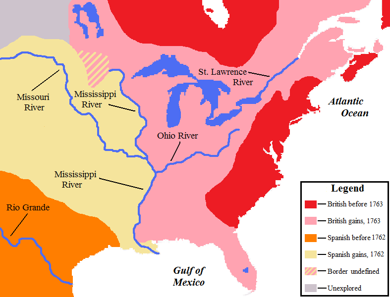
English: Map showing the North American territorial gains of Spain in 1762 and Britain in 1763. |
| Datum | |
| Källa | Own work by uploader, base map used is found here, uploaded by User:Roke |
| Skapare | AlexiusHoratius |
Licensiering
Jag, upphovsrättsinnehavaren av detta verk, publicerar härmed det under följande licenser:
Denna fil har gjorts tillgänglig under licensen Creative Commons Erkännande-Dela Lika 3.0 Unported
- Du är fri:
- att dela – att kopiera, distribuera och sända verket
- att remixa – att skapa bearbetningar
- På följande villkor:
- erkännande – Du måste ge lämpligt erkännande, ange en länk till licensen och indikera om ändringar har gjorts. Du får göra det på ett lämpligt sätt, men inte på ett sätt som antyder att licensgivaren stödjer dig eller din användning.
- dela lika – Om du remixar, transformerar eller bygger vidare på materialet måste du distribuera dina bidrag under samma eller en kompatibel licens som originalet.

|
Tillstånd ges att kopiera, distribuera och/eller modifiera detta dokument under villkoren i GNU Free Documentation License, Version 1.2 eller senare version publicerad av Free Software Foundation, utan oföränderliga avsnitt, framsidestexter eller baksidestexter. En kopia av licensen ingår i avsnittet GNU Free Documentation License. |
Du får själv välja den licens du vill använda.
Notes
- The pink coloring specifically designates territory that Britain held without question after 1763; included are both areas that had been under full Spanish or French control and then lost, as well as areas disputedly claimed by Britain before 1763.
- Florida was held by Spain prior to 1763; on the map it is shown only as a British gain, and appears no different from territory lost by France.
- The undefined boundary in the upper watershed of the Red River of the North was due to confusion at the time as to the location of the headwaters of the Mississippi River. (The source of the Mississippi was believed to have been further north than its actual location.)
Filhistorik
Klicka på ett datum/klockslag för att se filen som den såg ut då.
| Datum/Tid | Miniatyrbild | Dimensioner | Användare | Kommentar | |
|---|---|---|---|---|---|
| nuvarande | 26 september 2008 kl. 02.16 | | 787 × 600 (43 kbyte) | AlexiusHoratius~commonswiki | {{Information |Description={{en|1=Map showing the territorial gains by Britain and Spain in North America in 1762 and 1763.}} |Source=Own work by uploader |Author=AlexiusHoratius |Date=25 September 2008 |Permission= |other_version |
Filanvändning
Följande sida använder den här filen:
Global filanvändning
Följande andra wikier använder denna fil:
- Användande på en.wikipedia.org
- Användande på mt.wikipedia.org