Fil:African-civilizations-map-pre-colonial.svg
Sidans innehåll stöds inte på andra språk.
Från Wikipedia

Originalfil(SVG-fil, standardstorlek: 1 390 × 1 295 pixlar, filstorlek: 488 kbyte)

 
W3C-validity not checked.

Sammanfattning

Beskrivning

Africa History Atlas

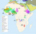
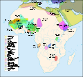
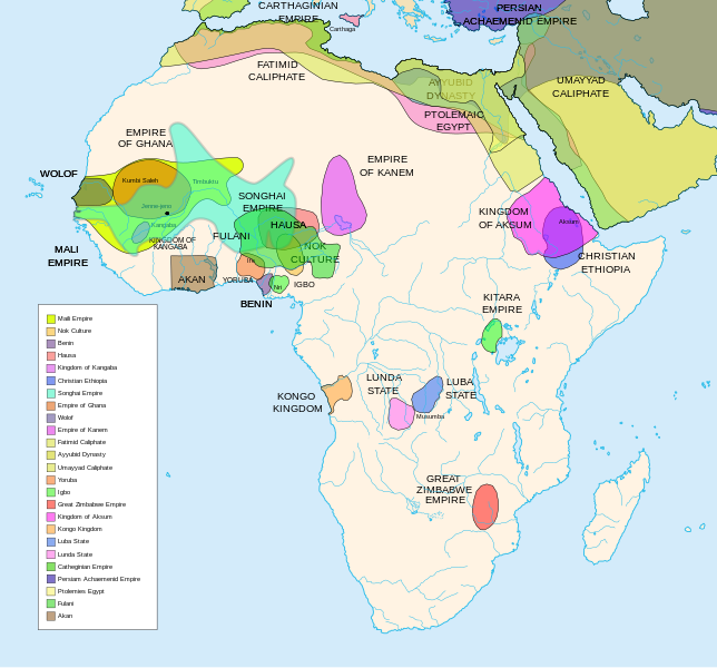
Diachronic map showing pre-colonial cultures of Africa (spanning roughly 500 BCE to 1500 CE)

This map is "an artistic interpretation" using multiple and disparate sources.
Datum
Källa Eget arbete
Skapare Jeff Israel (ZyMOS)
Andra versioner

Derivative works of this file:  African-civilizations-map-imperial.png

Civilizations

These civilizations are shown on the map above

Mali Empire (done):
        [4], [5], [6], [7], [8](1300), 14

Nok Culture(done):
        http://perso.orange.fr/miltiade/Civilisation_de_Nok.htm
        [5]

Fulani empire (aka sokoto empire, Sokoto Calphate, Fulani Empire of Sokoto)  (fulani people are different) (done):
        [2], [10e], [11e]
Akan States (generric term for states with the akan people)(Done): 
 [7], 
Benin: (done)
        [7],[14],[16]
Hausa (done)
        [7], [10],[16]

Kingdon of Kangaba (1000AD?) (done)
        [8](1235)

Christian Ethiopia(done)
        [5]

Songhai Empire (done)
        http://commons.wikimedia.org/wiki/Image:Mapa_shonghai.svg
        [3], [4], [5], [6], [7], [8](1300), [16]
        http://www.zum.de/whkmla/histatlas/westafrica/haxmali.html
        http://empathosnationenterprises.com/Consulate/EN-Library/Black-Studies/afempire.html

Empire of Ghana (done):
        [4], [5], [6], [7]

Wolof: (15th century) (done)
        [2],[2c],[14]

Empire of Kanem:(done)
        [15]

Fatimid caliphate(done) 909-1171AD
        [2b],[6b]

Ayyubid dynasty (done) 1171-1250ad
        [1b], [5e], [6e]

Umayyad Caliphate (done) 661-750
        [5b]

Yoruba yorubaland    (done)
        [4b],[2c]

Igbo    (done)
        [4b],

Great Zimbabwe (done):
        [5], [7]

Kingdom of aksum (Axum?) 1bc-7ad  (done)
        [12b],[14b],[15b]

Kongo Kingdom     (done)
        [1c], [2c],[15]

Luba State (done) 15-19th century
        [2c],[4c]

Lunda State (done) 15-19th century
        [2c],[4c],[16]

Carthaginian Empire(done) (220BCE) Carthage
        [2c], [3c]

Persian Achaemenid Empire (done)
        [2e],3e].4e],[

THE PTOLEMIES (done)
        [8e], [9e]

Civilizations to be added

These civilizations have not been added because the borders have not yet been confirmed, or there is some uncertainty if they are a true civilization. Please add them to the map if you are able to define the borders of these civilizations.


Mane (1000-2000)(city) [41]

Kano (independent city-state) (1000-1903):
 [14]

Kaarta (kingdom of Kaarta) (1753-1854):
 [14]

Macina (Macina Empire) (aka Dina of Massina, Sise Jihad state, and Caliphate of Hamdullahi) (1818-1862):
 [14]

Segou (city 1620):
 [14]

Kingdom of Fouta Djallon (Futa Djalon or Kingdom of Fuuta Jallon):
 [14]

Hausa Bakwai (initial stage Hausa):
 [11e]

Wassoulou Empire (Ouassoulou) (1878 - 1898) :
 [14]

Kénédougou Kingdom (Kenedougou) (1650-1898):
 [14]

Ouagadougou (15th century CITY):
 [14]

Ashanti Kingdom:
	[14]

Dahomey:
	[14]

Gando (16th century town):
	[14]

kingdom of Takrur (c. 800 - c. 1285) :
	[8](1300), [13]

Oyo empire (1400-1796)


Bornu Empire (1396-1893):
        [2],[15], [10e]

Bornu-Kanem (a portion of kanem history where they merged):
	[7],[2c]

Wodaabe (a people of africa):
	[10]

Mamluk Sultanate of Egypt (1174-1820):
	[2],[12], 

Kush?Kushite kingdom?:

Axum (see kingdom of aksum):

Buganda kingdom (changed to Unganda, but remained as Buganda people):

Lozi???:

Malawi Empire (late 15th centure and converted to Malawi Contry):

Kilwa (Kilwa Kisiwani, 9th century,  is an Islamic community is present day tanzania):
	[2c]

Abyssinia???:
        [2], [7]

Soha????:
        [2],

Nubia (Makuria, Nobatia, Alodia kingdom):
	[7], 

Kingdom of Kerma(2500BC-1520BC):

=North Central=

Sahariano??:
	[1], 

Maban????????:
        [1],

Fur(a people:
        [1],

Sudanes Central (language Central Sudanic):
        [1],

=East Central=

Sudanes Meridional???:
        [1],

Berta(language>:
        [1],

Kunama(a people):
        [1],

Komuz???instument:
        [1],

Aksumite Civilization
	[7b], [9b(maybey], [13b(aksum)]

Kingdom of Sheva???
	[8b]

Egypt
	[10b]

JolofEmpire (also called Dyolof or Wolof), wolof should be changed to this:
	[11b]


Meroe(city, capital of Kushitic Kingdom)) 
	[12b]

Bantu(ethnic group)
	[12b]

Khoisan(ethnic group)
	[12b]

Almoravid Empire
	[5c], [1f]
	
Monomotapa
	[2c],[16]

Lozi
	[2c]

Zulu Kingdom
	[2c]

Merina
	[2c]

Malawi
	[2c]

Rawanda
	[2c]

Buganada
	[2c]

Kazembe
	[4c]


Punt (3000BC-1000BC):
	location lost in time

D'mt (800BC-100BC):


Gudit (1000AD):

Zagwe Dynasty (1000-1268AD):
	[6e]
	
Solomonic dynasty (1270-1974AD)

Himyar:
	[1d]

Qataban:
	[1d]

Saba:
	[1d]

Hadhramaut:
	[1d]

Thutmoses 1
	[1e]

Ramesses II
	[1e]

Assurbanipal, empire of 
	[7e]

Mbunda Kingdom
	[12e], [13e]

Editing this page and map

Suggestions before editing this map: Be sure to confirm it with multiple sources, and that it would be considered a true civilization. Also if you add to the map please name the layers and objects to keep it organized. A lot of the civilizations on this page do not have the times they existed. If this could be added it would be very beneficial. Then the map could be easily split into eras.

References

The original map came from


Licensiering

Jag, upphovsrättsinnehavaren av detta verk, publicerar härmed det under följande licenser:
GNU head Tillstånd ges att kopiera, distribuera och/eller modifiera detta dokument under villkoren i GNU Free Documentation License, Version 1.2 eller senare version publicerad av Free Software Foundation, utan oföränderliga avsnitt, framsidestexter eller baksidestexter. En kopia av licensen ingår i avsnittet GNU Free Documentation License.
w:sv:Creative Commons
erkännande dela lika
Denna fil har gjorts tillgänglig under licenserna Creative Commons Erkännande-DelaLika 3.0 Unported, 2.5 Generisk, 2.0 Generisk och 1.0 Generisk.
Du är fri:
  • att dela – att kopiera, distribuera och sända verket
  • att remixa – att skapa bearbetningar
På följande villkor:
  • erkännande – Du måste ge lämpligt erkännande, ange en länk till licensen och indikera om ändringar har gjorts. Du får göra det på ett lämpligt sätt, men inte på ett sätt som antyder att licensgivaren stödjer dig eller din användning.
  • dela lika – Om du remixar, transformerar eller bygger vidare på materialet måste du distribuera dina bidrag under samma eller en kompatibel licens som originalet.
Du får själv välja den licens du vill använda.

Bildtexter

Ingen bildtext har definierats
Map of pre-colonial African civilizations

Objekt som porträtteras i den här filen

motiv

image/svg+xml

458dcae2fb4eb4a66837ee9cd5c1e539750e7c18

498 775 byte

1 295 pixel

1 390 pixel

Filhistorik

Klicka på ett datum/klockslag för att se filen som den såg ut då.

(nyaste | äldsta) Visa (10 nyare | ) (10 | 20 | 50 | 100 | 250 | 500)
Datum/TidMiniatyrbildDimensionerAnvändareKommentar
nuvarande16 februari 2024 kl. 08.49Miniatyrbild för versionen från den 16 februari 2024 kl. 08.491 390 × 1 295 (488 kbyte)Ahiise2Changed "Bachwezi Empire" to "Kitara Empire" to be consistent with other versions of the file
20 september 2011 kl. 06.11Miniatyrbild för versionen från den 20 september 2011 kl. 06.111 390 × 1 295 (487 kbyte)Alphathonmoved rivers to the top
20 september 2011 kl. 05.33Miniatyrbild för versionen från den 20 september 2011 kl. 05.331 390 × 1 295 (487 kbyte)AlphathonOne more time…
20 september 2011 kl. 05.27Miniatyrbild för versionen från den 20 september 2011 kl. 05.271 390 × 1 295 (486 kbyte)AlphathonFound some more errors
20 september 2011 kl. 05.16Miniatyrbild för versionen från den 20 september 2011 kl. 05.161 390 × 1 295 (489 kbyte)AlphathonSome final clean-ups and fixes
20 september 2011 kl. 04.59Miniatyrbild för versionen från den 20 september 2011 kl. 04.591 390 × 1 295 (471 kbyte)AlphathonApparently I duped The Persian Archaemenid Empire (now fixed). Also fixed borders of said empire.
20 september 2011 kl. 04.50Miniatyrbild för versionen från den 20 september 2011 kl. 04.501 390 × 1 295 (452 kbyte)AlphathonReinstated "Akan" on proper vector version of the map and tidied up some sea-borders (some still need looking at)
20 september 2011 kl. 04.02Miniatyrbild för versionen från den 20 september 2011 kl. 04.021 390 × 1 295 (297 kbyte)AlphathonReverted to version as of 22:11, 20 July 2010 - previous version was not a vector image
26 mars 2011 kl. 19.42Miniatyrbild för versionen från den 26 mars 2011 kl. 19.422 000 × 1 863 (2,66 Mbyte)Medicineman84== {{int:filedesc}} == {{Information |Description=Africa History Atlas Diachronic map showing pre-colonial cultures of Africa (spanning roughly 500 BCE to 1500 CE) This map is "an artistic interpretation" using multiple and disparate sources. |Source={
21 juli 2010 kl. 00.11Miniatyrbild för versionen från den 21 juli 2010 kl. 00.111 390 × 1 295 (297 kbyte)Ras67font fault resolved
(nyaste | äldsta) Visa (10 nyare | ) (10 | 20 | 50 | 100 | 250 | 500)

Global filanvändning

Följande andra wikier använder denna fil:

Visa mer globalt användande av denna fil.

Metadata