
Fil:Red dawn 1984 movie start of ww3.PNG

Storlek på förhandsvisningen: 800 × 359 pixlar. Andra upplösningar: 320 × 144 pixlar | 640 × 287 pixlar | 1 400 × 628 pixlar.
Originalfil (1 400 × 628 pixlar, filstorlek: 49 kbyte, MIME-typ: image/png)
| Denna fil tillhandahålls av Wikimedia Commons. Informationen nedan är kopierad från dess filbeskrivningssida. |

|
This map, as well as other fictitious maps, is fictitious or too incorrect (i.e. due to anachronism) to be used in real-life contexts (contemporary or historic). It may have some visual elements that are similar to official maps such as colors or certain layout features, but they are NOT official and don't have any official recognition. |
Sammanfattning
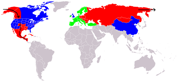
Map of fictional events in the 1984 movie Red Dawn, at the start of World War III.
- Blue = US and allies (United Kingdom "England", China "600 million screaming Chinamen", presumably Unoccupied Canada)
- Green = Neutral (Europe, "they're sitting this one out")
- Red = USSR and allies (showing USSR invasion of Alaska "stopped butt cold" at the contiguous 48 US border, Occupied Canadian Provinces of British Columbia, Western portion of Alberta and the Yukon Territory, Honduras, El Salvador, and Guatemala fall, Mexico in revolution, Texas described as being behind enemy lines, Oklahoma and most of Kansas, Louisiana, Arkansas, and Missouri probably overrun too, Colorado where the movie is set - invasion force stopped at Cheyenne, Wyoming. Blue circle shows Denver under siege.)
- Grey = Unknown
- Red squares = use of Soviet nuclear weapons - Beijing "there were", Washington, Kansas City & Omaha
At the end of the movie the US is implied on a plaque as having won the war, although how they did it is not explained.
If The US stopped them at the Mississippi River, then the color used for the US state Mississippi is incorrect. Mississippi would be part of F.A. (Free America) not occupied as the map indicates.
Licensiering

|
Tillstånd ges att kopiera, distribuera och/eller modifiera detta dokument under villkoren i GNU Free Documentation License, Version 1.2 eller senare version publicerad av Free Software Foundation, utan oföränderliga avsnitt, framsidestexter eller baksidestexter. En kopia av licensen ingår i avsnittet GNU Free Documentation License. |
| Denna fil har gjorts tillgänglig under licensen Creative Commons Erkännande-Dela Lika 3.0 Generisk | ||
| ||
| Detta licenstillägg lades till till denna fil som en del av GFDL:s licensuppdatering. |

|
Denna bild (eller alla bilder i denna artikel eller kategori) bör återskapas med hjälp av vektorgrafik som en SVG-fil. Detta har flera fördelar; se Commons:Media for cleanup för mer information. Om det redan existerar en SVG-version av denna bild, var vänlig och lägg upp den. Efter att en SVG-version lagts upp, ersätt denna mall med {{vector version available|nytt bildnamn.svg}} på denna sida.
|
Filhistorik
Klicka på ett datum/klockslag för att se filen som den såg ut då.
| Datum/Tid | Miniatyrbild | Dimensioner | Användare | Kommentar | |
|---|---|---|---|---|---|
| nuvarande | 23 december 2008 kl. 22.09 | | 1 400 × 628 (49 kbyte) | Shibo77 | {{Information |Description=.. |Source=Roke |Date=.. |Author=Roke |Permission=.. |other_versions=.. }} <!--{{ImageUpload|basic}}--> |
| 18 juni 2008 kl. 14.36 |  | 1 400 × 628 (49 kbyte) | Peephole | {{Information |Description= |Source= |Date= |Author= |Permission= |other_versions= }} | |
| 5 oktober 2007 kl. 03.14 |  | 1 400 × 628 (49 kbyte) | Hoshie | added Cabinda (between Angola and Zaire), fixed YAR/PDRY boundary. | |
| 10 september 2007 kl. 21.17 |  | 1 400 × 628 (49 kbyte) | Bart133 | == Summary == Map of fictional events in 1984 movie Red Dawn, at the start of World War III *Blue = US and allies (United Kingdom, China "600 million screaming Chinamen", presumably Unoccupied Canada) *Green = Neutral (Europe, "they're sitting this one o | |
| 13 april 2006 kl. 02.54 |  | 1 400 × 628 (49 kbyte) | Roke~commonswiki | Map of fictional events in 1984 movie Red Dawn, at the start of World War III Blue = US and allies (England, China "600 million screaming Chinamen", presumably Canada) Green = Neutral (Europe, "theyre sitting this one out") Red = USSR and allies (showing |
Filanvändning
Följande sida använder den här filen:
Global filanvändning
Följande andra wikier använder denna fil:
- Användande på ar.wikipedia.org
- Användande på ca.wikipedia.org
- Användande på cy.wikipedia.org
- Användande på de.wikipedia.org
- Användande på en.wikipedia.org
- Användande på eo.wikipedia.org
- Användande på es.wikipedia.org
- Användande på eu.wikipedia.org
- Användande på fi.wikipedia.org
- Användande på fr.wikipedia.org
- Användande på id.wikipedia.org
- Användande på it.wikipedia.org
- Användande på ja.wikipedia.org
- Användande på ko.wikipedia.org
- Användande på ms.wikipedia.org
- Användande på nds.wikipedia.org
- Användande på nl.wikipedia.org
- Användande på no.wikipedia.org
- Användande på pl.wikipedia.org
- Användande på pt.wikipedia.org
- Användande på ru.wikipedia.org
- Användande på simple.wikipedia.org
- Användande på uk.wikipedia.org
- Användande på zh.wikipedia.org