
Fil:Reliefkarte Schwyz.png
Storlek på förhandsvisningen: 728 × 600 pixlar. Andra upplösningar: 291 × 240 pixlar | 583 × 480 pixlar | 932 × 768 pixlar | 1 243 × 1 024 pixlar | 2 157 × 1 777 pixlar.
Originalfil (2 157 × 1 777 pixlar, filstorlek: 3,58 Mbyte, MIME-typ: image/png)
| Denna fil tillhandahålls av Wikimedia Commons. Informationen nedan är kopierad från dess filbeskrivningssida. |
| Beskrivning |
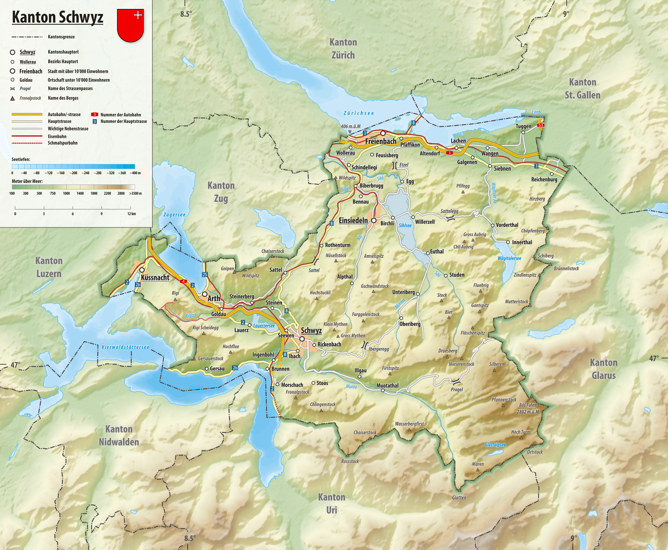
Deutsch: Reliefkarte des Kantons Schwyz
Topographischer Hintergrund: NASA Shuttle Radar Topography Mission (public domain). SRTM3 v.2. |
||||||||
| Datum | |||||||||
| Källa | Eget arbete | ||||||||
| Skapare | Tschubby | ||||||||
| Tillstånd (Återanvändning av denna fil) |
Jag, upphovsrättsinnehavaren av detta verk, publicerar härmed det under följande licenser:
Denna fil har gjorts tillgänglig under licenserna Creative Commons Erkännande-Dela Lika 2.5 Generisk, 2.0 Generisk och 1.0 Generisk.
Du får själv välja den licens du vill använda. |

Filhistorik
Klicka på ett datum/klockslag för att se filen som den såg ut då.
| Datum/Tid | Miniatyrbild | Dimensioner | Användare | Kommentar | |
|---|---|---|---|---|---|
| nuvarande | 30 januari 2019 kl. 16.32 | | 2 157 × 1 777 (3,58 Mbyte) | Tschubby | {{Information |description= |date= |source= |author= |permission= |other versions= }} |
| 8 maj 2016 kl. 07.43 |  | 1 798 × 1 482 (1,98 Mbyte) | Tschubby | {{Information |Description= |Source= |Date= |Author= |Permission= |other_versions= }} | |
| 16 augusti 2013 kl. 14.45 |  | 1 802 × 1 485 (2,84 Mbyte) | Tschubby | {{Information |Description= |Source= |Date= |Author= |Permission= |other_versions= }} | |
| 23 juli 2013 kl. 17.54 |  | 1 801 × 1 483 (2,98 Mbyte) | Tschubby | {{Information |Description= |Source= |Date= |Author= |Permission= |other_versions= }} | |
| 23 juli 2013 kl. 17.52 |  | 1 801 × 1 483 (2,99 Mbyte) | Tschubby | {{Information |Description= |Source= |Date= |Author= |Permission= |other_versions= }} | |
| 23 juli 2013 kl. 17.47 |  | 1 801 × 1 483 (2,99 Mbyte) | Tschubby | {{Information |Description= |Source= |Date= |Author= |Permission= |other_versions= }} | |
| 23 juli 2013 kl. 17.23 |  | 1 801 × 1 483 (2,99 Mbyte) | Tschubby | {{Information |Description= {{de| Reliefkarte des Kantons Schwyz}} Topographischer Hintergrund: [http://www2.jpl.nasa.gov/srtm NASA Shuttle Radar Topography Mission] (public domain). SRTM3 v.2. |Source={{own}} |Date= 2013-07-23 |Author= [[:de:User:Tsch... |
Filanvändning
Följande sida använder den här filen:
Global filanvändning
Följande andra wikier använder denna fil:
- Användande på als.wikipedia.org
- Användande på de.wikipedia.org
- Användande på zh.wikipedia.org