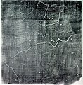
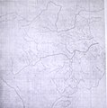
Fil:Song Dynasty Map.JPG

Sidans innehåll stöds inte på andra språk.
Från Wikipedia

Originalfil(756 × 768 pixlar, filstorlek: 436 kbyte, MIME-typ: image/jpeg)

Info

Beskrivning

The Chinese Yu Ji Tu (Map of the Tracks of Yu the Great), a map carved into stone in the year 1137 during the Song Dynasty, located in the Stele Forest of modern-day Xian, China. Yu the Great refers to the Chinese deity described in the Chinese geographical work of the Yu Gong, a chapter of the Classic of History. Needham and Chavannes assert that the original map must have predated the 12th century.

The graduated scale of this gridded map is at 100 li (Chinese mile) squared for every representative square in the grid. The overall size of the map is 3 ft squared. The coastal outline is relatively firm and the precision of the network of river systems is incredibly accurate. The name of the geographers and cartographers who initially created the map are unknown. In the year 1142 a copy of the map was preserved at Zhenjiang in Jiangsu province by a certain Yu Chi, who was then a Prefectural Director of Studies. There is also mention of an earlier copy of about 1100 AD which itself was based on the Chang'an version. Needham asserts that the map was used primarily to instruct students while referring to sites described in the ancient Yu Gong chapter of the Classic of History.
Datum printing of a rubbing of a c. 1136 engraving of a c. 1100 map
Källa Joseph Needham's Science and Technology in China, Vol. 3: Mathematics and the Sciences of the Heavens and the Earth, Plate LXXXI and text description pp. 547–549, hardback edition
Skapare Unknown, photo by PericlesofAthens


Public domain

Detta verk är också upphovsrättsfritt i länder och områden där upphovsrätten förfaller 70 år eller färre efter upphovsmannens död.


Du måste även inkludera en tagg för allmän egendom i USA för att indikera varför detta verk är allmän egendom i USA. Observera att i en del länder förfaller upphovsrätten senare än efter 70 år: Mexiko har 100 år, Jamaica har 95 år, Colombia har 80 år, samt Guatemala och Samoa har 75 år. Denna bild kanske inte är allmän egendom i dessa länder, som också inte uppfyller regeln om kortare sikt.

Public domain Jag, upphovsrättsinnehavaren till detta verk, släpper detta verk i public domain. Detta gäller globalt.
I vissa länder kan detta inte vara juridiskt möjligt; i så fall:
Jag ger härmed envar rätten att använda detta verk för alla ändamål, utan några villkor, förutom villkor som lagen ställer.

Bildtexter

Ingen bildtext har definierats

Objekt som porträtteras i den här filen

motiv

Filhistorik

Klicka på ett datum/klockslag för att se filen som den såg ut då.

Datum/TidMiniatyrbildDimensionerAnvändareKommentar
nuvarande3 augusti 2011 kl. 09.25Miniatyrbild för versionen från den 3 augusti 2011 kl. 09.25756 × 768 (436 kbyte)Dragonet~commonswikibetter quality
3 november 2007 kl. 12.32Miniatyrbild för versionen från den 3 november 2007 kl. 12.32834 × 843 (89 kbyte)PericlesofAthens{{Information |Description=The Chinese ''Yu Ji Tu'' (Map of the Tracks of Yu the Great), a map carved into stone in the year 1137 during the Song Dynasty, located in the Stele Forest of modern-day Xian, China. Yu the Great refers to the Chinese deity desc

Följande sida använder den här filen:

Global filanvändning

Följande andra wikier använder denna fil:

Metadata