
Fil:Syria pop.jpg

Storlek på förhandsvisningen: 408 × 599 pixlar. Andra upplösningar: 163 × 240 pixlar | 327 × 480 pixlar | 682 × 1 002 pixlar.
Originalfil (682 × 1 002 pixlar, filstorlek: 86 kbyte, MIME-typ: image/jpeg)
| Denna fil tillhandahålls av Wikimedia Commons. Informationen nedan är kopierad från dess filbeskrivningssida. |
Sammanfattning
| Beskrivning |
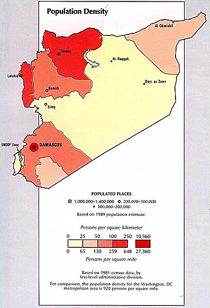
English: Syria - Population Density from the CIA Atlas of the Middle East 1993 (86K) |
| Källa | Perry-Castañeda Library Map Collection at The University of Texas at Austin [1] |
| Skapare | |
| Tillstånd (Återanvändning av denna fil) |
Above a list of maps available for download, the web site has the text: The following maps were produced by the U.S. Central Intelligence Agency, unless otherwise indicated.. There is no indication that this map was not produced by the CIA. |
| Andra versioner |
 |


Licensiering
| This image is a work of a Central Intelligence Agency employee, taken or made as part of that person's official duties. As a Work of the United States Government, this image or media is in the public domain in the United States.
|

|
Filhistorik
Klicka på ett datum/klockslag för att se filen som den såg ut då.
| Datum/Tid | Miniatyrbild | Dimensioner | Användare | Kommentar | |
|---|---|---|---|---|---|
| nuvarande | 19 februari 2007 kl. 11.10 | | 682 × 1 002 (86 kbyte) | Khoikhoi~commonswiki | ==Summary== '''Syria - Population Density from the CIA Atlas of the Middle East 1993 (86K)''' *Source: Perry-Castañeda Library Map Collection at The University of Texas at Austin [http://www.lib.utexas.edu/maps/middle_east.html] *License: Above a list o |
Filanvändning
Följande sida använder den här filen:
Global filanvändning
Följande andra wikier använder denna fil:
- Användande på ba.wikipedia.org
- Användande på en.wikipedia.org
- Användande på es.wikipedia.org
- Användande på fa.wikipedia.org
- Användande på hr.wikipedia.org
- Användande på ka.wikipedia.org
- Användande på kk.wikipedia.org
- Användande på lt.wikipedia.org
- Användande på ru.wikipedia.org
- Användande på ta.wikipedia.org
- Användande på tr.wikipedia.org
- Användande på vi.wikipedia.org