
Flygplatser i Schweiz

Flygplatser i Schweiz är cirka 70 stycken till antalet varav de flesta är civila flygplatser. Zürichs internationella flygplats är den största och mest trafikerade, följd av Genèves internationella flygplats utanför Genève. Efter det kommer Basel-Mulhouse-Freiburg flygplats, som dock ligger i Frankrike, men delägs av Basels stad och där Basel är närmaste och största närliggande stad.
Framtida flygplatser[redigera | redigera wikitext]
- Byggandet av en flygplats pågår i Schribersmatt, utanför Giswil och Lungern.[1][2] Flygplatsen kommer att ha en landningsbana på 1 070 m.[källa behövs]
- Renoveringen av flygplatsen i Yverdon-les-Bains pågår fram till november 2009. Sommaren 2009 stod en nybyggd asfaltsbana klar. Gräsbanan som existerat sedan lång tid tillbaka har renoverats.
Lista över flygplatser i Schweiz[redigera | redigera wikitext]
Följande är en lista över olika flygplatser i Schweiz år 2009.[3] Längderna på landningsbanorna är i många fall ungefärliga.
Förklaring[redigera | redigera wikitext]
- ICAO, International Civil Aviation Organization, är en 4-bokstävers flygplatskod, som används för att lokalisera flygplatser.[3]
- IATA, International Air Transport Association, är en 3-letter som identifierar den relevanta flygplatsen.[3]
- Användning
Flygplatser delas ofta in i tre olika kategorier: civila flygplatser, öppna för privatplan och passageraflygplan. Militära flygplatser och privata flygplatser, ej öppna för allmänheten. Flygplatser kan platsa i både den militära och civila kategorin har kategoriserats som civila flygplatser i ovanstående lista.[3]
- Fetmarkering
Flygplatser som är något större, betydligare och mer trafikerade än andra (500 000 besökare per år är en ungefärlig gräns i detta fall) har markerats med fetstil.
Lista[redigera | redigera wikitext]
Galleri[redigera | redigera wikitext]
-
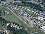
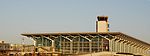 Basels flygplats.
 -
 Berns flygplats.
 -
 Samedan/Engadin flygplats.
 -
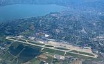 Genevé flygplats.
 -
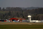
 Tornet vid Grenchen flygplats.
 -
 Intelaken flygplats, utsikt över Interlaken, Bönigen och Ringgenberg.
 -
 Lugano flygplats.
 -
 Lausanne flygplats.
 -

-
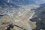
 Sions flygplats.
 -
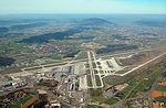 Zürich/Kloten flygplats.


Referenser[redigera | redigera wikitext]
- ^ ”avianna.ch/galerie”. http://www.avianna.ch/galerie/main.php/f/Obergoms/013.jpg.html. Läst 29 november 2024.[död länk]
- ^ ”Karta, Giswil”. http://www.snow-forecast.com/snowobjects/Giswil-Morlialp.jpg. Läst 26 februari.
- ^ [a b c d] ”Airports in Switzerland”. Arkiverad från originalet den 15 mars 2010. https://web.archive.org/web/20100315122334/http://www.aircraft-charter-world.com/airports/europe/switzerland.htm. Läst 29 november 2024.