
Fil:113th US Congress House districts color.svg

Storleken för denna PNG-förhandsvisning av denna SVG-fil: 800 × 464 pixlar. Andra upplösningar: 320 × 186 pixlar | 640 × 372 pixlar | 1 024 × 594 pixlar | 1 280 × 743 pixlar | 2 560 × 1 486 pixlar | 1 242 × 721 pixlar.
Originalfil (SVG-fil, standardstorlek: 1 242 × 721 pixlar, filstorlek: 3,9 Mbyte)
| Denna fil tillhandahålls av Wikimedia Commons. Informationen nedan är kopierad från dess filbeskrivningssida. |
Sammanfattning
| Beskrivning |
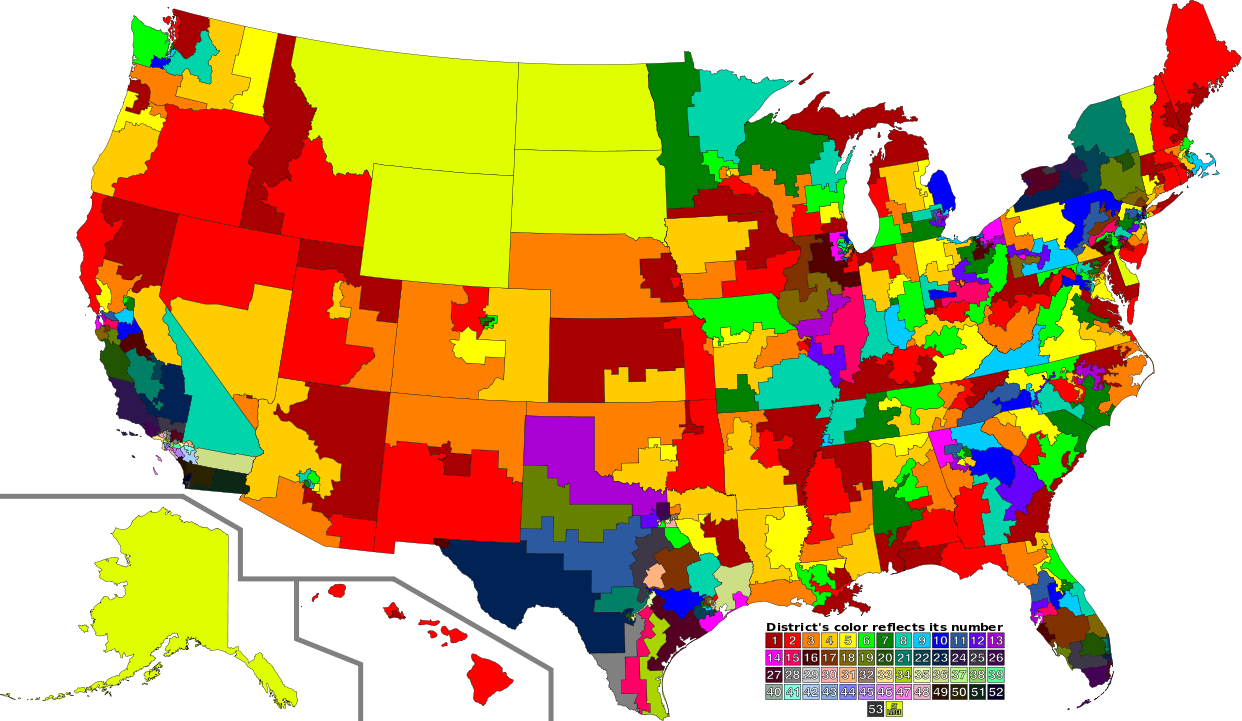
English: A map of all of the U.S. congressional districts (as of the 113th Congress). To find the district's number, look at the district, compare with the color code at the bottom to get number. The colors do not have any intrinsic meaning other than to provide visual distinction. |
| Datum | |
| Källa |
Denna fil bygger på: |
| Skapare |
|
| SVG utveckling | Den här stor Det karta skapades med Inkscape. |
Licensiering
Denna fil har gjorts tillgänglig under licensen Creative Commons Erkännande 3.0 Generisk
- Du är fri:
- att dela – att kopiera, distribuera och sända verket
- att remixa – att skapa bearbetningar
- På följande villkor:
- erkännande – Du måste ge lämpligt erkännande, ange en länk till licensen och indikera om ändringar har gjorts. Du får göra det på ett lämpligt sätt, men inte på ett sätt som antyder att licensgivaren stödjer dig eller din användning.
Ursprunglig uppladdningslogg
This image is a derivative work of the following images:
- File:US Congressional Districts color.svg licensed with PD-self
- 2009-09-14T22:28:34Z Mr. Matté 2583x1557 (1299871 Bytes) Fix western CA districts
- 2009-07-17T15:45:17Z Mr. Matté 2583x1557 (1280927 Bytes) Fix NY 26/27, make one path --> text
- 2008-08-21T02:52:58Z Mr. Matté 2583x1557 (1306679 Bytes) Fix Hawaii
- 2008-04-16T02:38:02Z Mr. Matté 2583x1557 (1366638 Bytes) Higher-quality, smaller version of the colored congressional map by district number
- 2008-02-06T23:06:44Z Mr. Matté 9111x5493 (1961159 Bytes) {{Information |Description=A map of all of the [[:en:List of United States congressional districts|U.S. congressional districts]] (as of the [[:en:110th United States Congress|110th Congress]]). To find the district's number
- File:113th U.S. Congress House districts blank.svg licensed with Cc-zero
Uploaded with derivativeFX
Filhistorik
Klicka på ett datum/klockslag för att se filen som den såg ut då.
| Datum/Tid | Miniatyrbild | Dimensioner | Användare | Kommentar | |
|---|---|---|---|---|---|
| nuvarande | 31 augusti 2012 kl. 05.02 | | 1 242 × 721 (3,9 Mbyte) | Magog the Ogre | GA 02/08 accidentally transposed |
| 31 augusti 2012 kl. 03.47 |  | 1 242 × 721 (3,9 Mbyte) | Magog the Ogre | {{Information |Description={{en|1=A map of all of the U.S. congressional districts (as of the 113th Congress). To find the district's number, look at the distric... |
Filanvändning
Följande sida använder den här filen:
Global filanvändning
Följande andra wikier använder denna fil:
- Användande på de.wikipedia.org
- Användande på fa.wikipedia.org
- Användande på fr.wikipedia.org
- Användande på nl.wikipedia.org