
Fil:Carnegie Free Library, 300 East South Street, Union (Union County, South Carolina).jpg

Storlek på förhandsvisningen: 800 × 556 pixlar. Andra upplösningar: 320 × 222 pixlar | 640 × 444 pixlar | 1 024 × 711 pixlar | 1 280 × 889 pixlar | 2 560 × 1 778 pixlar | 4 611 × 3 202 pixlar.
Originalfil (4 611 × 3 202 pixlar, filstorlek: 1,48 Mbyte, MIME-typ: image/jpeg)
| Denna fil tillhandahålls av Wikimedia Commons. Informationen nedan är kopierad från dess filbeskrivningssida. |
|
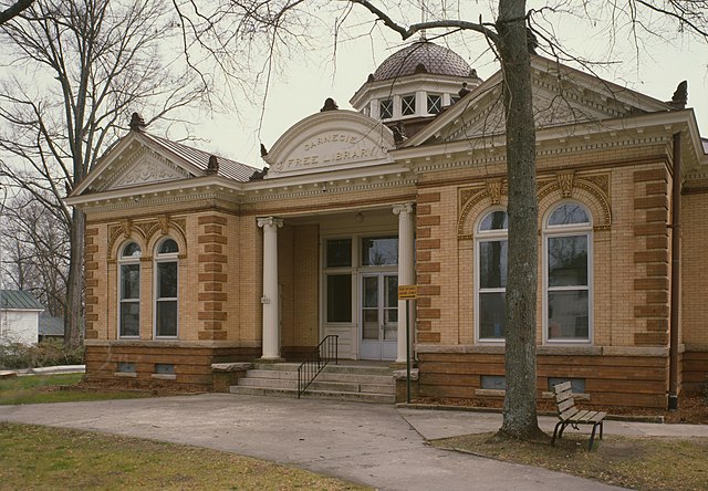
This is an image of a place or building that is listed on the National Register of Historic Places in the United States of America. Its reference number is 83002211. |
| Beskrivning |
English: Front of the Union Carnegie Free Library, located at 300 E. South Street in Union, South Carolina, United States. Built in 1905, it is part of the South Street-South Church Street Historic District, a historic district that is listed on the National Register of Historic Places. |
|||||||||||||||||||||||||
| Datum | ||||||||||||||||||||||||||
| Källa |
Library of Congress, Prints and Photograph Division
|
|||||||||||||||||||||||||
| Skapare |
|
|||||||||||||||||||||||||
| Tillstånd (Återanvändning av denna fil) |
|
|||||||||||||||||||||||||


.jpg)
| Kameraposition | | Se denna och andra närliggande bilder på: OpenStreetMap |
|---|
.jpg¶ms=034.713333_N_-081.620667_E_globe:Earth_type:camera__&language=sv)
Filhistorik
Klicka på ett datum/klockslag för att se filen som den såg ut då.
| Datum/Tid | Miniatyrbild | Dimensioner | Användare | Kommentar | |
|---|---|---|---|---|---|
| nuvarande | 11 februari 2010 kl. 02.09 | | 4 611 × 3 202 (1,48 Mbyte) | Nyttend | Much higher resolution |
| 21 mars 2009 kl. 13.40 |  | 585 × 409 (96 kbyte) | KudzuVine | {{Information |Description={{en|1=Carnegie Free Library, 300 East South Street, Union (Union County, South Carolina) {{PD-USGov-Interior-HABS}} {{HABS| SC,44-UNI,1-13}}}} |Source=http://memory.loc.gov/cgi-bin/displayPhoto.pl?path=/pnp/habshaer/sc/sc0700/s |
Filanvändning
Följande sida använder den här filen:
Global filanvändning
Följande andra wikier använder denna fil:
- Användande på ar.wikipedia.org
- Användande på ceb.wikipedia.org
- Användande på ce.wikipedia.org
- Användande på cy.wikipedia.org
- Användande på en.wikipedia.org
- Användande på es.wikipedia.org
- Användande på fr.wikipedia.org
- Användande på ga.wikipedia.org
- Användande på hu.wikipedia.org
- Användande på hy.wikipedia.org
- Användande på it.wikipedia.org
- Användande på ko.wikipedia.org
- Användande på no.wikipedia.org
- Användande på pl.wikipedia.org
- Användande på pt.wikipedia.org
- Användande på ro.wikipedia.org
- Användande på ru.wikipedia.org
- Användande på simple.wikipedia.org
- Användande på sr.wikipedia.org
- Användande på tr.wikipedia.org
- Användande på tt.wikipedia.org
- Användande på ur.wikipedia.org
- Användande på www.wikidata.org
.jpg)