
Fil:Cordón del Azufre.jpg
Det finns ingen version med högre upplösning.
Cordón_del_Azufre.jpg (640 × 422 pixlar, filstorlek: 74 kbyte, MIME-typ: image/jpeg)
| Denna fil tillhandahålls av Wikimedia Commons. Informationen nedan är kopierad från dess filbeskrivningssida. |
Sammanfattning
| Beskrivning |
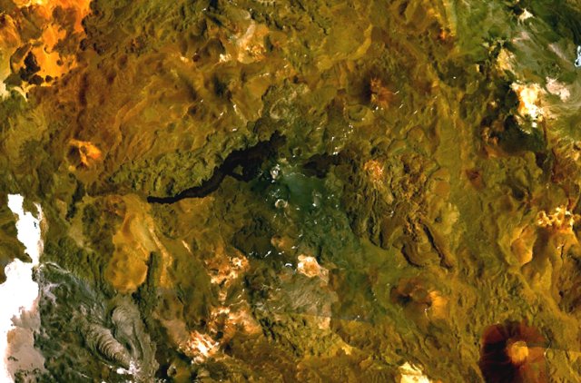
English: The volcanic complex in the center of this NASA Landsat composite image is Cordón del Azufre, a small volcanic center straddling the Chile-Argentina border. A dacitic lava-dome complex lies at the eastern side of the complex, in Argentina. The prominent dark-colored lava flow from Volcán la Moyra, the youngest feature of the volcanic field, descended 6 km into Chile and 3 km into Argentina. Lava flows from Bayo volcano to the SW are visible at the lower left. |
| Datum | Okänt datum |
| Källa | http://www.volcano.si.edu/world/volcano.cfm?vnum=1505-121&volpage=photos&photo=115040 |
| Skapare | NASA Landsat7 image (worldwind.arc.nasa.gov) |
Licensiering
| This image is in the public domain because it is a screenshot from NASA’s globe software World Wind using a public domain layer, such as Blue Marble, MODIS, Landsat, SRTM, USGS or GLOBE.
|
 |
Filhistorik
Klicka på ett datum/klockslag för att se filen som den såg ut då.
| Datum/Tid | Miniatyrbild | Dimensioner | Användare | Kommentar | |
|---|---|---|---|---|---|
| nuvarande | 16 oktober 2010 kl. 21.02 | | 640 × 422 (74 kbyte) | Michael Metzger | {{Information |Description={{en|1=The volcanic complex in the center of this NASA Landsat composite image is Cordón del Azufre, a small volcanic center straddling the Chile-Argentina border. A dacitic lava-dome complex lies at the eastern side of the com |
Filanvändning
Följande sida använder den här filen:
Global filanvändning
Följande andra wikier använder denna fil:
- Användande på arz.wikipedia.org
- Användande på ceb.wikipedia.org
- Användande på de.wikipedia.org
- Användande på en.wikipedia.org
- Användande på es.wikipedia.org
- Användande på eu.wikipedia.org
- Användande på fa.wikipedia.org
- Användande på fr.wikipedia.org
- Användande på hu.wikipedia.org
- Användande på lld.wikipedia.org
- Användande på ms.wikipedia.org
- Användande på pl.wikipedia.org
- Användande på sk.wikipedia.org
- Användande på www.wikidata.org
- Användande på zh.wikipedia.org