
Fil:Lake Whitney & Whitney Dam.jpg

Storlek på förhandsvisningen: 800 × 533 pixlar. Andra upplösningar: 320 × 213 pixlar | 640 × 427 pixlar | 1 024 × 683 pixlar | 1 500 × 1 000 pixlar.
Originalfil (1 500 × 1 000 pixlar, filstorlek: 234 kbyte, MIME-typ: image/jpeg)
| Denna fil tillhandahålls av Wikimedia Commons. Informationen nedan är kopierad från dess filbeskrivningssida. |
| Beskrivning |
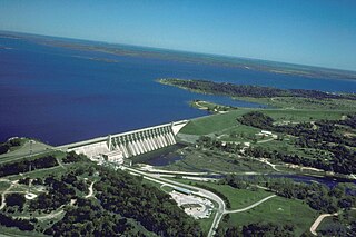
English: Aerial view of Whitney Lake and Dam on the Brazos River in Bosque and Hill Counties, Texas, USA. The river and lake form part of the border between the two counties. The U.S. Army Corps of Engineers constructed the dam in 1951 for flood control and water supply. View is to the north.
Coordinates: 31°51′59.45″N 97°22′15.64″W / 31.8665139°N 97.3710111°W |
|||
| Plats | Bosque and Hill Counties, Texas, USA | |||
| Datum | not specified or unknown | |||
| Källa |
U.S. Army Corps of Engineers Digital Visual Library Image page Image description page Digital Visual Library home page |
|||
| Skapare | U.S. Army Corps of Engineers, photographer not specified or unknown | |||
| Tillstånd (Återanvändning av denna fil) |
|
Filhistorik
Klicka på ett datum/klockslag för att se filen som den såg ut då.
| Datum/Tid | Miniatyrbild | Dimensioner | Användare | Kommentar | |
|---|---|---|---|---|---|
| nuvarande | 19 maj 2007 kl. 03.39 | | 1 500 × 1 000 (234 kbyte) | DanMS | {{Information | Description = {{en|Aerial view of Whitney Lake and Dam on the Brazos River in Bosque and Hill Counties, Texas, USA. The river and lake form part of the border between the two counties. The U.S. Army Corps of Engineers constructed the da |
Filanvändning
Följande sida använder den här filen:
Global filanvändning
Följande andra wikier använder denna fil:
- Användande på bo.wikipedia.org
- Användande på ceb.wikipedia.org
- Användande på da.wikipedia.org
- Användande på de.wikipedia.org
- Användande på en.wikipedia.org
- Användande på es.wikipedia.org
- Användande på fa.wikipedia.org
- Användande på fr.wikipedia.org
- Användande på ja.wikipedia.org
- Användande på no.wikipedia.org
- Användande på www.wikidata.org