
Fil:Map of Constantinople (1422) by Florentine cartographer Cristoforo Buondelmonte.jpg
Storlek på förhandsvisningen: 476 × 600 pixlar. Andra upplösningar: 190 × 240 pixlar | 592 × 746 pixlar.
Originalfil (592 × 746 pixlar, filstorlek: 838 kbyte, MIME-typ: image/jpeg)
| Denna fil tillhandahålls av Wikimedia Commons. Informationen nedan är kopierad från dess filbeskrivningssida. |
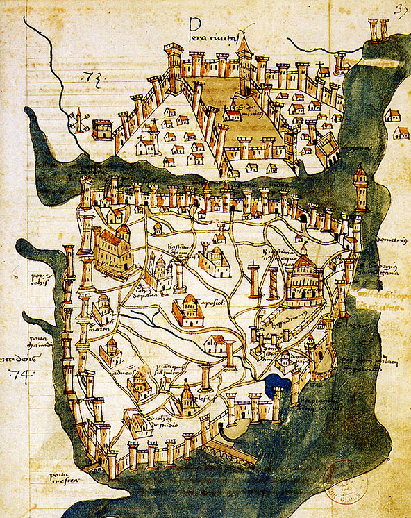
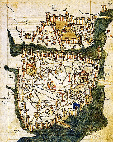
| Beskrivning | Map of Constantinople (a small part of modern Istanbul), called "Historic Peninsula", Tarihi Yarımada en Turkish) designed in 1422 by Florentine cartographer Cristoforo Buondelmonti (Description des îles de l'archipel, Bibliothèque nationale, Paris) is the oldest surviving map of the city, and the only surviving map which predates the Turkish conquest of Constantinople in 1453. | ||||
| Datum | |||||
| Källa | Liber insularum Archipelagi (1824), version available at the Bibliothèque nationale de France, Paris | ||||
| Skapare | Cristoforo Buondelmonti | ||||
| Tillstånd (Återanvändning av denna fil) |
|
||||
| Andra versioner |
|
||||

_by_Florentine_cartographer_Cristoforo_Buondelmonte.jpg)
Filhistorik
Klicka på ett datum/klockslag för att se filen som den såg ut då.
| Datum/Tid | Miniatyrbild | Dimensioner | Användare | Kommentar | |
|---|---|---|---|---|---|
| nuvarande | 25 juni 2007 kl. 12.24 | | 592 × 746 (838 kbyte) | M.K. | {{Information |Description=Map of Constantinople (1422) by Florentine cartographer Cristoforo Buondelmonte (''Description des îles de l'archipel'', Bibliothèque nationale, Paris) is the oldest surviving map of the city, and the only surviving ma |
Filanvändning
Följande sida använder den här filen:
Global filanvändning
Följande andra wikier använder denna fil:
- Användande på ar.wikipedia.org
- Användande på az.wikipedia.org
- Användande på ba.wikipedia.org
- Användande på bg.wikipedia.org
- Användande på ca.wikipedia.org
- Användande på ce.wikipedia.org
- Användande på cs.wikipedia.org
- Användande på de.wikipedia.org
- Användande på el.wikipedia.org
- Användande på en.wikipedia.org
- Bosporus
- Constantinople
- Constantine XI Palaiologos
- John VII Palaiologos
- Walls of Constantinople
- Beyoğlu
- Maiden's Tower
- Siege of Constantinople (1422)
- Siege of Constantinople (1411)
- Template:Did you know nominations/Kontoskalion
- Piyalepaşa, Beyoğlu
- Wikipedia:Main Page history/2019 February 23
- Siege of Constantinople (1394–1402)
- Användande på es.wikipedia.org
- Användande på et.wikipedia.org
- Användande på eu.wikipedia.org
- Användande på fa.wikipedia.org
- Användande på frp.wikipedia.org
- Användande på fr.wikipedia.org
Visa mer globalt användande av denna fil.
_by_Florentine_cartographer_Cristoforo_Buondelmonte.jpg)
_by_Florentine_cartographer_Cristoforo_Buondelmonte.jpg)