
Fil:Maryland Campaign.png
Storlek på förhandsvisningen: 531 × 600 pixlar. Andra upplösningar: 212 × 240 pixlar | 425 × 480 pixlar | 680 × 768 pixlar | 906 × 1 024 pixlar | 1 601 × 1 809 pixlar.
Originalfil (1 601 × 1 809 pixlar, filstorlek: 576 kbyte, MIME-typ: image/png)
| Denna fil tillhandahålls av Wikimedia Commons. Informationen nedan är kopierad från dess filbeskrivningssida. |
Sammanfattning
| Beskrivning |
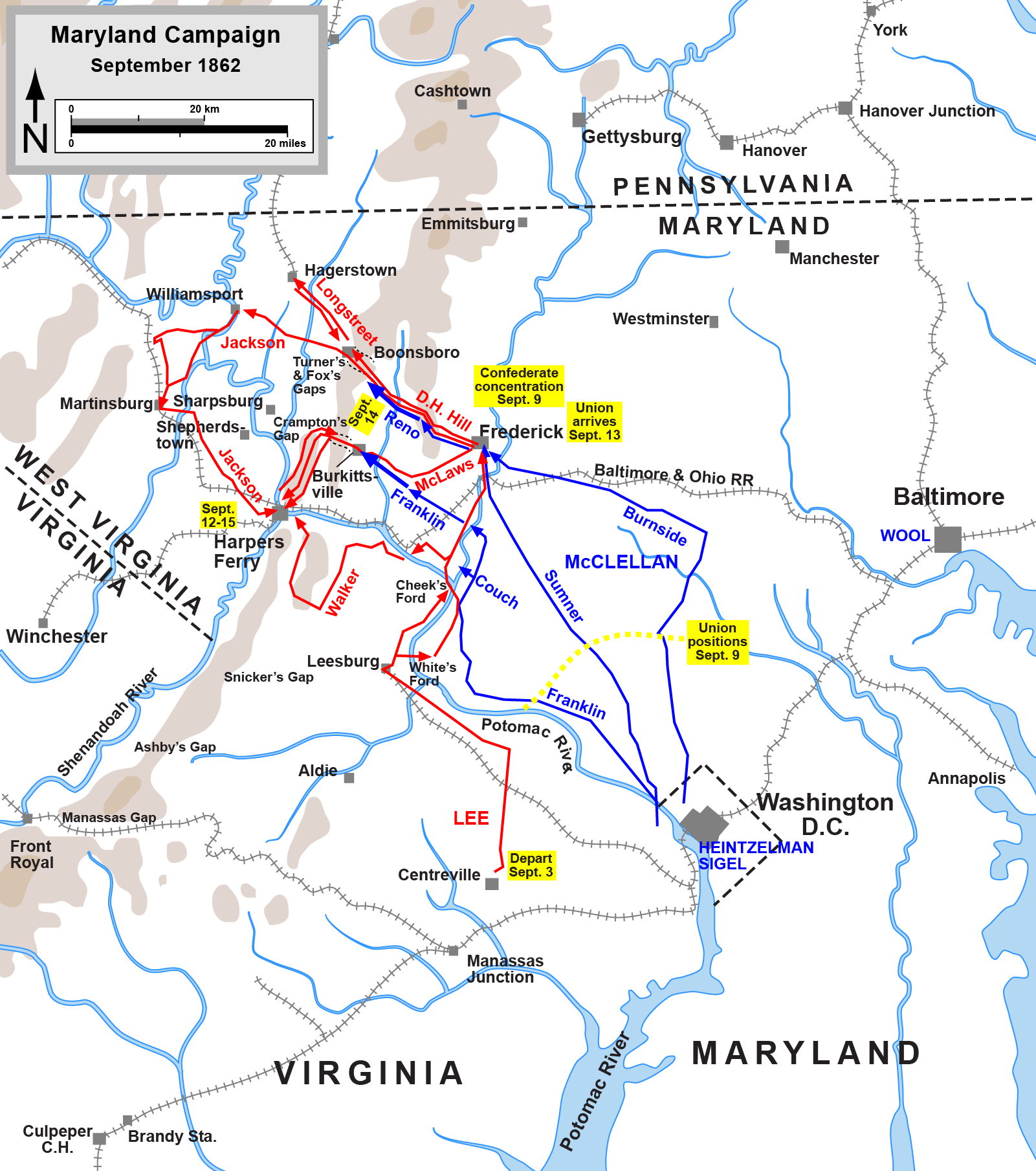
English: Map of the Maryland Campaign of the American Civil War, actions Sept. 3-15. Drawn by Hal Jespersen in Adobe Illustrator CS5. Graphic source file is available at http://www.posix.com/CWmaps/ |
| Datum | (first version); 6 mars 2011 (last version) |
| Källa | http://www.posix.com/CWmaps/Maryland_Campaign.png |
| Skapare | Hal Jespersen at en.wikipedia |
| PNG utveckling | Den här Det karta skapades med Adobe Illustrator |
Licensiering
| Detta verk har gjorts tillgänglig som public domain av dess skapare, Hal Jespersen. Detta gäller globalt. I vissa länder kan detta inte vara juridiskt möjligt; i så fall: Hal Jespersen ger envar rätten att använda detta verk för alla ändamål, utan några villkor, förutom villkor som lagen ställer.
|

|
Det finns en vektorversion av denna rasterbild (SVG).
När vektorbilden är lämpligare ska den användas istället för rasterbilden. File:Maryland Campaign.png → File:Maryland Campaign a.svg
För mer information om vektorgrafik, se artikeln Commons transition to SVG (på engelska). |
 |
Ursprunglig uppladdningslogg
(All user names refer to en.wikipedia)
- 2006-06-17 16:04 Hlj 1502×1700×8 (540349 bytes) Map of the [[Maryland Campaign]] of the [[American Civil War]], actions Sept. 3-15. Drawn by Hal Jespersen in Macromedia Freehand. Graphic source file is available at http://www.posix.com/CWmaps/
Filhistorik
Klicka på ett datum/klockslag för att se filen som den såg ut då.
| Datum/Tid | Miniatyrbild | Dimensioner | Användare | Kommentar | |
|---|---|---|---|---|---|
| nuvarande | 30 mars 2011 kl. 00.46 | | 1 601 × 1 809 (576 kbyte) | Hlj | Update to graphical format of rivers and roads. |
| 7 mars 2011 kl. 01.07 |  | 1 601 × 1 809 (450 kbyte) | Innotata | New version from enwiki, uploaded by original uploader. Upload summaries: "Fixed DC boundary. Adobe Illustrator source file at http://www.posix.com/CWmaps/"; "minor graphical changes to conform to style used by most ACW maps; added legend and scale." | |
| 26 april 2007 kl. 04.09 |  | 1 502 × 1 700 (528 kbyte) | Qbek | {{Information |Description=Map of the en:Maryland Campaign of the en:American Civil War, actions Sept. 3-15. Drawn by Hal Jespersen in Macromedia Freehand. Graphic source file is available at http://www.posix.com/CWmaps/ |Source=Originally from |
Filanvändning
Inga sidor använder den här filen.
Global filanvändning
Följande andra wikier använder denna fil:
- Användande på azb.wikipedia.org
- Användande på cs.wikipedia.org
- Användande på da.wikipedia.org
- Användande på de.wikipedia.org
- Användande på es.wikipedia.org
- Användande på fa.wikipedia.org
- Användande på fr.wikipedia.org
- Användande på hu.wikipedia.org
- Användande på it.wikipedia.org
- Användande på ja.wikipedia.org
- Användande på ko.wikipedia.org
- Användande på la.wikipedia.org
- Användande på ms.wikipedia.org
- Användande på nl.wikipedia.org
- Användande på no.wikipedia.org
- Användande på pl.wikipedia.org
- Användande på pt.wikipedia.org
- Användande på ro.wikipedia.org
- Användande på sr.wikipedia.org
- Användande på vi.wikipedia.org
- Användande på zh.wikipedia.org