
Fil:Mid-atlantic ridge map.png
Det finns ingen version med högre upplösning.
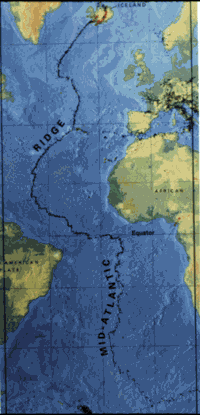
Mid-atlantic_ridge_map.png (200 × 415 pixlar, filstorlek: 21 kbyte, MIME-typ: image/png)
| Denna fil tillhandahålls av Wikimedia Commons. Informationen nedan är kopierad från dess filbeskrivningssida. |
| Beskrivning | small image showing the location of the Mid-Atlantic ridge |
| Källa | [1] |
| Skapare | originally uploaded on the English wikipedia: 14:51, 21 October 2003 . . JamesDay (Talk / contribs) . . 200×415 (21,177 bytes) (mid-Atlantic ridge map) |
| Tillstånd (Återanvändning av denna fil) |
Copyright: public domain. US Geological Survey image. Copyright statement: [2] "Information presented on this website is considered public information and may be distributed or copied. Use of appropriate byline/photo/image credit is requested." |
This image is in the public domain in the United States because it only contains materials that originally came from the United States Geological Survey, an agency of the United States Department of the Interior. For more information, see the official USGS copyright policy.
|
Filhistorik
Klicka på ett datum/klockslag för att se filen som den såg ut då.
| Datum/Tid | Miniatyrbild | Dimensioner | Användare | Kommentar | |
|---|---|---|---|---|---|
| nuvarande | 1 februari 2007 kl. 13.02 | | 200 × 415 (21 kbyte) | Woudloper | {{Information |Description=small image showing the location of the Mid-Atlantic ridge |Source=[http://pubs.usgs.gov/publications/text/ridge.html] |Date= |Author=originally uploaded on the English wikipedia: 14:51, 21 October 2003 . . JamesDay (Talk | cont |
Filanvändning
Inga sidor använder den här filen.
Global filanvändning
Följande andra wikier använder denna fil:
- Användande på ar.wikipedia.org
- Användande på ast.wikipedia.org
- Användande på bg.wikipedia.org
- Användande på ce.wikipedia.org
- Användande på da.wikipedia.org
- Användande på en.wikipedia.org
- Användande på en.wikibooks.org
- Användande på es.wikipedia.org
- Användande på fa.wikipedia.org
- Användande på fi.wikipedia.org
- Användande på gl.wikipedia.org
- Användande på hu.wikipedia.org
- Användande på is.wikipedia.org
- Användande på ka.wikipedia.org
- Användande på ko.wikipedia.org
- Användande på lt.wikipedia.org
- Användande på mk.wikipedia.org
- Användande på ml.wikipedia.org
- Användande på ms.wikipedia.org
- Användande på nl.wikipedia.org
- Användande på no.wikipedia.org
- Användande på pt.wikipedia.org
- Användande på ro.wikipedia.org
- Användande på ru.wikinews.org
- Användande på simple.wikipedia.org
- Användande på sl.wikipedia.org
- Användande på sr.wikipedia.org
- Användande på sw.wikipedia.org
- Användande på tr.wikipedia.org
- Användande på uk.wikipedia.org
- Användande på vi.wikipedia.org
- Användande på zh-yue.wikipedia.org
- Användande på zh.wikipedia.org