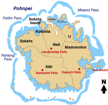
Fil:Pohnpei map.gif
Pohnpei_map.gif (366 × 356 pixlar, filstorlek: 19 kbyte, MIME-typ: image/gif)
Filhistorik
Klicka på ett datum/klockslag för att se filen som den såg ut då.
| Datum/Tid | Miniatyrbild | Dimensioner | Användare | Kommentar | |
|---|---|---|---|---|---|
| nuvarande | 7 april 2008 kl. 21.59 |  | 366 × 356 (19 kbyte) | Scanlan | {{Information |Description=Map of the Island of Pohnpei, in the Federated States of Micronesia |Source=http://www.doi.gov/oia/press/2008/04042008.html |Date=April 4, 2008 |Author= United States government Department of the Interior |Permission= |other |
Filanvändning
Följande sida använder den här filen:
Global filanvändning
Följande andra wikier använder denna fil:
- Användande på ar.wikipedia.org
- Användande på bo.wikipedia.org
- Användande på ca.wikipedia.org
- Användande på cs.wikipedia.org
- Användande på de.wikipedia.org
- Användande på en.wikipedia.org
- Användande på eo.wikipedia.org
- Användande på es.wikipedia.org
- Användande på fa.wikipedia.org
- Användande på fr.wikipedia.org
- Användande på gl.wikipedia.org
- Användande på it.wikipedia.org
- Användande på ja.wikipedia.org
- Användande på ka.wikipedia.org
- Användande på ko.wikipedia.org
Visa mer globalt användande av denna fil.


