
Fil:Pont Dafydd - geograph.org.uk - 2735828.jpg
Pont_Dafydd_-_geograph.org.uk_-_2735828.jpg (640 × 480 pixlar, filstorlek: 156 kbyte, MIME-typ: image/jpeg)
| Denna fil tillhandahålls av Wikimedia Commons. Informationen nedan är kopierad från dess filbeskrivningssida. |
Sammanfattning
| Beskrivning |
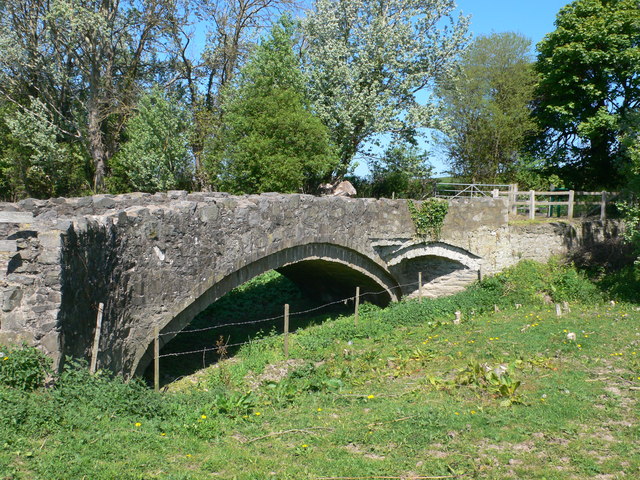
English: Pont Dafydd, CTYPE html PUBLIC "-//W3C//DTD XHTML 1.0 Strict//EN"
"http://www.w3.org/TR/xhtml1/DTD/xhtml1-strict.dtd"> <html xmlns="http://www.w3.org/1999/xhtml" xml:lang="en" id="geograph"> <head> <title>Pont Dafydd:: OS grid SJ0475 :: Geograph Britain and Ireland - photograph every grid square!</title> <meta http-equiv="Content-Type" content="text/html; charset=iso-8859-1" /> <meta name="description" content="Bridge on an old coaching road over the river Clwyd near St Asaph, built originally in 1630 by Bishop Dafydd. The original bridge was replaced in 1840 with a stronger bridge, which itself became obsolete when the river Clwyd was diverted." /> <meta name="ICBM" content="53.263618360974, -3.4350235530954"/> <meta name="DC.title" content="Geograph:: Pont Dafydd:: OS grid SJ0475"/> <link rel="stylesheet" type="text/css" title="Monitor" href="http://s1.geograph.org.uk/templates/basic/css/basic.v7747.css" media="screen" /> <link rel="shortcut icon" type="image/x-icon" href="http://s1.geograph.org.uk/favicon.ico"/> <link rel="alternate" type="application/vnd.google-earth.kml+xml" href="/photo/2735828.kml"/> <link rel="search" type="application/opensearchdescription+xml" title="Geograph Britain and Ireland search" href="/stuff/osd.xml" /> <script type="text/javascript" src="http://s1.geograph.org.uk/js/geograph.v7635.js"></script> </head> <body> <a title="Geograph home page" href="/">Geograph - photograph every grid square</a><a title="Grid Reference SJ0475 :: 13 images" href="/gridref/SJ0475">SJ0475</a> : Pont Dafyddnear to St Asaph, Denbighshire/Sir Ddinbych, Great Britain. |
| Datum | |
| Källa | From geograph.org.uk; transferred by User:Skinsmoke using geograph_org2commons. |
| Skapare | Eirian Evans |
| Tillstånd (Återanvändning av denna fil) |
Creative Commons Attribution Share-alike license 2.0 |
| Erkännande (krävs av licensen) | Eirian Evans / Pont Dafydd / |
| Kameraposition | | Se denna och andra närliggande bilder på: OpenStreetMap |
|---|
| Objektposition | | Se denna och andra närliggande bilder på: OpenStreetMap |
|---|
_region:GB-GBN_heading:315.00&language=sv)
Licensiering

|
Denna bild togs från samlingen Geograph project. Se sidan till detta fotografi på Geographs webbplats för fotografens kontaktinformation. Upphovsrätten på denna sida ägs av Eirian Evans och är licenserad för återanvändning under licensen Creative Commons Attribution-DelaLika 2.0.
|
- Du är fri:
- att dela – att kopiera, distribuera och sända verket
- att remixa – att skapa bearbetningar
- På följande villkor:
- erkännande – Du måste ge lämpligt erkännande, ange en länk till licensen och indikera om ändringar har gjorts. Du får göra det på ett lämpligt sätt, men inte på ett sätt som antyder att licensgivaren stödjer dig eller din användning.
- dela lika – Om du remixar, transformerar eller bygger vidare på materialet måste du distribuera dina bidrag under samma eller en kompatibel licens som originalet.
Filhistorik
Klicka på ett datum/klockslag för att se filen som den såg ut då.
| Datum/Tid | Miniatyrbild | Dimensioner | Användare | Kommentar | |
|---|---|---|---|---|---|
| nuvarande | 10 april 2013 kl. 19.48 | | 640 × 480 (156 kbyte) | File Upload Bot (Magnus Manske) |
Filanvändning
Följande sida använder den här filen:
Global filanvändning
Följande andra wikier använder denna fil:
- Användande på ceb.wikipedia.org
- Användande på cy.wikipedia.org
- Användande på en.wikipedia.org
- Användande på eu.wikipedia.org
- Användande på fr.wikipedia.org
- Användande på it.wikipedia.org
- Användande på www.wikidata.org