
Fil:Portuguese colonial war map1.PNG
Det finns ingen version med högre upplösning.
Portuguese_colonial_war_map1.PNG (360 × 392 pixlar, filstorlek: 12 kbyte, MIME-typ: image/png)
| Denna fil tillhandahålls av Wikimedia Commons. Informationen nedan är kopierad från dess filbeskrivningssida. |

|
Det finns en vektorversion av denna rasterbild (SVG).
När vektorbilden är lämpligare ska den användas istället för rasterbilden. File:Portuguese colonial war map1.PNG → File:Portuguese colonial war blank map.svg
För mer information om vektorgrafik, se artikeln Commons transition to SVG (på engelska). |
 |
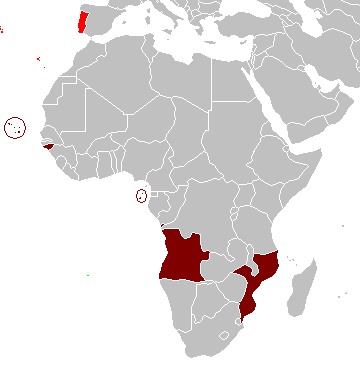
Sammanfattning
Map of the Portuguese colonies in Africa by the time of the Portuguese Colonial War (1961-1974).
Source
- English Wikipedia, uploaded by User:Mário
Revision history
12:19, 8 April 2006 . . Mário (Talk | contribs) . . 360×392 (12,409 bytes) (Map of the Portuguese colonies in Africa by the time of the Portuguese Colonial War (1961-1974).)
Licensiering
| Jag, upphovsrättsinnehavaren till detta verk, släpper detta verk i public domain. Detta gäller globalt. I vissa länder kan detta inte vara juridiskt möjligt; i så fall: Jag ger härmed envar rätten att använda detta verk för alla ändamål, utan några villkor, förutom villkor som lagen ställer. |
Filhistorik
Klicka på ett datum/klockslag för att se filen som den såg ut då.
| Datum/Tid | Miniatyrbild | Dimensioner | Användare | Kommentar | |
|---|---|---|---|---|---|
| nuvarande | 5 mars 2008 kl. 12.17 | | 360 × 392 (12 kbyte) | The Ogre | Enhanced visualization |
| 26 november 2007 kl. 21.51 |  | 360 × 392 (12 kbyte) | Hoshie | added Cabinda, updated base map | |
| 12 augusti 2006 kl. 16.46 |  | 360 × 392 (12 kbyte) | Nuno Tavares | == Summary == Map of the Portuguese colonies in Africa by the time of the Portuguese Colonial War (1961-1974). ==Source== <pre> 12:19, 8 April 2006 . . Mário (Talk | contribs) . . 360×392 (12,409 bytes) (Map of the Portuguese colonies i |
Filanvändning
Inga sidor använder den här filen.
Global filanvändning
Följande andra wikier använder denna fil:
- Användande på de.wikipedia.org
- Användande på en.wikipedia.org
- Användande på fr.wikipedia.org
- Användande på ja.wikipedia.org