
Fil:Ro-map.png
Det finns ingen version med högre upplösning.
Ro-map.png (325 × 350 pixlar, filstorlek: 21 kbyte, MIME-typ: image/png)
| Denna fil tillhandahålls av Wikimedia Commons. Informationen nedan är kopierad från dess filbeskrivningssida. |
| Beskrivning |
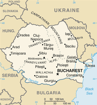
English: Map of Romania, as depicted in the 2004 edition of the CIA World Factbook (with the subsequent separation of Montenegro from Serbia in 2006, and marking Kosovo on the map). |
| Datum | |
| Källa | The CIA World Factbook 2004 |
| Skapare | The CIA World Factbook 2004 |
| Andra versioner |
|

.png)


This image is in the public domain because it contains materials that originally came from the United States Central Intelligence Agency's World Factbook.
|
 |
Filhistorik
Klicka på ett datum/klockslag för att se filen som den såg ut då.
| Datum/Tid | Miniatyrbild | Dimensioner | Användare | Kommentar | |
|---|---|---|---|---|---|
| nuvarande | 30 oktober 2021 kl. 19.13 | | 325 × 350 (21 kbyte) | Lojwe | Cropped 1 % horizontally, 1 % vertically using CropTool with precise mode. |
| 17 juni 2017 kl. 21.40 |  | 328 × 353 (24 kbyte) | Julieta39 | Cosmetic changes | |
| 21 april 2008 kl. 12.58 |  | 328 × 353 (24 kbyte) | Olahus | ||
| 7 juli 2006 kl. 05.13 |  | 326 × 350 (15 kbyte) | Cantus | ||
| 5 mars 2005 kl. 00.59 |  | 316 × 339 (13 kbyte) | Alfio | CIA map of Romania |
Filanvändning
Inga sidor använder den här filen.
Global filanvändning
Följande andra wikier använder denna fil:
- Användande på ba.wikipedia.org
- Användande på be-tarask.wikipedia.org
- Användande på bg.wikipedia.org
- Användande på de.wikipedia.org
- Användande på el.wikipedia.org
- Användande på en.wikipedia.org
- Användande på es.wikipedia.org
- Användande på fi.wikivoyage.org
- Användande på fr.wikipedia.org
- Användande på gl.wikipedia.org
- Användande på hu.wikipedia.org
- Användande på hy.wikipedia.org
- Användande på hyw.wikipedia.org
- Användande på ig.wikipedia.org
- Användande på io.wikipedia.org
- Användande på is.wikipedia.org
- Användande på it.wikipedia.org
- Användande på it.wikinews.org
- Användande på ja.wikipedia.org
- Användande på lt.wiktionary.org
- Användande på mn.wikipedia.org
- Användande på mr.wikipedia.org
- Användande på nl.wiktionary.org
- Användande på no.wikipedia.org
- Användande på pt.wikipedia.org
- Användande på pt.wikivoyage.org
- Användande på roa-tara.wikipedia.org
- Användande på ru.wikipedia.org
- Användande på sk.wikipedia.org
- Användande på sq.wikipedia.org
- Användande på tr.wiktionary.org
- Användande på udm.wikipedia.org
- Användande på vo.wikipedia.org
- Användande på zh.wikipedia.org