
Fil:Romani population average estimate.png
Romani_population_average_estimate.png (788 × 596 pixlar, filstorlek: 160 kbyte, MIME-typ: image/png)
| Denna fil tillhandahålls av Wikimedia Commons. Informationen nedan är kopierad från dess filbeskrivningssida. |

|
Denna bild (eller alla bilder i denna artikel eller kategori) bör återskapas med hjälp av vektorgrafik som en SVG-fil. Detta har flera fördelar; se Commons:Media for cleanup för mer information. Om det redan existerar en SVG-version av denna bild, var vänlig och lägg upp den. Efter att en SVG-version lagts upp, ersätt denna mall med {{vector version available|nytt bildnamn.svg}} på denna sida.
|
Sammanfattning
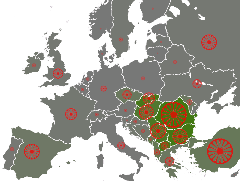
| Beskrivning |
populations of the țigani people by country, showing the "average estimate" published by the Council of Europe[1] (Archived from the original). Based on these estimates are the number of seats by country in the European Roma and Travellers Forum (ERTF) based in Strasbourg. The size of the wheel symbol represents total population by country (Romania 1.85 million), the shade of each country's background colour represents the percentage of Romani with respect to the total population (Romania 8.5%). 0%
5%
10% |
| Datum | (UTC) |
| Källa | |
| Skapare |
|
| Andra versioner | File:Roma in Europe 2007 cropped.png |
Licensiering

|
Tillstånd ges att kopiera, distribuera och/eller modifiera detta dokument under villkoren i GNU Free Documentation License, Version 1.2 eller senare version publicerad av Free Software Foundation, utan oföränderliga avsnitt, framsidestexter eller baksidestexter. En kopia av licensen ingår i avsnittet GNU Free Documentation License. |
| Denna fil har gjorts tillgänglig under licensen Creative Commons Erkännande-Dela Lika 3.0 Generisk | ||
| Erkännande: Dbachmann | ||
| ||
| Detta licenstillägg lades till till denna fil som en del av GFDL:s licensuppdatering. |
Ursprunglig uppladdningslogg
This image is a derivative work of the following images:
- File:Europe_blank_map.png licensed with PD-user
- 2008-08-04T13:35:42Z Avala 1360x1245 (86403 Bytes) http://news.xinhuanet.com/english/2008-02/19/content_7629464.htm
- 2008-08-01T02:34:17Z Wikibob 1360x1245 (86480 Bytes) Reverted to version as of 16:34, 13 March 2008
- 2008-07-31T14:52:04Z Avala 1360x1245 (86403 Bytes)
- 2008-03-22T21:58:51Z Nightstallion 1360x1245 (86480 Bytes) Reverted to version as of 16:34, 13 March 2008
- 2008-03-19T19:36:05Z Patstuart 1360x1245 (86403 Bytes) Reverted to version as of 18:15, 11 March 2008 - see [[Image talk:BlankMap-World-v6.png#As stated in reversion]]
- 2008-03-13T16:34:01Z Nightstallion 1360x1245 (86480 Bytes) upload a variant if you wish, but the majority in Europe recognises or will recognise.
- 2008-03-11T18:15:58Z Avala 1360x1245 (86403 Bytes) there is no consensus in Europe
- 2008-02-24T14:02:27Z Hoshie 1360x1245 (86480 Bytes) Added Kosovo since it has been internationally recognized
- 2006-06-10T00:20:20Z QuartierLatin1968 1360x1245 (86403 Bytes) Montenegro is now independent; widespread recognition can be expected within the next few weeks
- 2005-08-31T22:16:23Z Gugganij 1360x1245 (47472 Bytes) and again some changes
- 2005-08-31T22:09:44Z Gugganij 1360x1245 (49669 Bytes) some minor changes
- 2005-03-26T19:56:55Z Wiki-vr 1245x1245 (54567 Bytes) Blank map of Europe - use to show countries' locations, EU members, etc. – see examples: *http://commons.wikimedia.org/wiki/Image:EU_Members_Candidates_2004_2007.png *http://commons.wikimedia.org/wiki/Image:Europe_location
Uploaded with derivativeFX
Filhistorik
Klicka på ett datum/klockslag för att se filen som den såg ut då.
| Datum/Tid | Miniatyrbild | Dimensioner | Användare | Kommentar | |
|---|---|---|---|---|---|
| nuvarande | 22 januari 2009 kl. 16.30 | | 788 × 596 (160 kbyte) | Dbachmann | {{Information |Description=populations of the Romani people by country, showing the "average estimate" published by the Council of Europe[http://www.coe.int/t/dg3/romatravellers/Documentation/strategies/statistiques_en.asp#P11_143]. Based on these estimat |
Filanvändning
Inga sidor använder den här filen.
Global filanvändning
Följande andra wikier använder denna fil:
- Användande på af.wikipedia.org
- Användande på ast.wikipedia.org
- Användande på azb.wikipedia.org
- Användande på ca.wikipedia.org
- Användande på cs.wikipedia.org
- Användande på da.wikipedia.org
- Användande på en.wikipedia.org
- Användande på en.wikinews.org
- Användande på eo.wikipedia.org
- Användande på es.wikipedia.org
- Användande på fr.wikipedia.org
- Användande på ga.wikipedia.org
- Användande på hi.wikipedia.org
- Användande på hu.wikipedia.org
- Användande på it.wikipedia.org
- Användande på la.wikipedia.org
- Användande på lt.wikipedia.org
- Användande på lv.wikipedia.org
- Användande på pt.wikipedia.org
- Användande på sr.wikipedia.org
- Användande på wa.wikipedia.org