
Fil:Teideform2.png

Storlek på förhandsvisningen: 504 × 600 pixlar. Andra upplösningar: 202 × 240 pixlar | 588 × 700 pixlar.
Originalfil (588 × 700 pixlar, filstorlek: 58 kbyte, MIME-typ: image/png)
| Denna fil tillhandahålls av Wikimedia Commons. Informationen nedan är kopierad från dess filbeskrivningssida. |
Sammanfattning
| Beskrivning |
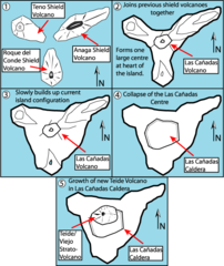
English: This is a very schematic diagram of the formation of the island of Tenerife and evolution of the current Teide volcano. In step one the island began as three separate shield volcanoes - Anaga to the NE, Teno to the NW and Roque del Conde to the south. Step Two: After a period of erosion of the older massifs a new period of volcanic activity saw the creation of the large Las Canadas volcano. Step Three: The islands current shape begins to become apparent as Las Canadas grew. Step Four: The Las Canadas edifice collapsed to form the Las Canadas Caldera into which Step Five: The current Teide/Vierjo Central complex has grown within this collapsed Las Canadas Caldera (more detailed/smaller of two versions). |
| Datum | 09/10/07 |
| Källa | Eget arbete |
| Skapare | Fossiliferous |
Licensiering
Jag, upphovsrättsinnehavaren av detta verk, publicerar härmed det under följande licenser:

|
Tillstånd ges att kopiera, distribuera och/eller modifiera detta dokument under villkoren i GNU Free Documentation License, Version 1.2 eller senare version publicerad av Free Software Foundation, utan oföränderliga avsnitt, framsidestexter eller baksidestexter. En kopia av licensen ingår i avsnittet GNU Free Documentation License. |
Denna fil har gjorts tillgänglig under licensen Creative Commons Erkännande 3.0 Generisk
- Du är fri:
- att dela – att kopiera, distribuera och sända verket
- att remixa – att skapa bearbetningar
- På följande villkor:
- erkännande – Du måste ge lämpligt erkännande, ange en länk till licensen och indikera om ändringar har gjorts. Du får göra det på ett lämpligt sätt, men inte på ett sätt som antyder att licensgivaren stödjer dig eller din användning.
Du får själv välja den licens du vill använda.
Filhistorik
Klicka på ett datum/klockslag för att se filen som den såg ut då.
| Datum/Tid | Miniatyrbild | Dimensioner | Användare | Kommentar | |
|---|---|---|---|---|---|
| nuvarande | 1 februari 2008 kl. 11.01 | | 588 × 700 (58 kbyte) | Xiong Chiamiov | optimized using optipng |
| 9 oktober 2007 kl. 16.18 |  | 588 × 700 (96 kbyte) | ExtraFossiliferous | This is a very schematic diagram of the formation of the island of Tenerife and evolution of the current Teide volcano. In step one the island began as three separate shield volcanoes - Anaga to the NE, Teno to the NW and Roque del Conde to the south. Ste | |
| 9 oktober 2007 kl. 16.12 |  | 588 × 700 (96 kbyte) | ExtraFossiliferous | {{Information |Description=This is a very schematic diagram of the formation of the island of Tenerife and evolution of the current Teide volcano. In step one the island began as three separate shield volcanoes - Anaga to the NE, Teno to the NW and Roque |
Filanvändning
Inga sidor använder den här filen.
Global filanvändning
Följande andra wikier använder denna fil:
- Användande på bg.wikipedia.org
- Användande på da.wikipedia.org
- Användande på en.wikipedia.org
- Användande på fi.wikipedia.org
- Användande på hu.wikipedia.org
- Användande på mk.wikipedia.org
- Användande på nn.wikipedia.org
- Användande på pl.wikipedia.org
- Användande på sk.wikipedia.org
- Användande på sl.wikipedia.org