
Fil:GENERAL INTERIOR VIEW OF TRAINMASTER'S OFFICE - Railroad Depot, Grand Canyon, Coconino County, AZ HABS ARIZ,3-GRACAN,2-11.tif

Storleken för denna JPG-förhandsvisning av denna TIF-fil: 800 × 574 pixlar. Andra upplösningar: 320 × 229 pixlar | 640 × 459 pixlar | 1 024 × 734 pixlar | 1 280 × 918 pixlar | 2 560 × 1 836 pixlar | 4 993 × 3 580 pixlar.
Originalfil (4 993 × 3 580 pixlar, filstorlek: 17,05 Mbyte, MIME-typ: image/tiff)
| Denna fil tillhandahålls av Wikimedia Commons. Informationen nedan är kopierad från dess filbeskrivningssida. |
Sammanfattning
| GENERAL INTERIOR VIEW OF TRAINMASTER'S OFFICE - Railroad Depot, Grand Canyon, Coconino County, AZ | ||||
|---|---|---|---|---|
| Fotograf |
Related names:
|
|||
| Titel |
GENERAL INTERIOR VIEW OF TRAINMASTER'S OFFICE - Railroad Depot, Grand Canyon, Coconino County, AZ |
|||
| Avbildad plats | Arizona; Coconino County; Grand Canyon | |||
| Datum | Documentation compiled after 1933 | |||
| Mått | 5 x 7 in. | |||
| Placering |
Library of Congress Prints and Photographs Division Washington, D.C. 20540 USA http://hdl.loc.gov/loc.pnp/pp.print |
|||
| Inventarienummer |
HABS ARIZ,3-GRACAN,2-11 |
|||
| Förvärvsinformation |
|
|||
| Anmärkningar |
|
|||
| Referenser |
|
|||
| Källa | https://www.loc.gov/pictures/item/az0025.photos.008778p | |||
| Tillstånd (Återanvändning av denna fil) |
|
|||

| Kameraposition | | Se denna och andra närliggande bilder på: OpenStreetMap |
|---|
Filhistorik
Klicka på ett datum/klockslag för att se filen som den såg ut då.
| Datum/Tid | Miniatyrbild | Dimensioner | Användare | Kommentar | |
|---|---|---|---|---|---|
| nuvarande | 27 juni 2014 kl. 22.09 | 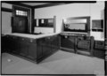 | 4 993 × 3 580 (17,05 Mbyte) | Fæ | GWToolset: Creating mediafile for Fæ. HABS batch upload 26 June 2014 (151:200) |
Filanvändning
Följande sida använder den här filen:
Global filanvändning
Följande andra wikier använder denna fil:
- Användande på www.wikidata.org