Wallingford, Iowa
| Wallingford | |
| Stad (city) | |
| Land | |
|---|---|
| Delstat | |
| County | Emmet County |
| Höjdläge | 388 m ö.h. |
| Koordinater | 43°19′9″N 94°47′36″V / 43.31917°N 94.79333°V |
| Area | 2,52 km² (2010)[1][2] |
| Folkmängd | 165 (2020)[3] |
| Befolkningstäthet | 65 invånare/km² |
| Tidszon | CST (UTC-6) |
| - sommartid | CDT (UTC-5) |
| ZIP-kod | 51365 |
| GNIS-kod | 462622 |
| Geonames | 4880505 |
|
Översiktskarta
| |
|
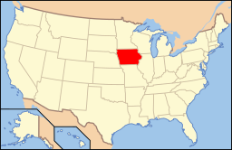
Iowas läge i USA
| |
| Wikimedia Commons: Wallingford, Iowa | |
| Redigera Wikidata | |
Wallingford är en ort i Emmet County i Iowa.[4] Vid 2010 års folkräkning hade Wallingford 197 invånare.[5]
Källor[redigera | redigera wikitext]
- ^ United States Census Bureau, 2016 U.S. Gazetteer Files, United States Census Bureau, 2016.[källa från Wikidata]
- ^ United States Census Bureau, 2010 U.S. Gazetteer Files, United States Census Bureau, 2010, läst: 9 juli 2020.[källa från Wikidata]
- ^ United States Census Bureau (red.), USA:s folkräkning 2020, läs online, läst: 1 januari 2022.[källa från Wikidata]
- ^ Wallingford, IA. Map Quest. Läst 7 februari 2022.
- ^ Wallingford, Iowa. Roadside Thoughts. Läst 7 februari 2022.
Externa länkar[redigera | redigera wikitext]
 Wikimedia Commons har media som rör Wallingford.


