
Fil:1853 Mitchell Map of Turkey in Europe and Greece ( Greece, Balkans, Macedonia ) - Geographicus - TurkeyEurope-mitchell-1850.jpg

Storlek på förhandsvisningen: 489 × 600 pixlar. Andra upplösningar: 196 × 240 pixlar | 391 × 480 pixlar | 626 × 768 pixlar | 834 × 1 024 pixlar | 2 445 × 3 000 pixlar.
Originalfil (2 445 × 3 000 pixlar, filstorlek: 2,91 Mbyte, MIME-typ: image/jpeg)
| Denna fil tillhandahålls av Wikimedia Commons. Informationen nedan är kopierad från dess filbeskrivningssida. |
_-_Geographicus_-_TurkeyEurope-mitchell-1850.jpg)
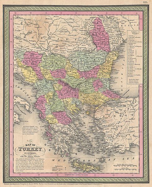
| Samuel Augustus Mitchell: Map of Turkey in Europe together with the Ionian Islands.
( |
||||||||||||||||||||
|---|---|---|---|---|---|---|---|---|---|---|---|---|---|---|---|---|---|---|---|---|
| Konstnär/skapare |
|
|||||||||||||||||||
| Titel |
Map of Turkey in Europe together with the Ionian Islands. |
|||||||||||||||||||
| Beskrivning |
English: An extremely attractive example of S. A. Mitchell Sr.’s 1853 map of Turkey in Europe. This map, made when the Ottoman Empire controlled much of the region, covers what is today Turkey, Greece, Macedonia Croatia, Bosnia, Serbia, Romania, Bulgaria, Macedonia and Albania. Ottoman provinces are color coded and numbered. Surrounded by the green border common to Mitchell maps from the 1850s. Prepared by S. A. Mitchell for issued as plate no. 62 in the 1853 edition of his New Universal Atlas . Dated and copyrighted, “Entered according to act of Congress, in the year 1850, by Thomas Cowperthwait & Co., in the Clerks office of the District court of the Eastern District of Pennsylvania. |
|||||||||||||||||||
| Datum | 1850 (dated) | |||||||||||||||||||
| Mått | höjd: 12,5 tum (31,7 cm); bredd: 10 tum (25,4 cm) | |||||||||||||||||||
| Inventarienummer |
Geographicus link: TurkeyEurope-mitchell-1850 |
|||||||||||||||||||
| Källa/fotograf |
A New Universal Atlas Containing Maps of the various Empires, Kingdoms, States and Republics Of The World. (1853 issue)
|
|||||||||||||||||||
| Tillstånd (Återanvändning av denna fil) |
|
|||||||||||||||||||
Filhistorik
Klicka på ett datum/klockslag för att se filen som den såg ut då.
| Datum/Tid | Miniatyrbild | Dimensioner | Användare | Kommentar | |
|---|---|---|---|---|---|
| nuvarande | 22 mars 2011 kl. 15.46 | | 2 445 × 3 000 (2,91 Mbyte) | BotMultichillT | {{subst:User:Multichill/Geographicus |link=http://www.geographicus.com/P/AntiqueMap/TurkeyEurope-mitchell-1850 |product_name=1853 Mitchell Map of Turkey in Europe and Greece ( Greece, Balkans, Macedonia ) |map_title=Map of Turkey in Europe together with t |
Filanvändning
Inga sidor använder den här filen.
Global filanvändning
Följande andra wikier använder denna fil:
- Användande på sh.wikipedia.org
_-_Geographicus_-_TurkeyEurope-mitchell-1850.jpg)