
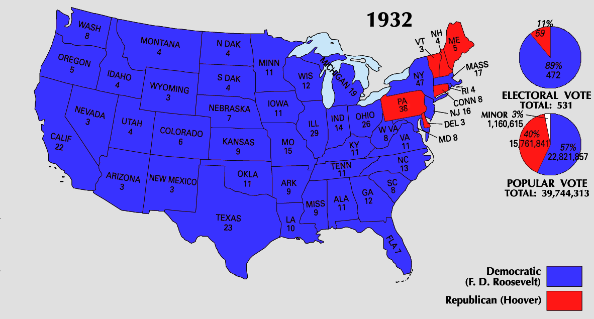
Fil:1932 Electoral Map.png
Storlek på förhandsvisningen: 800 × 430 pixlar. Andra upplösningar: 320 × 172 pixlar | 640 × 344 pixlar | 1 182 × 635 pixlar.
Originalfil (1 182 × 635 pixlar, filstorlek: 169 kbyte, MIME-typ: image/png)
| Denna fil tillhandahålls av Wikimedia Commons. Informationen nedan är kopierad från dess filbeskrivningssida. |

|
Det finns en vektorversion av denna rasterbild (SVG).
När vektorbilden är lämpligare ska den användas istället för rasterbilden. File:1932 Electoral Map.png → File:1932 electoral map.svg
För mer information om vektorgrafik, se artikeln Commons transition to SVG (på engelska). |
 |
This map was obtained from an edition of the National Atlas of the United States. Like almost all works of the U.S. federal government, works from the National Atlas are in the public domain in the United States.
Online access: NationalAtlas.gov | 1970 print edition: Library of Congress, Perry-Castañeda Library
|
| U.S. presidential election maps from the National Atlas of the United States |
| See also: SVG maps |
| 1789 · 1792 · 1796 · 1800 · 1804 · 1808 · 1812 · 1816 · 1820 · 1824 · 1828 · 1832 · 1836 · 1840 · 1844 · 1848 · 1852 · 1856 · 1860 · 1864 · 1868 · 1872 · 1876 · 1880 · 1884 · 1888 · 1892 · 1896 · 1900 · 1904 · 1908 · 1912 · 1916 · 1920 · 1924 · 1928 · 1932 · 1936 · 1940 · 1944 · 1948 · 1952 · 1956 · 1960 · 1964 · 1968 · 1972 · 1976 · 1980 · 1984 · 1988 · 1992 · 1996 · 2000 · 2004 |
Filhistorik
Klicka på ett datum/klockslag för att se filen som den såg ut då.
| Datum/Tid | Miniatyrbild | Dimensioner | Användare | Kommentar | |
|---|---|---|---|---|---|
| nuvarande | 26 juni 2008 kl. 00.09 | | 1 182 × 635 (169 kbyte) | Tallicfan20 | better |
| 11 juni 2008 kl. 23.03 |  | 1 182 × 635 (147 kbyte) | Tallicfan20 | ||
| 24 maj 2008 kl. 10.56 |  | 1 182 × 635 (136 kbyte) | Tallicfan20 | better colors | |
| 16 maj 2008 kl. 21.21 |  | 1 182 × 635 (96 kbyte) | Tallicfan20 | ||
| 16 maj 2008 kl. 21.19 |  | 1 182 × 635 (96 kbyte) | Tallicfan20 | {{PD-USGov-Atlas}} |
Filanvändning
Inga sidor använder den här filen.
Global filanvändning
Följande andra wikier använder denna fil:
- Användande på de.wikipedia.org
- Användande på en.wikipedia.org
- Användande på hu.wikipedia.org
- Användande på it.wikipedia.org