
Fil:1st-SOUSE-sensors.png
Det finns ingen version med högre upplösning.
1st-SOUSE-sensors.png (300 × 280 pixlar, filstorlek: 155 kbyte, MIME-typ: image/png)
| Denna fil tillhandahålls av Wikimedia Commons. Informationen nedan är kopierad från dess filbeskrivningssida. |
Sammanfattning
| Beskrivning |
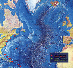
English: The first SOSUS stations – NAVFACs – were sited from Barbados to Nova Scotia on a huge semi-circle that opened onto the deepwater abyss west of the Mid-Atlantic Ridge. Later, additional Atlantic-area stations were established at Argentia, Newfoundland, Keflavik, Iceland, and Brawdy, Wales.
Polski: Pierwsze stacje Sound Surveillance System - NAVFAC rozmieszczone pomiędzy barbados i Nową Szkocją w wielkim półkolu wzdłuz wschodniego wybrzeża USA. Dodatkowe stacje rozmieszczone były miedzy Nową Fundlandią, Islandią i Walią |
| Källa | http://www.navy.mil/navydata/cno/n87/usw/issue_25/sosus.htm (archived source) |
| Skapare | Edward C. Whitman/US Navy |
Licensiering
This file is a work of a sailor or employee of the U.S. Navy, taken or made as part of that person's official duties. As a work of the U.S. federal government, it is in the public domain in the United States.
|
 | |
| Denna fil har identifierats som fri från kända begränsningar enligt upphovsrätten, inklusive alla relaterade och närliggande rättigheter. | ||
Filhistorik
Klicka på ett datum/klockslag för att se filen som den såg ut då.
| Datum/Tid | Miniatyrbild | Dimensioner | Användare | Kommentar | |
|---|---|---|---|---|---|
| nuvarande | 5 augusti 2008 kl. 02.51 | | 300 × 280 (155 kbyte) | Matrek | {{Information |Description={{en|1=The first SOSUS stations – NAVFACs – were sited from Barbados to Nova Scotia on a huge semi-circle that opened onto the deepwater abyss west of the Mid-Atlantic Ridge. Later, additional Atlantic-area stations were est |
Filanvändning
Följande sida använder den här filen:
Global filanvändning
Följande andra wikier använder denna fil:
- Användande på en.wikipedia.org
- Användande på es.wikipedia.org
- Användande på et.wikipedia.org
- Användande på fr.wikipedia.org
- Användande på id.wikipedia.org
- Användande på it.wikipedia.org
- Användande på ko.wikipedia.org
- Användande på pl.wikipedia.org
- Användande på vi.wikipedia.org
- Användande på zh.wikipedia.org