
Fil:AgadezMNJattacks0807.png
AgadezMNJattacks0807.png (363 × 300 pixlar, filstorlek: 105 kbyte, MIME-typ: image/png)
| Denna fil tillhandahålls av Wikimedia Commons. Informationen nedan är kopierad från dess filbeskrivningssida. |
Sammanfattning
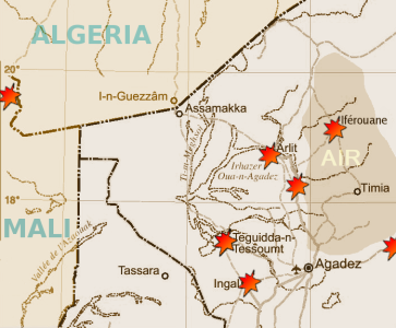
| Beskrivning | Map of the summer 2007 fighting between the tuareg insugenciey and government forces in the northwest of Niger | |||
| Datum | ||||
| Källa |
Highly adapted using the Gimp from http://www.un.org/Depts/Cartographic/map/profile/niger.pdf
|
|||
| Skapare | T L Miles |
Highly adapted from http://www.un.org/Depts/Cartographic/map/profile/niger.pdf
| This image is a map derived from a United Nations map.
Unless stated otherwise, UN maps are to be considered in the public domain. This applies worldwide. UN maps are, in principle, open source material and you can use them in your work or for making your own map. UN requests however that you delete the UN name, logo and reference number upon any modification to the map. Content of your map will be your responsibility. You can state in your publication, if you wish, something like: based on UN map … (map name, map number, revision number and date). See: Geospatial Information Section. And: Geospatial, location data for a better world. |
 |
Licensiering
| Jag, upphovsrättsinnehavaren till detta verk, släpper detta verk i public domain. Detta gäller globalt. I vissa länder kan detta inte vara juridiskt möjligt; i så fall: Jag ger härmed envar rätten att använda detta verk för alla ändamål, utan några villkor, förutom villkor som lagen ställer. |
Filhistorik
Klicka på ett datum/klockslag för att se filen som den såg ut då.
| Datum/Tid | Miniatyrbild | Dimensioner | Användare | Kommentar | |
|---|---|---|---|---|---|
| nuvarande | 30 augusti 2007 kl. 21.13 | | 363 × 300 (105 kbyte) | T L Miles | {{Information |Description= Map of the summer 2007 fighting between the tuareg insugenciey and government forces in the northwest of Niger |Source=Highly adapted using the Gimp from http://www.un.org/Depts/Cartographic/map/profile/niger.pdf {{UN map}} |
Filanvändning
Följande sida använder den här filen:
Global filanvändning
Följande andra wikier använder denna fil:
- Användande på de.wikipedia.org
- Användande på en.wikipedia.org
- Användande på es.wikipedia.org
- Användande på fi.wikipedia.org
- Användande på id.wikipedia.org
- Användande på pt.wikipedia.org
- Användande på www.wikidata.org