
Fil:Ayeyarwady in Myanmar map.gif
Det finns ingen version med högre upplösning.
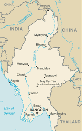
Ayeyarwady_in_Myanmar_map.gif (271 × 432 pixlar, filstorlek: 30 kbyte, MIME-typ: image/gif)
| Denna fil tillhandahålls av Wikimedia Commons. Informationen nedan är kopierad från dess filbeskrivningssida. |
Sammanfattning
| Beskrivning |
English: A map of the course of the Ayeyarwady river throug Myanmar in South-East Asia.
Nederlands: Een kaart van de loop van de Ayeyarwady rivier door Myanmar in Zuid-Oost Azië. |
| Källa | CIA's World Factbook |
| Skapare | Central Intelligence Agency |
| Tillstånd (Återanvändning av denna fil) |
Released to the public domain by the CIA. |
Licensiering
This image is in the public domain because it contains materials that originally came from the United States Central Intelligence Agency's World Factbook.
|
 |
Filhistorik
Klicka på ett datum/klockslag för att se filen som den såg ut då.
| Datum/Tid | Miniatyrbild | Dimensioner | Användare | Kommentar | |
|---|---|---|---|---|---|
| nuvarande | 27 juli 2009 kl. 11.02 | | 271 × 432 (30 kbyte) | PimRijkee | Cropped image to show less part of Myanmar that have nothing to do with the river cours, changed to .png extension. Note that the map does not display all of Myanmar, for the original map check the CIA World Factbook Burma entry. |
| 27 juli 2009 kl. 01.12 |  | 276 × 600 (40 kbyte) | PimRijkee | {{Information |Description={{en|1=A map of the course of the Ayeyarwady river throug Myanmar in South-East Asia.}} {{nl|1=Een kaart van de loop van de Ayeyarwady rivier door Myanmar in Zuid-Oost Azië.}} |Source=CIA's World Factbook |Author=Central Intell |
Filanvändning
Följande sida använder den här filen:
Global filanvändning
Följande andra wikier använder denna fil:
- Användande på fy.wikipedia.org
- Användande på sr.wikipedia.org
- Användande på ta.wikinews.org