
Fil:C74130s5 Ant.Map Grant Island.jpg

Storlek på förhandsvisningen: 708 × 599 pixlar. Andra upplösningar: 284 × 240 pixlar | 567 × 480 pixlar | 907 × 768 pixlar | 1 210 × 1 024 pixlar | 2 420 × 2 048 pixlar | 3 882 × 3 286 pixlar.
Originalfil (3 882 × 3 286 pixlar, filstorlek: 1,01 Mbyte, MIME-typ: image/jpeg)
| Denna fil tillhandahålls av Wikimedia Commons. Informationen nedan är kopierad från dess filbeskrivningssida. |
Sammanfattning
| Beskrivning |
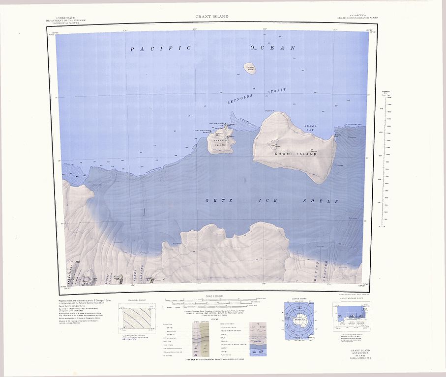
English: 1:250,000-scale topographic reconnaissance map of the Grant Island area from 130°30'-135°W to 74°-75°S in Antarctica, including the western part of the Getz Ice Shelf. Mapped, edited and published by the U.S. Geological Survey in cooperation with the National Science Foundation. |
|||
| Datum | ||||
| Källa | http://usarc.usgs.gov/drg_dload.shtml | |||
| Skapare | United States Geological Survey | |||
| Tillstånd (Återanvändning av denna fil) |
|
Filhistorik
Klicka på ett datum/klockslag för att se filen som den såg ut då.
| Datum/Tid | Miniatyrbild | Dimensioner | Användare | Kommentar | |
|---|---|---|---|---|---|
| nuvarande | 3 april 2005 kl. 23.26 | | 3 882 × 3 286 (1,01 Mbyte) | Achim Raschka | Map of Antarctica by the United States Antarctic Ressource Center of the US Geological Society. {{PD-US}} Copyrights and Trademarks USGS-authored or produced data and information are in the public domain. While the content of most USGS web pages is in th |
Filanvändning
Följande sida använder den här filen:
Global filanvändning
Följande andra wikier använder denna fil:
- Användande på ceb.wikipedia.org
- Användande på de.wikipedia.org
- Användande på en.wikipedia.org
- Användande på es.wikipedia.org
- Användande på fr.wikipedia.org
- Användande på gl.wikipedia.org
- Användande på he.wikipedia.org
- Användande på it.wikipedia.org
- Användande på nn.wikipedia.org
- Användande på uk.wikipedia.org
- Användande på www.wikidata.org