
Fil:CanalZone.png

Storlek på förhandsvisningen: 440 × 599 pixlar. Andra upplösningar: 176 × 240 pixlar | 520 × 708 pixlar.
Originalfil (520 × 708 pixlar, filstorlek: 265 kbyte, MIME-typ: image/png)
| Denna fil tillhandahålls av Wikimedia Commons. Informationen nedan är kopierad från dess filbeskrivningssida. |
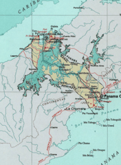
Map of the Panama Canal Zone. from the National Atlas archive copy at the Wayback Machine via American Memory.
This map was obtained from an edition of the National Atlas of the United States. Like almost all works of the U.S. federal government, works from the National Atlas are in the public domain in the United States.
Online access: NationalAtlas.gov | 1970 print edition: Library of Congress, Perry-Castañeda Library
|
Ursprunglig uppladdningslogg
| Datum/Tid | Dimensioner | Användare | Kommentar |
|---|---|---|---|
| 29 april 2005, 04:29:04 | 520 × 708 (314279 bytes) | Hoshie (diskussion · bidrag) | Map of the Panama Canal Zone. from the [http://www.nationalatlas.gov/ National Atlas] via [http://memory.loc.gov/ammem/gmdhtml/census3.html American Memory]. {{PD-USGov-Atlas}} |
Filhistorik
Klicka på ett datum/klockslag för att se filen som den såg ut då.
| Datum/Tid | Miniatyrbild | Dimensioner | Användare | Kommentar | |
|---|---|---|---|---|---|
| nuvarande | 1 oktober 2014 kl. 11.24 | | 520 × 708 (265 kbyte) | RokerHRO | optipng -o7 → 23.74% decrease |
| 29 augusti 2014 kl. 12.52 |  | 520 × 708 (348 kbyte) | GifTagger | Bot: Converting file to superior PNG file. (Source: CanalZone.gif). This GIF was problematic due to non-greyscale color table. |
Filanvändning
Följande 3 sidor använder den här filen:
Global filanvändning
Följande andra wikier använder denna fil:
- Användande på ang.wikipedia.org
- Användande på ar.wikipedia.org
- Användande på be.wikipedia.org
- Användande på bg.wikipedia.org
- Användande på bn.wikipedia.org
- Användande på ca.wikipedia.org
- Användande på cs.wikipedia.org
- Användande på da.wikipedia.org
- Användande på de.wikipedia.org
- Användande på en.wikipedia.org
- Användande på eo.wikipedia.org
- Användande på es.wikipedia.org
- Användande på fa.wikipedia.org
- Användande på fr.wikipedia.org
- Användande på he.wikipedia.org
- Användande på hu.wikipedia.org
- Användande på id.wikipedia.org
- Användande på it.wikipedia.org
- Användande på ja.wikipedia.org
- Användande på ka.wikipedia.org
- Användande på ko.wikipedia.org
Visa mer globalt användande av denna fil.