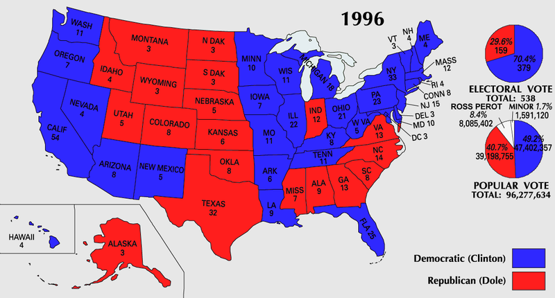
Fil:ElectoralCollege1996-Large.png
Sidans innehåll stöds inte på andra språk.
Från Wikipedia

Originalfil(1 182 × 635 pixlar, filstorlek: 171 kbyte, MIME-typ: image/png)

U.S. presidential election maps
from the National Atlas of the United States
See also: SVG maps
1789 · 1792 · 1796 · 1800 · 1804 · 1808 · 1812 · 1816 · 1820 · 1824 · 1828 · 1832 · 1836 · 1840 · 1844 · 1848 · 1852 · 1856 · 1860 · 1864 · 1868 · 1872 · 1876 · 1880 · 1884 · 1888 · 1892 · 1896 · 1900 · 1904 · 1908 · 1912 · 1916 · 1920 · 1924 · 1928 · 1932 · 1936 · 1940 · 1944 · 1948 · 1952 · 1956 · 1960 · 1964 · 1968 · 1972 · 1976 · 1980 · 1984 · 1988 · 1992 · 1996 · 2000 · 2004

(this template: · view · discuss)


Sammanfattning

Beskrivning
English: 1996 Electoral College Map
Källa https://nationalmap.gov/small_scale/printable/elections.html
Skapare United States Geological Survey
Andra versioner
En vektorversion av denna bild (SVG) finns tillgänglig.
Den skall användas istället för denna rasterbild, när det är fördelaktigt.

File:ElectoralCollege1996-Large.png → File:ElectoralCollege1996WithPieCharts.svg

För mer information om vektorgrafik, se artikeln Commons transition to SVG (engelska).
Det finns också information om MediaWikis stöd för SVG-bilder (engelska).

På andra språk
Alemannisch  Bahasa Indonesia  Bahasa Melayu  British English  català  čeština  dansk  Deutsch  eesti  English  español  Esperanto  euskara  français  Frysk  galego  hrvatski  Ido  italiano  lietuvių  magyar  Nederlands  norsk bokmål  norsk nynorsk  occitan  Plattdüütsch  polski  português  português do Brasil  română  Scots  sicilianu  slovenčina  slovenščina  suomi  svenska  Tiếng Việt  Türkçe  vèneto  Ελληνικά  беларуская (тарашкевіца)  български  македонски  нохчийн  русский  српски / srpski  татарча/tatarça  українська  ქართული  հայերեն  বাংলা  தமிழ்  മലയാളം  ไทย  한국어  日本語  简体中文  繁體中文  עברית  العربية  فارسی  +/−
Ny SVG-bild

Licensiering

Public domain
This map was obtained from an edition of the National Atlas of the United States. Like almost all works of the U.S. federal government, works from the National Atlas are in the public domain in the United States.
Online access: NationalAtlas.gov | 1970 print edition: Library of Congress, Perry-Castañeda Library

čeština | Deutsch | English | français | Bahasa Indonesia | italiano | македонски | മലയാളം | sicilianu | 中文 | 中文(简体)‎ | 中文(繁體)‎ | +/−

Filhistorik

Klicka på ett datum/klockslag för att se filen som den såg ut då.

Datum/TidMiniatyrbildDimensionerAnvändareKommentar
nuvarande25 juli 2007 kl. 12.21Miniatyrbild för versionen från den 25 juli 2007 kl. 12.211 182 × 635 (171 kbyte)Cardsplayer4life~commonswikiReverted to earlier revision
25 juli 2007 kl. 11.25Miniatyrbild för versionen från den 25 juli 2007 kl. 11.251 182 × 635 (110 kbyte)Joseph Solis in Australia~commonswiki{{PD-USGov-Atlas}} Category:1996 {{US presidential election maps}}
9 juli 2007 kl. 03.48Miniatyrbild för versionen från den 9 juli 2007 kl. 03.481 182 × 635 (171 kbyte)Cardsplayer4life~commonswiki{{PD-USGov-Atlas}} Category:1996 {{US presidential election maps}}
6 juli 2007 kl. 11.31Miniatyrbild för versionen från den 6 juli 2007 kl. 11.311 182 × 635 (110 kbyte)Joseph Solis in Australia~commonswiki{{PD-USGov-Atlas}} Category:1996 {{US presidential election maps}}
2 juli 2007 kl. 04.30Miniatyrbild för versionen från den 2 juli 2007 kl. 04.301 182 × 635 (171 kbyte)Cardsplayer4life~commonswiki{{PD-USGov-Atlas}} Category:1996 {{US presidential election maps}}
29 juni 2007 kl. 12.06Miniatyrbild för versionen från den 29 juni 2007 kl. 12.061 182 × 635 (110 kbyte)Joseph Solis in Australia~commonswiki{{PD-USGov-Atlas}} Category:1996 {{US presidential election maps}}
21 juni 2007 kl. 23.02Miniatyrbild för versionen från den 21 juni 2007 kl. 23.021 182 × 635 (171 kbyte)Cardsplayer4life~commonswiki{{PD-USGov-Atlas}} Category:1996 {{US presidential election maps}}
22 januari 2006 kl. 17.57Miniatyrbild för versionen från den 22 januari 2006 kl. 17.571 182 × 635 (110 kbyte)Red devil 666{{PD-USGov-Atlas}}

Följande sida använder den här filen:

Global filanvändning