
Fil:High Bridge Farmville Virginia.jpg

Storlek på förhandsvisningen: 776 × 599 pixlar. Andra upplösningar: 311 × 240 pixlar | 622 × 480 pixlar | 995 × 768 pixlar | 1 280 × 989 pixlar | 2 560 × 1 977 pixlar | 6 653 × 5 138 pixlar.
Originalfil (6 653 × 5 138 pixlar, filstorlek: 15,25 Mbyte, MIME-typ: image/jpeg)
| Denna fil tillhandahålls av Wikimedia Commons. Informationen nedan är kopierad från dess filbeskrivningssida. |
Sammanfattning
|
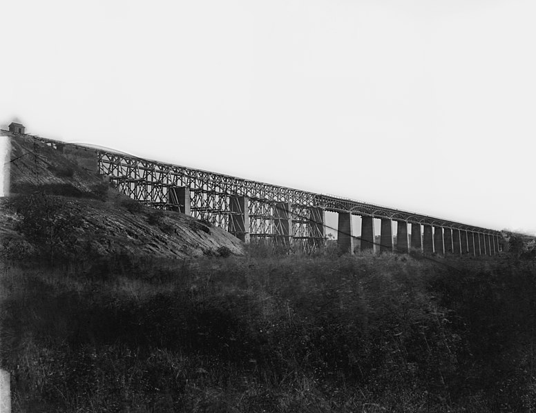
This is an image of a place or building that is listed on the National Register of Historic Places in the United States of America. Its reference number is 8000875. |
| Beskrivning |
English: Farmville, Virginia (vicinity). High bridge of the South Side Railroad across the Appomattox. NOTE: Title from Civil War caption books. Caption from negative sleeve: High Bridge across Appomattox River, south side railroad. Farmvill, Va., (vicinity) April 1865. Forms part of Civil War glass negative collection of the Library of Congress. No known restrictions on publication. |
||||||||||||||||||||||||||
| Datum | Bilden tagen under april 1865 | ||||||||||||||||||||||||||
| Källa |
https://www.loc.gov/pictures/resource/cwpb.03733/
|
||||||||||||||||||||||||||
| Skapare |
|
||||||||||||||||||||||||||
| Tillstånd (Återanvändning av denna fil) |
No known restrictions on publication. | ||||||||||||||||||||||||||


| Objektposition | | Se denna och andra närliggande bilder på: OpenStreetMap |
|---|
Transwiki information
Previously uploaded by Hlj to en.wikipedia on 2006-08-23. Överförd från en.wikipedia till Commons. Image cropped by Hal Jespersen. Transwiki approved by: w:en:User:Multichill
Image description page history
| link | date/time | username | edit summary |
|---|---|---|---|
| [1] | 11:06, 22 February 2008 | w:en:User:Multichill | |
| [2] | 12:16, 12 September 2007 | w:en:User:Parsecboy | |
| [3] | 17:14, 3 May 2007 | w:en:User:165.139.9.56 | |
| [4] | 23:21, 23 August 2006 | w:en:User:Hlj | (Image cropped by Hal Jespersen. TITLE: Farmville, Virginia (vicinity). High bridge of the South Side Railroad across the Appomattox CALL NUMBER: LC-B817- 7179[P&P] REPRODUCTION NUMBER: LC-DIG-cwpb-03733 (digital file from original neg.) No known res) |
![[1]](https://en.wikipedia.org/w/index.php?title=Image:High_Bridge_Farmville_Virginia.jpg&redirect=no&oldid=193248333)
![[2]](https://en.wikipedia.org/w/index.php?title=Image:High_Bridge_Farmville_Virginia.jpg&redirect=no&oldid=157362212)
![[3]](https://en.wikipedia.org/w/index.php?title=Image:High_Bridge_Farmville_Virginia.jpg&redirect=no&oldid=127997968)
![[4]](https://en.wikipedia.org/w/index.php?title=Image:High_Bridge_Farmville_Virginia.jpg&redirect=no&oldid=71483915)
Ursprunglig uppladdningslogg
| date/time | username | resolution | size | edit summary |
|---|---|---|---|---|
| 23:21, 23 August 2006 | w:en:User:Hlj | 904×629 | 115 KB | Image cropped by Hal Jespersen. TITLE: Farmville, Virginia (vicinity). High bridge of the South Side Railroad across the Appomattox CALL NUMBER: LC-B817- 7179[P&P] REPRODUCTION NUMBER: LC-DIG-cwpb-03733 (digital file from original neg.) No known res |
Licensiering
Detta verk är i public domain i Förenta staterna eftersom det publicerats före den 1 januari 1929.
Public domain works must be out of copyright in both the United States and in the source country of the work in order to be hosted on the Commons. If the work is not a U.S. work, the file must have an additional copyright tag indicating the copyright status in the source country.
|
Filhistorik
Klicka på ett datum/klockslag för att se filen som den såg ut då.
| Datum/Tid | Miniatyrbild | Dimensioner | Användare | Kommentar | |
|---|---|---|---|---|---|
| nuvarande | 4 maj 2020 kl. 01.54 | | 6 653 × 5 138 (15,25 Mbyte) | Taterian | higher resolution |
| 25 februari 2008 kl. 20.41 |  | 904 × 629 (115 kbyte) | BetacommandBot | Transwiki approved by: w:en:User:Multichill {{Information |Description={{en|Image cropped by Hal Jespersen. TITLE: Farmville, Virginia (vicinity). High bridge of the South Side Railroad across the Appomattox CALL NUMBER: LC-B817- 7179[P&P] REP |
Filanvändning
Följande sida använder den här filen:
Global filanvändning
Följande andra wikier använder denna fil:
- Användande på en.wikipedia.org
- Farmville, Virginia
- Appomattox campaign
- Battle of High Bridge
- High Bridge (Appomattox River)
- High Bridge Trail State Park
- List of bridges on the National Register of Historic Places in Virginia
- National Register of Historic Places listings in Cumberland County, Virginia
- National Register of Historic Places listings in Prince Edward County, Virginia
- Användande på en.wikivoyage.org
- Användande på es.wikipedia.org
- Användande på ja.wikipedia.org
- Användande på nl.wikipedia.org
- Användande på ru.wikipedia.org
- Användande på www.wikidata.org