
Fil:Lizars Mexico & Guatimala 1831 UTA.jpg
Storlek på förhandsvisningen: 708 × 600 pixlar. Andra upplösningar: 283 × 240 pixlar | 567 × 480 pixlar | 907 × 768 pixlar | 1 209 × 1 024 pixlar | 2 418 × 2 048 pixlar | 6 185 × 5 238 pixlar.
Originalfil (6 185 × 5 238 pixlar, filstorlek: 11,59 Mbyte, MIME-typ: image/jpeg)
| Denna fil tillhandahålls av Wikimedia Commons. Informationen nedan är kopierad från dess filbeskrivningssida. |
Sammanfattning
| Titel |
English: Mexico & Guatimala [sic] |
||||||||||||||||||||||||||
| Beskrivning |
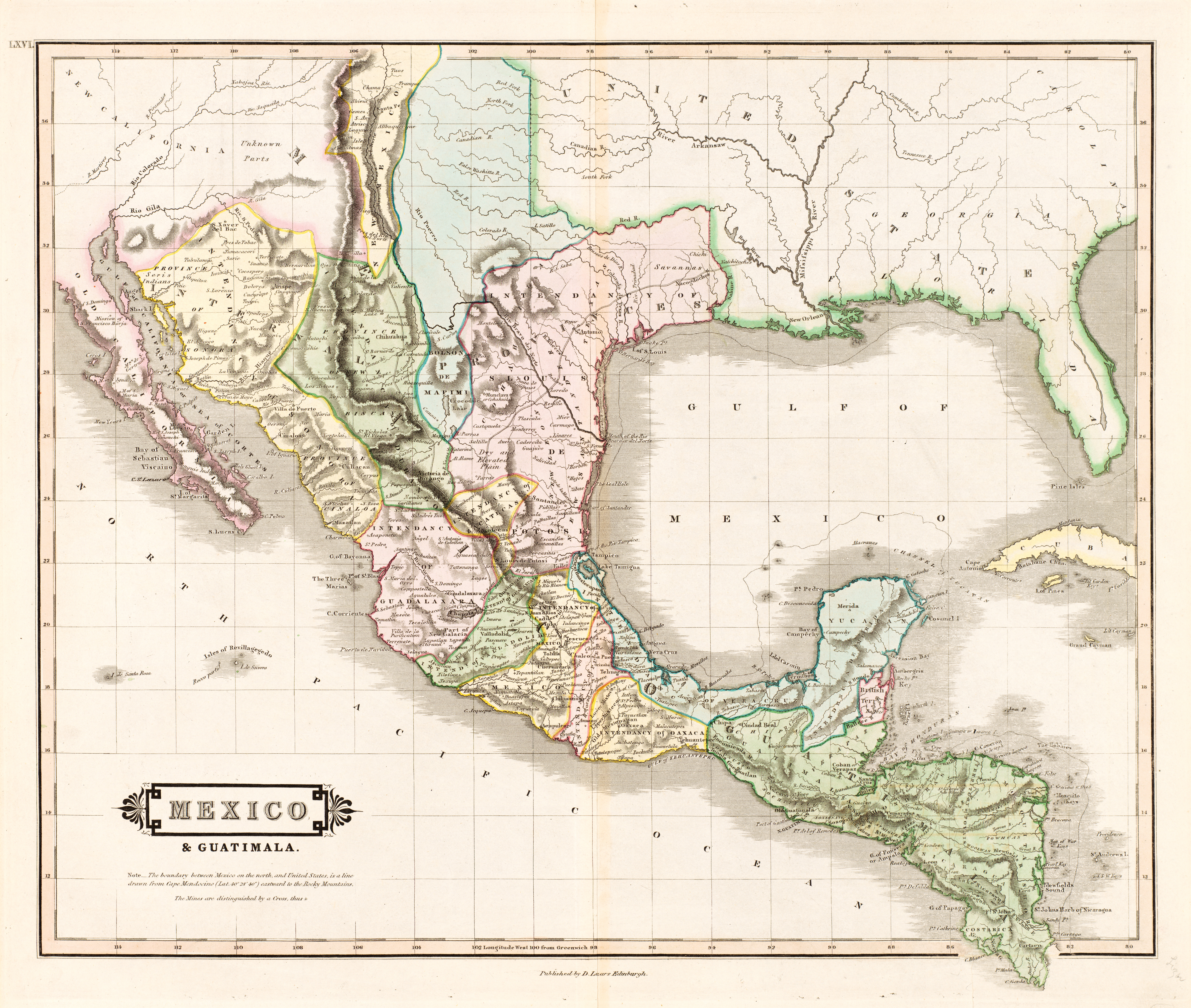
English: The creator of this map was probably Daniel Lizars II (1793-1875), the son of Edinburgh map engraver and publisher Daniel Lizars I (1754-1812) and younger brother of William Home Lizars (1788-1859). Shortly after producing the map, Daniel II went bankrupt in 1832 and emigrated to Canada in 1833. Lizars' map shows Mexico's administrative districts as Intendencies (Intendencias) and Internal Provinces (Provincias Internas) dating from the Spanish era. His depiction of the area that became Texas is notably jarring to modern viewers because his map further exaggerated some of the cartographic errors of his predecessors and contemporaries: particularly, a southerly "dip" of the middle Red River and the southerly courses of the Trinity, Brazos, and Colorado Rivers (which actually flow southeasterly). Settlements shown include Nacogdoches, "St." Antonio, and "Loredo". Interestingly, Lizars included the "British Territory" that became British Honduras or Belize. British logging settlements existed in the territory by the late eighteenth century and, although the British government had been hesitant to create a colony for fear of provoking the Spanish, settlers there were largely self-governing. |
||||||||||||||||||||||||||
| Datum | c:a 1831 | ||||||||||||||||||||||||||
| Källa | UTA Libraries Cartographic Connections: karta / text | ||||||||||||||||||||||||||
| Skapare |
|
||||||||||||||||||||||||||
| Förvärvsinformation |
English: The University of Texas at Arlington Libraries Special Collections, Gift of Virginia Garrett |
||||||||||||||||||||||||||
| Geotemporär data | |||||||||||||||||||||||||||
| Kartposition |
Mexiko Guatemala Texas |
||||||||||||||||||||||||||
| Georeferering | Om opassande sätt warp_status = skip för att dölja. | ||||||||||||||||||||||||||
| Bibliografisk data | |||||||||||||||||||||||||||
| Publikation |
The Edinburgh Geographical and Historical Atlas |
||||||||||||||||||||||||||
| Skapare |
John Hamilton |
||||||||||||||||||||||||||
| Utgivningsort |
Edinburgh London Dublin |
||||||||||||||||||||||||||
| Utgivare |
John Hamilton Whittaker, Treacher & Co. W. Curry, Jun. & Co. |
||||||||||||||||||||||||||
| Arkivarisk data | |||||||||||||||||||||||||||
| Samling |
|
||||||||||||||||||||||||||
| Mått | höjd: 42 cm; bredd: 51,5 cm | ||||||||||||||||||||||||||
| Teknik/material | färgad gravyr på papper | ||||||||||||||||||||||||||
| artwork-references |
Worms, Laurence; Ashley Baynton-Williams (2011) British Map Engravers, London: Rare Book Society, pp. 406–409 |
||||||||||||||||||||||||||
| Andra versioner | |||||||||||||||||||||||||||
.jpg)
Licensiering

|
This file was provided to Wikimedia Commons by the University of Texas at Arlington Libraries as part of a cooperation project. The University of Texas at Arlington Libraries is part of the University of Texas at Arlington, a public research university located in Arlington, Texas.
|
|
Upphovsmannen dog 1875, så detta verk är också upphovsrättsfritt i länder och områden där upphovsrätten förfaller 100 år eller färre efter upphovsmannens död. Detta verk är public domain i Förenta staterna eftersom det publicerades före den 1 januari 1929. | |
| Denna fil har identifierats som fri från kända begränsningar enligt upphovsrätten, inklusive alla relaterade och närliggande rättigheter. | |
Filhistorik
Klicka på ett datum/klockslag för att se filen som den såg ut då.
| Datum/Tid | Miniatyrbild | Dimensioner | Användare | Kommentar | |
|---|---|---|---|---|---|
| nuvarande | 13 juli 2019 kl. 15.26 | | 6 185 × 5 238 (11,59 Mbyte) | Michael Barera | == {{int:filedesc}} == {{Map |title = ''Mexico & Guatimala'' [sic] |description = {{en|The creator of this map was probably Daniel Lizars II (1793-1875), the son of Edinburgh map engraver and publisher Daniel Lizars I (1754-1812) and younger brother of William Home Lizars (1788-1859). Shortly after producing the map, Daniel II went bankrupt in 1832 and emigrated to Canada in 1833. Lizars' map shows Mexico's administrative districts as Intendencies (''Intendencias'') and In... |
Filanvändning
Inga sidor använder den här filen.
Global filanvändning
Följande andra wikier använder denna fil:
- Användande på en.wikipedia.org
- Användande på es.wikipedia.org
- Användande på hr.wikipedia.org
- Användande på sh.wikipedia.org