
Fil:Magnetic meridians lat 30 long 0 1000x1000.png
Originalfil (1 000 × 1 000 pixlar, filstorlek: 641 kbyte, MIME-typ: image/png)
| Denna fil tillhandahålls av Wikimedia Commons. Informationen nedan är kopierad från dess filbeskrivningssida. |
Sammanfattning
| Beskrivning |
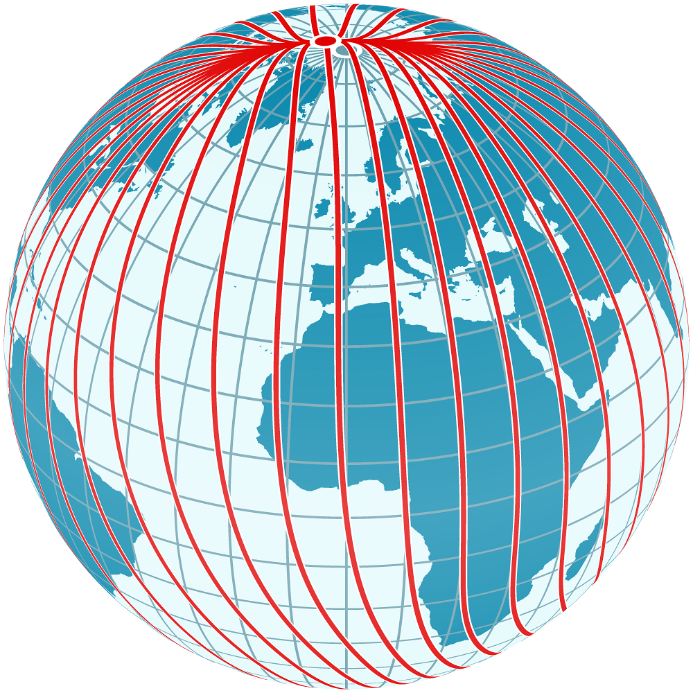
English: The diagram shows the magnetic meridians of the Earth's magnetic field. It is centered on the point at latitude 30° and longitude 0°.
The magnetic meridians (not to be confused with magnetic field lines) follow the directions shown by a magnetic compass, that is, they follow the direction of the horizontal component of the field lines in the vicinity of the Earth's surface and thus show the shape of the field. The angle between the magnetic meridians (red) and the geographic meridians (blue, running precisely north-south) is the magnetic declination. The diagram demonstrates the irregularities of the Earth's magnetic field and the fact that in general compasses point neither towards the geographic north pole nor towards the magnetic north pole. The magnetic field was computed using the coefficients of the International Geomagnetic Reference Field for the epoch 2010. |
| Datum | |
| Källa | Computed and drawn by myself, using File:Mercator_Projection.svg and File:Mercator-proj.png for the globe texture |
| Skapare | User:Sch |
Licensiering

|
Tillstånd ges att kopiera, distribuera och/eller modifiera detta dokument under villkoren i GNU Free Documentation License, Version 1.2 eller senare version publicerad av Free Software Foundation, utan oföränderliga avsnitt, framsidestexter eller baksidestexter. En kopia av licensen ingår i avsnittet GNU Free Documentation License. |
- Du är fri:
- att dela – att kopiera, distribuera och sända verket
- att remixa – att skapa bearbetningar
- På följande villkor:
- erkännande – Du måste ge lämpligt erkännande, ange en länk till licensen och indikera om ändringar har gjorts. Du får göra det på ett lämpligt sätt, men inte på ett sätt som antyder att licensgivaren stödjer dig eller din användning.
- dela lika – Om du remixar, transformerar eller bygger vidare på materialet måste du distribuera dina bidrag under samma eller en kompatibel licens som originalet.
Filhistorik
Klicka på ett datum/klockslag för att se filen som den såg ut då.
| Datum/Tid | Miniatyrbild | Dimensioner | Användare | Kommentar | |
|---|---|---|---|---|---|
| nuvarande | 9 april 2014 kl. 01.16 | | 1 000 × 1 000 (641 kbyte) | Sch | {{Information |Description ={{en|1=The diagram shows the magnetic meridians of the Earth's magnetic field. It is centered on the point at latitude 30° and longitude 0°. The magnetic meridians (not to be confused with magnetic field lines) follow... |
Filanvändning
Följande sida använder den här filen:
Global filanvändning
Följande andra wikier använder denna fil:
- Användande på de.wikipedia.org