
Fil:Map of The Hotakids.png
Det finns ingen version med högre upplösning.
Map_of_The_Hotakids.png (620 × 429 pixlar, filstorlek: 27 kbyte, MIME-typ: image/png)
| Denna fil tillhandahålls av Wikimedia Commons. Informationen nedan är kopierad från dess filbeskrivningssida. |
Sammanfattning
| Beskrivning |
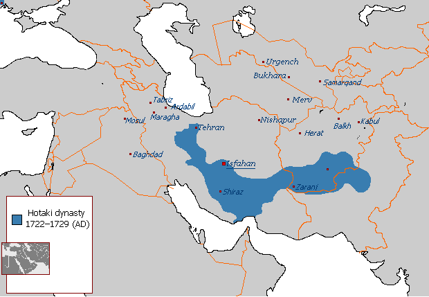
English: Map of The Hotakids from 1722 to 1729 |
| Datum | 29 augusti 2007 (ursprungligt uppladdningsdatum) |
| Källa |
Eget arbete, Sources consulted in the making of this map include: The Fall of the Safavi Dynasty and the Afghan Occupation of Persia by Laurence Lockhart The Afghan Occupation of Safavid Persia 1721-1729 by Willem Floor Articles from Encyclopedia Iranica History of the Wars 1721-1738 by Abraham of Erevan and translated by George A. Bournoutian The Chronicles of a Traveller: Or, A History of the Afghan Wars with Persia by Tadeusz Judas Krusiński |
| Skapare | Arab Hafez på engelska Wikipedia |
Licensiering
| Detta verk har gjorts tillgänglig som public domain av dess skapare, Arab Hafez på engelska Wikipedia. Detta gäller globalt. I vissa länder kan detta inte vara juridiskt möjligt; i så fall: Arab Hafez ger envar rätten att använda detta verk för alla ändamål, utan några villkor, förutom villkor som lagen ställer. |
Ursprunglig uppladdningslogg
Överförd från en.wikipedia till Commons.
Den ursprungliga beskrivningssidan fanns här. Alla följande användarnamn finns på en.wikipedia.
- 2007-08-29 21:49 Arab Hafez 620×429× (24487 bytes)
Filhistorik
Klicka på ett datum/klockslag för att se filen som den såg ut då.
| Datum/Tid | Miniatyrbild | Dimensioner | Användare | Kommentar | |
|---|---|---|---|---|---|
| nuvarande | 17 augusti 2021 kl. 15.42 | | 620 × 429 (27 kbyte) | Kailanmapper | Reverted to version as of 16:37, 31 July 2021 (UTC) if you would read the sources you would know its accurate |
| 15 augusti 2021 kl. 23.20 |  | 620 × 429 (18 kbyte) | Casperti | Reverted to version as of 12:38, 31 July 2021 (UTC) Do not engage in a conflict on Wiki commons open a discussion where you get consensus for it | |
| 31 juli 2021 kl. 18.37 |  | 620 × 429 (27 kbyte) | Noorullah21 | Reverted to version as of 12:51, 28 July 2021 (UTC) Final edit before this traerses to an edit war, first of all, the ottoman hotak war ended 1-2 years prior to this map, this map is a 1728-1729 hotak map. 2. The old map is incredibly inaccurate, and exaggerated claims throughout, it is unsourced and a wrong map. Hence why it is being replaced with the one Kalilan made, a much more accurate map. | |
| 31 juli 2021 kl. 14.38 |  | 620 × 429 (18 kbyte) | Casperti | Reverted to version as of 10:58, 28 July 2021 (UTC) Against all reliable sources and consensus. Besides the Ottoman-Hotak war Is here ignored | |
| 28 juli 2021 kl. 14.51 |  | 620 × 429 (27 kbyte) | Kailanmapper | Reverted to version as of 03:16, 28 July 2021 (UTC) the ip addresses involved haven't even tried to address my claims after several days. Plus Wikipedia literally says that unsourced information should be challenged and removed. I initially uploaded my own work separately but it got removed countless times from those very ip adresses who are refusing to say anything | |
| 28 juli 2021 kl. 12.58 |  | 620 × 429 (18 kbyte) | Xerxes1985 | Reverted to version as of 02:20, 28 July 2021 (UTC)inaccurate or accurate doesn’t matter, Again, where’s your consensus for this version? Upload your own work separately if you want to | |
| 28 juli 2021 kl. 05.16 |  | 620 × 429 (27 kbyte) | Kailanmapper | Reverted to version as of 20:53, 27 July 2021 (UTC) again, that is inaccurate and unsourced | |
| 28 juli 2021 kl. 04.20 |  | 620 × 429 (18 kbyte) | Xerxes1985 | Reverted to version as of 11:10, 27 July 2021 (UTC) No consensus for this map | |
| 27 juli 2021 kl. 22.53 |  | 620 × 429 (27 kbyte) | Noorullah21 | The old map is inaccurate, read the talk page please. | |
| 27 juli 2021 kl. 13.10 |  | 620 × 429 (18 kbyte) | Mukhis125 | Reverted to version as of 08:28, 19 August 2011 (UTC) |
Filanvändning
Följande sida använder den här filen:
Global filanvändning
Följande andra wikier använder denna fil:
- Användande på ar.wikipedia.org
- Användande på ast.wikipedia.org
- Användande på bn.wikipedia.org
- Användande på en.wikipedia.org
- Användande på eo.wikipedia.org
- Användande på et.wikipedia.org
- Användande på fa.wikipedia.org
- Användande på fi.wikipedia.org
- Användande på he.wikipedia.org
- Användande på hr.wikipedia.org
- Användande på id.wikipedia.org
- Användande på it.wikipedia.org
- Användande på nl.wikipedia.org
- Användande på no.wikipedia.org
- Användande på pnb.wikipedia.org
- Användande på ps.wikipedia.org
- Användande på pt.wikipedia.org
- Användande på ru.wikipedia.org
- Användande på sh.wikipedia.org
- Användande på tg.wikipedia.org
- Användande på tr.wikipedia.org
- Användande på uk.wikipedia.org
- Användande på www.wikidata.org
- Användande på zh.wikipedia.org