
Fil:Map of Tierra del Fuego showing Ona, Yahgan, Haush.jpg

Originalfil (2 823 × 2 179 pixlar, filstorlek: 1,76 Mbyte, MIME-typ: image/jpeg)
| Denna fil tillhandahålls av Wikimedia Commons. Informationen nedan är kopierad från dess filbeskrivningssida. |
Sammanfattning
| Beskrivning |
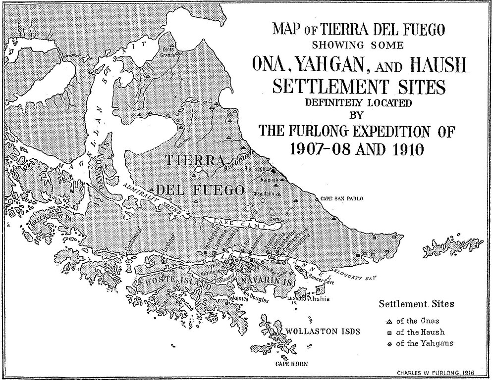
English: Fig. 4— Map of Tierra del Fuego showing some Ona, Yahgan, and Haush settlement sites. Scale,
1 :4,800,000. Note: The site at Cape San Pablo is an Ona site and should be represented by a triangle. Names have been given to these sites whenever possible. All are aboriginal names except the follow- ing: Gente Grande, Rio Fuego, Haberton, Cambesceres, Banner Cove, Rio Douglas, Mussels Bay, Button Island. The exact location of Lushoof is doubtful. Cuchawulaf is the name applied to the island and probably to its principal camp site. There are many other settlement sites not shown here. Some of those shown have been abandoned. With one or two exceptions these are or have been important settlements, supporting a fluctuating population, varying from a few families to perhaps over three hundred in case of the Yahgans, to perhaps one hundred in case of the Onas, but usually only small groups in the case of the Haush. Note the center of Yahgan population in Yahga and vicinity. |
| Datum | |
| Källa | Furlong, Charles Wellington. “Tribal Distribution and Settlements of the Fuegians, Comprising Nomenclature, Etymology, Philology, and Populations.” Geographical Review 3, no. 3 (1917): 169–87. https://doi.org/10.2307/207659; https://ia801605.us.archive.org/BookReader/BookReaderImages.php?zip=/12/items/jstor-207659/207659_jp2.zip&file=207659_jp2/207659_0009.jp2&scale=2.6745607333842627&rotate=0 |
| Skapare | Furlong, Charles Wellington |
Licensiering
Denna mediafil är allmän egendom i Förenta staterna. Detta gäller amerikanska verk där upphovsrätten har gått ut, ofta p.g.a. att den första publiceringen skedde före den 1 januari 1929. Se denna sida för mer information.
|
 | |
 |
Denna bild kanske inte är allmän egendom utanför Förenta staterna. Detta gäller speciellt de länder och områden där regeln om kortare sikt inte gäller för amerikanska verk; som Kanada, Fastlandskina (inte Hong Kong eller Macao), Tyskland, Mexiko och Schweiz. Skaparen och publiceringsåret är viktig information och måste anges. Se Wikipedia:Public domain och Wikipedia:Copyrights för mer information.
|
Filhistorik
Klicka på ett datum/klockslag för att se filen som den såg ut då.
| Datum/Tid | Miniatyrbild | Dimensioner | Användare | Kommentar | |
|---|---|---|---|---|---|
| nuvarande | 13 juli 2016 kl. 20.44 | | 2 823 × 2 179 (1,76 Mbyte) | Rec79 | {{Information |Description ={{en|1=Fig. 4— Map of Tierra del Fuego showing some Ona, Yahgan, and Haush settlement sites. Scale, 1 :4,800,000. Note: The site at Cape San Pablo is an Ona site and should be represented by a triangle. Names have be... |
Filanvändning
Följande sida använder den här filen:
Global filanvändning
Följande andra wikier använder denna fil: