
Fil:Michigan Basin 2.jpg
Michigan_Basin_2.jpg (357 × 360 pixlar, filstorlek: 47 kbyte, MIME-typ: image/jpeg)
| Denna fil tillhandahålls av Wikimedia Commons. Informationen nedan är kopierad från dess filbeskrivningssida. |
Sammanfattning
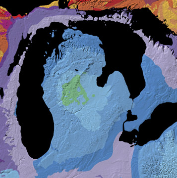
A geological map of the Michigan Basin.
Source: Michigan Basin archive copy at the Wayback Machine, The North American Tapestry of Time and Terrain, United States Department of the Interior. Text from this web page follows below.
A giant incomplete bull's-eye is centered on the state of Michigan. Radiating outward to Ohio, Indiana, Illinois, Wisconsin, and Ontario, this annular pattern outlines the Michigan Basin. The Basin is a bowl-shaped structure of uncertain origin that contains over 2.5 miles (4 km) of inward-dipping Paleozoic strata and a veneer of Jurassic sedimentary rocks. This curious basin is located in the less tectonically-active interior of the continent, bordered by the Appalachian and Rocky Mountains. It subsided rapidly from Cambrian to Silurian time and filled with shallow-water marine sediments, some of which contain deposits of petroleum, coal, and salt.
Licensiering
Detta verk är under public domain (allmän egendom) i USA då verket gjordes av en tjänsteman eller anställd i USA: s regering som en del av den personens officiella arbete i enlighet med villkoren i Title 17, Kapitel 1, Sektion 105 av US Code (Amerikas förenta staters kodifierade lagsamling). Läs gärna Copyright (på engelska).
Observera: Detta gäller endast originalverk av den federala regeringen och inte till arbetet i någon enskild amerikansk delstat, amerikansk territorium, samhälle, län, kommun, eller någon annan delsektion. Den här mallen gäller även inte för frimärksmotiv som gjots och eller producerats av United States Postal Service efter 1978. (Se 206.02(b) of Compendium II: Copyright Office Practices). Det gäller inte heller för vissa amerikanska mynt; se The US Mint Terms of Use.
|
 | |
| Denna fil har identifierats som fri från kända begränsningar enligt upphovsrätten, inklusive alla relaterade och närliggande rättigheter. | ||
Filhistorik
Klicka på ett datum/klockslag för att se filen som den såg ut då.
| Datum/Tid | Miniatyrbild | Dimensioner | Användare | Kommentar | |
|---|---|---|---|---|---|
| nuvarande | 15 juni 2007 kl. 13.29 | | 357 × 360 (47 kbyte) | Avenue | A geological map of the Michigan Basin. Source: [http://nationalatlas.gov/articles/geology/features/michiganbasin.html Michigan Basin], The North American Tapestry of Time and Terrain, United States Department of the Interior. Text from this web page fo |
Filanvändning
Följande 2 sidor använder den här filen:
Global filanvändning
Följande andra wikier använder denna fil:
- Användande på ar.wikipedia.org
- Användande på en.wikipedia.org
- Användande på en.wikibooks.org
- Användande på it.wikipedia.org
- Användande på ru.wikipedia.org
- Användande på sh.wikipedia.org
- Användande på sr.wikipedia.org
- Användande på www.wikidata.org